Warren County, Missouri
 | |
| Math | sir |
|---|---|
| Enwyd ar ôl | Joseph Warren |
| Prifddinas | Warrenton |
| Poblogaeth | 35,532 |
| Sefydlwyd | |
| Daearyddiaeth | |
| Gwlad | |
| Arwynebedd | 438 mi² |
| Talaith | Missouri |
| Yn ffinio gyda | Gasconade County, Montgomery County, Lincoln County, St. Charles County, Franklin County |
| Cyfesurynnau | 38.77°N 91.16°W |
 | |
Sir yn nhalaith Missouri, Unol Daleithiau America yw Warren County. Cafodd ei henwi ar ôl Joseph Warren. Sefydlwyd Warren County, Missouri ym 1833 a sedd weinyddol y sir (a elwir weithiau'n 'dref sirol' neu'n 'brifddinas y sir') yw Warrenton.
Mae ganddi arwynebedd o 438. Allan o'r arwynebedd hwn, y canran o ffurfiau dyfrol, megis llynnoedd ac afonydd, yw 2.1% . Yn ôl cyfrifiad y wlad, poblogaeth y sir yw: 35,532 (1 Ebrill 2020)[1]. Mewn cymhariaeth, yn 2016 roedd poblogaeth Caerdydd yn 361,462 a Rhyl tua 26,000.[2]
Mae'n ffinio gyda Gasconade County, Montgomery County, Lincoln County, St. Charles County, Franklin County. Cedwir rhestr swyddogol o henebion ac adeiladau cofrestredig y sir yn: National Register of Historic Places listings in Warren County, Missouri.
 |
|
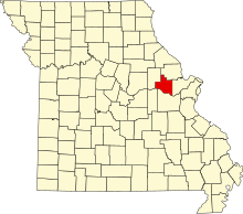
| Map o leoliad y sir o fewn Missouri |
Lleoliad Missouri o fewn UDA |
Ceir sawl sir o’r un enw gan gynnwys:
- Warren County, Efrog Newydd
- Warren County, Georgia
- Warren County, Gogledd Carolina
- Warren County, Illinois
- Warren County, Indiana
- Warren County, Iowa
- Warren County, Kentucky
- Warren County, Mississippi
- Warren County, Missouri
- Warren County, New Jersey
- Warren County, Ohio
- Warren County, Pennsylvania
- Warren County, Tennessee
- Warren County, Virginia
Trefi mwyaf
[golygu | golygu cod]Mae gan y sir yma boblogaeth o tua 35,532 (1 Ebrill 2020)[1]. Dyma rai o'r dinasoedd, trefi neu gymunedau mwyaf poblog y sir:
Rhestr Wicidata:
| Tref neu gymuned | Poblogaeth | Arwynebedd |
|---|---|---|
| Hickory Grove Township | 11596[3] | |
| Warrenton | 8429[3] | 22.311339[4] 21.919021[5] |
| North Elkhorn Township | 7817[3] | |
| South Elkhorn Township | 7440[3] | |
| Charrette Township | 5800[3] | |
| Wright City | 4881[3] | 15.771015[4] 15.695942[5] |
| Pinckney Township | 1267[3] | |
| Marthasville | 1245[3] | 2.223129[4] 2.223126[5] |
| Camp Branch Township | 975[3] | |
| Truesdale | 853[3] | 3.355299[4] 3.335602[5] |
| Bridgeport Township | 637[3] | |
| Innsbrook | 596[3] | 28.676967[4] 28.611334[5] |
| Pendleton | 34[3] | 0.09 |
| Three Creeks | 8[3] | 4.89 |
| |||||
Cyfeiriadau
[golygu | golygu cod]- ↑ 1.0 1.1 https://data.census.gov/cedsci/table?t=Populations%20and%20People&g=0100000US,%241600000&y=2020. Cyfrifiad yr Unol Daleithiau 2020. golygydd: Biwro Cyfrifiad yr Unol Daleithiau. dyddiad cyrchiad: 1 Ionawr 2022.
- ↑ statswales.gov.wales; adalwyd 25 Mawrth 2020.
- ↑ 3.00 3.01 3.02 3.03 3.04 3.05 3.06 3.07 3.08 3.09 3.10 3.11 3.12 3.13 https://data.census.gov/cedsci/table?t=Populations%20and%20People&g=0100000US,%241600000&y=2020
- ↑ 4.0 4.1 4.2 4.3 4.4 2016 U.S. Gazetteer Files
- ↑ 5.0 5.1 5.2 5.3 5.4 2010 U.S. Gazetteer Files

