Somerset County, New Jersey
 | |
| Math | sir |
|---|---|
| Enwyd ar ôl | Gwlad yr Haf |
| Prifddinas | Somerville, New Jersey |
| Poblogaeth | 345,361 |
| Sefydlwyd | |
| Cylchfa amser | Cylchfa Amser y Dwyrain |
| Daearyddiaeth | |
| Gwlad | |
| Arwynebedd | 790 km² |
| Talaith | New Jersey |
| Yn ffinio gyda | Morris County, Union County, Middlesex County, Mercer County, Hunterdon County |
| Cyfesurynnau | 40.56°N 74.61°W |
 | |
Sir yn nhalaith New Jersey, Unol Daleithiau America, yw Somerset County. Cafodd ei henwi ar ôl Gwlad yr Haf. Sefydlwyd Somerset County, New Jersey, ym 1688 , a sedd weinyddol y sir (a elwir weithiau'n 'dref sirol' neu'n 'brifddinas y sir') yw Somerville, New Jersey.
Mae ganddi arwynebedd o 790 cilometr sgwâr. Allan o'r arwynebedd hwn, y canran o ffurfiau dyfrol, megis llynnoedd ac afonydd, yw 1% . Yn ôl cyfrifiad y wlad, poblogaeth y sir yw: 345,361 (1 Ebrill 2020)[1][2]. Mewn cymhariaeth, yn 2016 roedd poblogaeth Caerdydd yn 361,462 a Rhyl tua 26,000.[3]
Mae'n ffinio gyda Morris County, Union County, Middlesex County, Mercer County, Hunterdon County. Ceir 9 cylchfa amser yn UDA, ac mae'r sir hon yn perthyn i'r cylchfa amser a elwir yn Cylchfa Amser y Dwyrain.
 |
|
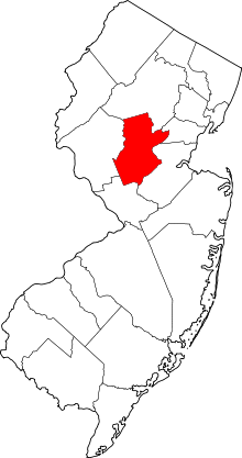
| Map o leoliad y sir o fewn New Jersey |
Lleoliad New Jersey o fewn UDA |
Ceir sawl sir o’r un enw gan gynnwys:
- Somerset County, Maine
- Somerset County, Maryland
- Somerset County, New Jersey
- Somerset County, Pennsylvania
Trefi mwyaf[golygu | golygu cod]
Mae gan y sir yma boblogaeth o tua 345,361 (1 Ebrill 2020)[1][2]. Dyma rai o'r dinasoedd, trefi neu gymunedau mwyaf poblog y sir:
Rhestr Wicidata:
| Tref neu gymuned | Poblogaeth | Arwynebedd |
|---|---|---|
| Franklin Township | 68364[4][5] | 46.846 |
| Bridgewater Township, New Jersey | 45977[4][5] | 32.51 |
| Hillsborough Township, New Jersey | 43276[4][5] | 55.001 |
| Bernards Township, New Jersey | 27830[4][5] | 24.061 |
| Montgomery, New Jersey | 23690[4][5] | 32.48 |
| North Plainfield, New Jersey | 22808[4][5] | 7.305403[6] 7.269951[7] |
| Warren Township, New Jersey | 15923[4][5] | 19.644 |
| Branchburg, New Jersey | 14940[4][5] | 20.279 |
| Somerville, New Jersey | 12346[4][5] | 6.132657[6] |
| Bound Brook, New Jersey | 11988[4][5] | 4.390026[6] 4.389028[7] |
| Manville, New Jersey | 10953[4][5] | 6.341977[6] 6.342175[7] |
| Bedminster, New Jersey | 8272[4][5] | 26.301 |
| Bernardsville, New Jersey | 7893[4][5] | 33.437141[6] 33.619176[7] |
| Raritan, New Jersey | 7835[4][5] | 5.267372[6] 5.275989[7] |
| Green Brook Township, New Jersey | 7281[4][5] | 4.481 |
| |||||
| |||||
Cyfeiriadau[golygu | golygu cod]
- ↑ 1.0 1.1 https://www.nj.gov/labor/lpa/census/2020/2020%20pl94%20Tables/2020_Mun/popARH%20MCD%20Cen20-Cen10.xlsx. dyddiad cyrchiad: 22 Ionawr 2022.
- ↑ 2.0 2.1 https://data.census.gov/cedsci/table?t=Populations%20and%20People&g=0100000US,%241600000&y=2020. Cyfrifiad yr Unol Daleithiau 2020. golygydd: Biwro Cyfrifiad yr Unol Daleithiau. dyddiad cyrchiad: 1 Ionawr 2022.
- ↑ statswales.gov.wales; adalwyd 25 Mawrth 2020.
- ↑ 4.00 4.01 4.02 4.03 4.04 4.05 4.06 4.07 4.08 4.09 4.10 4.11 4.12 4.13 4.14 https://www.nj.gov/labor/lpa/census/2020/2020%20pl94%20Tables/2020_Mun/popARH%20MCD%20Cen20-Cen10.xlsx
- ↑ 5.00 5.01 5.02 5.03 5.04 5.05 5.06 5.07 5.08 5.09 5.10 5.11 5.12 5.13 5.14 https://data.census.gov/cedsci/table?t=Populations%20and%20People&g=0100000US,%241600000&y=2020
- ↑ 6.0 6.1 6.2 6.3 6.4 6.5 2016 U.S. Gazetteer Files
- ↑ 7.0 7.1 7.2 7.3 7.4 2010 U.S. Gazetteer Files

