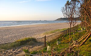
Byron Bay
Gwedd
town in New South Wales, Australia
enghraifft o'r canlynol
lleolir yn yr ardal weinyddol
lleolir yn y cylchfa amser
UTC+10:00
associated electoral district
Ballina
swyddogaeth y gwrthrych: electoral district of New South Wales
Richmond
swyddogaeth y gwrthrych: division of the Australian House of Representatives
cyfesurynnau'r lleoliad
poblogaeth
5,521[9]
dull penderfynu: Australian Census 2016
pwynt mewn amser: 9 Awst 2016
yn briodol i'r rhan: suburb and locality
6,330[11]
dull penderfynu: Australian Census 2021
pwynt mewn amser: 10 Awst 2021
yn briodol i'r rhan: suburb and locality
10,538[12]
dull penderfynu: Australian Census 2021
pwynt mewn amser: 10 Awst 2021
yn briodol i'r rhan: urban centre and locality
male population
2,683[9]
dull penderfynu: Australian Census 2016
pwynt mewn amser: 9 Awst 2016
yn briodol i'r rhan: suburb and locality
female population
2,841[9]
dull penderfynu: Australian Census 2016
pwynt mewn amser: 9 Awst 2016
yn briodol i'r rhan: suburb and locality
uchder uwch na lefel y môr
5 metr
yn rhannu ffin â
arwynebedd
12,406 cilometr sgwâr
cod post
2481
categori Comin
Byron Bay, New South Wales
prif gategori
Category:Byron Bay
categori ar gyfer pobl a fu farw yma
Q124433972
Cyfeiriadau
- ↑ Freebase Data Dumps, 28 Hydref 2013
- ↑ Ffeil Awdurdodi Rhyngwladol, 6 Mawrth 2019
- ↑ https://service.unece.org/trade/locode/au.htm
- ↑ n88238471, 16 Mawrth 2024, Library of Congress Authorities
- ↑ GeoNames
- ↑ MusicBrainz
- ↑ Flickr Shapefiles Public Dataset 2.0
- ↑ BBC Things
- ↑ 9.0 9.1 9.2 9.3 9.4 SSC10733
- ↑ 10.0 10.1 10.2 Geographical Names Register, KWjLjzUlMa
- ↑ https://www.abs.gov.au/census/find-census-data/quickstats/2021/SAL10731, QuickStats, 28 Mehefin 2022, Byron Bay, SAL10731
- ↑ https://www.abs.gov.au/census/find-census-data/quickstats/2021/UCL113004
- ↑ inferred from common points on the boundaries of two regions, https://linked.data.gov.au/dataset/asgsed3/SAL/10731, https://linked.data.gov.au/dataset/asgsed3/SAL/11886
- ↑ inferred from common points on the boundaries of two regions, https://linked.data.gov.au/dataset/asgsed3/SAL/10731, https://linked.data.gov.au/dataset/asgsed3/SAL/13571
- ↑ inferred from common points on the boundaries of two regions, https://linked.data.gov.au/dataset/asgsed3/SAL/10731, https://linked.data.gov.au/dataset/asgsed3/SAL/13699
- ↑ inferred from common points on the boundaries of two regions, https://linked.data.gov.au/dataset/asgsed3/SAL/10731, https://linked.data.gov.au/dataset/asgsed3/SAL/11477
- ↑ inferred from common points on the boundaries of two regions, https://linked.data.gov.au/dataset/asgsed3/SAL/10731, https://linked.data.gov.au/dataset/asgsed3/SAL/11049
- ↑ inferred from common points on the boundaries of two regions, https://linked.data.gov.au/dataset/asgsed3/SAL/10731, https://linked.data.gov.au/dataset/asgsed3/SAL/14011


