Nodyn:Infobox World Heritage Site
Syntax[golygu cod]
{{Infobox World Heritage Site
|Name        =
|Image       =  (optional)
|imagecaption=  (optional)
|Country     =  (optional)
|Type        =
|Criteria    =
|ID          =
|Link        =  (optional)
|Region      =
|Coordinates =  (optional; use {{coord}})
|Year        =
|Session     =  (optional)
|Extension   =  (optional)
|Danger      =  (optional)
|map         =  (optional)
|map_caption =  (optional)
|map_width   =  (optional)
|locmapin    =  (optional)
|relief      =  ("1" for relief map - if available)
|latitude    =  (optional)
|longitude   =  (optional)
}}
Notes[golygu cod]
| Africa | encompassing Sub-Saharan Africa |
| Arab States | Northern Africa and the Middle East |
| Asia-Pacific | Asia and Oceania |
| Europe and North America | Europe, Canada, USA |
| Latin America and the Caribbean | entire Western Hemisphere less Canada and USA |
Coordinates[golygu cod]
Microformat[golygu cod]
The HTML mark up produced by this template includes an hCard microformat, which makes the place-name and location parsable by computers, either acting automatically to catalogue article across Wikipedia, or via a browser tool operated by a person, to (for example) add the subject to an address book. Within the hCard is a Geo microformat, which additionally makes the coordinates (latitude & longitude) parsable, so that they can be, say, looked up on a map, or downloaded to a GPS unit. For more information about the use of microformats on Wikipedia, please see the microformat project.
Sub-templates[golygu cod]
If the place or venue has an "established", "founded", "opened" or similar date, use {{Start date}} (unless the date is before 1583 CE).
If it has a URL, use {{URL}}.
Please do not remove instances of these sub-templates.
Classes[golygu cod]
hCard uses HTML classes including:
- adr
- agent
- category
- county-name
- extended-address
- fn
- label
- locality
- nickname
- note
- org
- region
- street-address
- url
- vcard
Geo is produced by calling {{coord}}, and uses HTML classes:
- geo
- latitude
- longitude
Please do not rename or remove these classes; nor collapse nested elements which use them.
Precision[golygu cod]
When giving coordinates, please use an appropriate level of precision. Do not use {{Coord}}'s |name= parameter.
Example 1[golygu cod]
| Kathmandu Valley * | |
|---|---|
| Gwlad | Nepal |
| Math | Cultural |
| Meini prawf | iii, iv, vi |
| Cyfeiriad | 121 |
| Rhanbarth ** | Asia-Pacific |
| Hanes arysgrif | |
| Arysgrif | 1979 (3ydd Sesiwn) |
| Estyniadau | 2006 |
| Mewn perygl | since 2003 |
| * Enw fel y'i welir yn ôl Rhestr Treftadaeth y Byd ** Rhanbarth fel y'i dosbarthu'n ôl UNESCO | |
This example has no image:
{{Infobox World Heritage Site
|Name        = Kathmandu Valley
|Country     = [[Nepal]]
|Type        = Cultural
|Criteria    = iii, iv, vi
|ID          = 121
|Region      = Asia-Pacific
|Year        = 1979
|Danger      = since 2003
|Extension   = 2006
}}
Example 2[golygu cod]
| Kathmandu Valley * | |
|---|---|
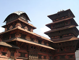
 The Kathmandu Darbar Square | |
| Gwlad | Nepal |
| Math | Cultural |
| Meini prawf | iii, iv, vi |
| Cyfeiriad | 121 |
| Rhanbarth ** | Asia-Pacific |
| Hanes arysgrif | |
| Arysgrif | 1979 (3ydd Sesiwn) |
| Estyniadau | 2006 |
| Mewn perygl | since 2003 |
| * Enw fel y'i welir yn ôl Rhestr Treftadaeth y Byd ** Rhanbarth fel y'i dosbarthu'n ôl UNESCO | |
This example uses an image of width 270px:
{{Infobox World Heritage Site
|Name        = Kathmandu Valley
|Image       = [[Image:basantapurpalace.JPG|270px|The Kathmandu Darbar Square]]
|Country     = [[Nepal]]
|Type        = Cultural
|Criteria    = iii, iv, vi
|ID          = 121
|Region      = Asia-Pacific
|Year        = 1979
|Danger      = since 2003
|Extension   = 2006
}}
Example 3[golygu cod]
| Kathmandu Valley * | |
|---|---|
 | |
| Gwlad | Nepal |
| Math | Cultural |
| Meini prawf | iii, iv, vi |
| Cyfeiriad | 121 |
| Rhanbarth ** | Asia-Pacific |
| Hanes arysgrif | |
| Arysgrif | 1979 (3ydd Sesiwn) |
| Estyniadau | 2006 |
| Mewn perygl | since 2003 |
|
[[File:Nodyn:Location map Nepal|220px|Infobox World Heritage Site is located in Nodyn:Location map Nepal]] <div style="font-size: 90%; line-height: 110%; position: relative; top: -1.5em; width: 6em; Gweithredydd < annisgwyl"><div style="position: absolute; z-index: 2; top: Gwall mynegiad: Heb adnabod y nod atalnodi "[".%; left: Gwall mynegiad: Heb adnabod y nod atalnodi "[".%; height: 0; width: 0; margin: 0; padding: 0;"><div style="position: relative; text-align: center; left: -Gwall mynegiad: Heb adnabod y nod atalnodi "[".px; top: -Gwall mynegiad: Heb adnabod y nod atalnodi "[".px; width: Nodyn:Location map Nepalpx; font-size: Nodyn:Location map Nepalpx;">  Location in Nepal | |
| * Enw fel y'i welir yn ôl Rhestr Treftadaeth y Byd ** Rhanbarth fel y'i dosbarthu'n ôl UNESCO | |
This example uses an infobox width of 20.8em with an image width of 230px:
{{Infobox World Heritage Site
|Name        = Kathmandu Valley
|infoboxwidth= 20.8em
|Image       = [[Image:basantapurpalace.JPG|230px|The Kathmandu Darbar Square]]
|Country     = [[Nepal]]
|Type        = Cultural
|Criteria    = iii, iv, vi
|ID          = 121
|Region      = Asia-Pacific
|Year        = 1979
|Danger      = since 2003
|Extension   = 2006
|locmapin    = Nepal
|relief      = 1
|latitude    = 27.704
|longitude   = 85.309
|map_caption = Location in Nepal
}}
| Mae'r ddogfennaeth uchod wedi ei thrawsgynnwys o Nodyn:Infobox World Heritage Site/doc. (golygu | hanes) Gall golygyddion arbrofi yn y tudalennau pwll tywod (creu | drych) a testcases (creu). Os gwelwch yn dda, ychwanegwch gategorïau a rhyngwicis at yr is-dudalen /doc. Is-dudalennau'r nodyn hwn. |
