
Delwedd:Tunisia Antica.jpg

Maint y rhagolwg: 399 × 600 picsel. Eglurdebau eraill: 159 × 240 picsel | 479 × 720 picsel.
Maint llawn ((479 × 720 picsel, maint y ffeil: 67 KB, ffurf MIME: image/jpeg))
| Disgrifiad |
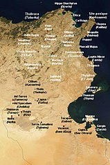
English: Satellite map of Tunisia, with ancient Punic and Roman archeological sites. White dot : important archeological sites. Red dot : other antic site. Personal work.
Français : Carte satellite de la Tunisie, avec d'anciens sites archéologiques puniques et romains. Point blanc: sites archéologiques importants. Point rouge: autre site antique. Travail personnel. |
| Dyddiad |
English: Satellite image from August 2001, derivative work from 15 September 2008 (original upload date) |
| Ffynhonnell | Image:Satellite image of Tunisia in August 2001.jpg [1] |
| Awdur | NASA's Visible Earth, derivative work by Ursus |
| Caniatâd (Ailddefnyddio'r ffeil hon) |
Sattelite image: PD-USGov-NASA, derivative work: PD-self |
| Diwygiadau eraill | Original, العربيَّة |
| Cafodd y gwaith hwn ei ryddhau i'r parth cyhoeddus gan ei awdur, Ursus. Mae hyn yn weithredol ledled y byd. Hwyrach nad yw hyn yn bosib yn ôl cyfraith rhai gwledydd; os felly: |
| This file is in the public domain in the United States because it was solely created by NASA. NASA copyright policy states that "NASA material is not protected by copyright unless noted". (See Template:PD-USGov, NASA copyright policy page or JPL Image Use Policy.) | ||
 |
Warnings:
|

|
This map image could be re-created using vector graphics as an SVG file. This has several advantages; see Commons:Media for cleanup for more information. If an SVG form of this image is available, please upload it and afterwards replace this template with
{{vector version available|new image name}}.
It is recommended to name the SVG file “Tunisia Antica.svg”—then the template Vector version available (or Vva) does not need the new image name parameter. |


Hanes y ffeil
Cliciwch ar ddyddiad / amser i weld y ffeil fel ag yr oedd bryd hynny.
| Dyddiad / Amser | Bawdlun | Hyd a lled | Defnyddiwr | Sylw | |
|---|---|---|---|---|---|
| cyfredol | 07:01, 26 Medi 2008 | | 479 × 720 (67 KB) | Ursus | {{Information |Description=reease with Beja/Vaga and Kebili |Source= |Date= |Author= |Permission= |other_versions= }} |
| 16:54, 22 Medi 2008 |  | 482 × 720 (67 KB) | Ursus | {{Information |Description=new release, more cities |Source= |Date= |Author= |Permission= |other_versions= }} | |
| 13:24, 16 Medi 2008 |  | 479 × 720 (49 KB) | Ursus | Reverted to version as of 08:48, 15 September 2008 | |
| 13:22, 16 Medi 2008 |  | 479 × 720 (50 KB) | Ursus | {{Information |Description= |Source= |Date= |Author= |Permission= |other_versions= }} | |
| 08:48, 15 Medi 2008 |  | 479 × 720 (49 KB) | Ursus | Satellite map of Tunisia, with antic punic and roman archeologic sites. Personnal work. |
Cysylltiadau'r ffeil
Mae'r 1 tudalennau a ddefnyddir isod yn cysylltu i'r ddelwedd hon:
Defnydd cydwici y ffeil
Mae'r wicis eraill hyn yn defnyddio'r ffeil hon:
- Y defnydd ar ar.wikipedia.org
- Y defnydd ar arz.wikipedia.org
- Y defnydd ar ca.wikipedia.org
- Y defnydd ar de.wikipedia.org
- Y defnydd ar eml.wikipedia.org
- Y defnydd ar en.wikipedia.org
- Y defnydd ar es.wikipedia.org
- Y defnydd ar fr.wikipedia.org
Gweld rhagor o'r defnydd cydwici o'r ffeil hon.