
Delwedd:Historic American Buildings Survey W. N. Manning, Photographer, May 14, 1935 FRONT AND SIDE VIEW N.E. - Tuckabatcha Masonic Lodge No. 863, U.S. Highway 80 and County Road 79, HABS ALA,57-CRAWF,1-1.tif

Maint rhagolwg JPG o ffeil TIF yw: 429 × 600 picsel. Eglurdebau eraill: 171 × 240 picsel | 343 × 480 picsel | 549 × 768 picsel | 732 × 1,024 picsel | 1,464 × 2,048 picsel | 3,575 × 5,000 picsel.
Maint llawn ((3,575 × 5,000 picsel, maint y ffeil: 17.05 MB, ffurf MIME: image/tiff))
Crynodeb
| Historic American Buildings Survey W. N. Manning, Photographer, May 14, 1935 FRONT AND SIDE VIEW N.E. - Tuckabatcha Masonic Lodge No. 863, U.S. Highway 80 and County Road 79, Crawford, Russell County, AL | ||||
|---|---|---|---|---|
| Teitl |
Historic American Buildings Survey W. N. Manning, Photographer, May 14, 1935 FRONT AND SIDE VIEW N.E. - Tuckabatcha Masonic Lodge No. 863, U.S. Highway 80 and County Road 79, Crawford, Russell County, AL |
|||
| Depicted place | Alabama; Russell County; Crawford | |||
| Hyd a lled | 5 x 7 in. | |||
| Y man y mae yn awr |
Library of Congress Prints and Photographs Division Washington, D.C. 20540 USA http://hdl.loc.gov/loc.pnp/pp.print |
|||
| Rhif catalogio |
HABS ALA,57-CRAWF,1-1 |
|||
| Cydnabyddiaeth |
|
|||
| Ffynhonnell | https://www.loc.gov/pictures/item/al0708.photos.006514p | |||
| Caniatâd (Ailddefnyddio'r ffeil hon) |
|
|||

| Camera location | | View this and other nearby images on: OpenStreetMap |
|---|
Hanes y ffeil
Cliciwch ar ddyddiad / amser i weld y ffeil fel ag yr oedd bryd hynny.
| Dyddiad / Amser | Bawdlun | Hyd a lled | Defnyddiwr | Sylw | |
|---|---|---|---|---|---|
| cyfredol | 23:30, 29 Mehefin 2014 | 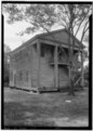 | 3,575 × 5,000 (17.05 MB) | Fæ | GWToolset: Creating mediafile for Fæ. HABS batch upload 29 June 2014 (101:150) |
Cysylltiadau'r ffeil
Mae'r 1 tudalennau a ddefnyddir isod yn cysylltu i'r ddelwedd hon:
Defnydd cydwici y ffeil
Mae'r wicis eraill hyn yn defnyddio'r ffeil hon:
- Y defnydd ar en.wikipedia.org
- Y defnydd ar fa.wikipedia.org
- Y defnydd ar www.wikidata.org
- Y defnydd ar zh.wikipedia.org