
Delwedd:Grundy County Courthouse (7395451684).jpg

Maint y rhagolwg: 800 × 600 picsel. Eglurdebau eraill: 320 × 240 picsel | 640 × 480 picsel | 1,024 × 768 picsel | 1,280 × 960 picsel | 2,560 × 1,920 picsel | 3,648 × 2,736 picsel.
Maint llawn ((3,648 × 2,736 picsel, maint y ffeil: 3.31 MB, ffurf MIME: image/jpeg))
.jpg)
| Camera location | | View this and other nearby images on: OpenStreetMap |
|---|
.jpg¶ms=041.356944_N_-088.423056_E_globe:Earth_type:camera__&language=cy)
| Disgrifiad |
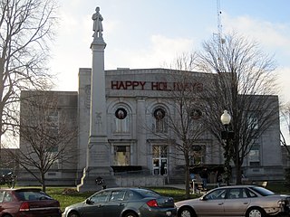
English: Front of the Grundy County Courthouse, located on the square bounded by Washington, Franklin, Illinois, and Liberty Streets in Morris, Illinois, United States. Built in 1913, it is a part of the Morris Downtown Commercial Historic District, a historic district that is listed on the National Register of Historic Places. Morris was selected as the Grundy County seat in 1841; the town was named after Isaac N. Morris, the president of the Illinois & Michigan Canal. This structure, the third county courthouse, was built in 1913. The granite structure in front is the Soldiers and Sailors Monument by Lorado Taft. Grundy County was founded in 1841, split off of LaSalle County. It was named for Felix Grundy, the Attorney General of the United States who died a few months earlier.
|
||
| Dyddiad | |||
| Ffynhonnell | Flickr | ||
| Awdur | Teemu08 | ||
| Caniatâd (Ailddefnyddio'r ffeil hon) |
Trwyddedir y ffeil hon yn ôl termau'r drwydded Creative Commons Attribution-Share Alike 2.0 Generic.
|
| This image, originally posted to Flickr, was reviewed on 8 November 2013 by the administrator or reviewer File Upload Bot (Magnus Manske), who confirmed that it was available on Flickr under the stated license on that date. |
Hanes y ffeil
Cliciwch ar ddyddiad / amser i weld y ffeil fel ag yr oedd bryd hynny.
| Dyddiad / Amser | Bawdlun | Hyd a lled | Defnyddiwr | Sylw | |
|---|---|---|---|---|---|
| cyfredol | 03:55, 8 Tachwedd 2013 | | 3,648 × 2,736 (3.31 MB) | File Upload Bot (Magnus Manske) | Transferred from Flickr by User:AlbertHerring |
Cysylltiadau'r ffeil
Mae'r 1 tudalennau a ddefnyddir isod yn cysylltu i'r ddelwedd hon:
Defnydd cydwici y ffeil
Mae'r wicis eraill hyn yn defnyddio'r ffeil hon:
- Y defnydd ar ar.wikipedia.org
- Y defnydd ar azb.wikipedia.org
- Y defnydd ar ceb.wikipedia.org
- Y defnydd ar ce.wikipedia.org
- Y defnydd ar de.wikipedia.org
- Y defnydd ar en.wikipedia.org
- Y defnydd ar eo.wikipedia.org
- Y defnydd ar es.wikipedia.org
- Y defnydd ar fa.wikipedia.org
- Y defnydd ar fr.wikipedia.org
- Y defnydd ar hu.wikipedia.org
- Y defnydd ar hy.wikipedia.org
- Y defnydd ar ko.wikipedia.org
- Y defnydd ar no.wikipedia.org
- Y defnydd ar pl.wikipedia.org
- Y defnydd ar pt.wikipedia.org
- Y defnydd ar ro.wikipedia.org
- Y defnydd ar ru.wikipedia.org
- Y defnydd ar sr.wikipedia.org
- Y defnydd ar sv.wikipedia.org
- Y defnydd ar tr.wikipedia.org
- Y defnydd ar tt.wikipedia.org
- Y defnydd ar ur.wikipedia.org
- Y defnydd ar www.wikidata.org
- Y defnydd ar zh-min-nan.wikipedia.org
.jpg)