
Delwedd:Deutsche Mundarten seit 1945.png

Maint y rhagolwg: 800 × 316 picsel. Eglurdebau eraill: 320 × 127 picsel | 640 × 253 picsel | 1,917 × 758 picsel.
Maint llawn ((1,917 × 758 picsel, maint y ffeil: 72 KB, ffurf MIME: image/png))

|
This linguistic map image could be re-created using vector graphics as an SVG file. This has several advantages; see Commons:Media for cleanup for more information. If an SVG form of this image is available, please upload it and afterwards replace this template with
{{vector version available|new image name}}.
It is recommended to name the SVG file “Deutsche Mundarten seit 1945.svg”—then the template Vector version available (or Vva) does not need the new image name parameter. |
Transferred from als.wikipedia to Commons by Maksim.
The original description page was here. All following user names refer to als.wikipedia.
Herkunft: Bild Deutsche Mundarten seit 1945.PNG aus der deutschen Wikipedia, von Benutzer Postmann Michael.
Folgende Angaben wurden von dort übernommen:
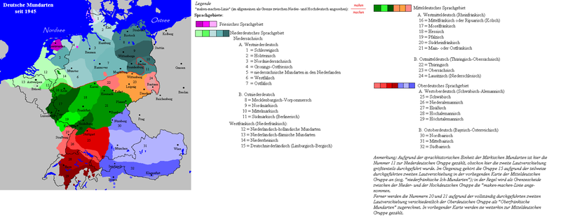
Gebiet der deutschen Mundarten seit Ende des 2. Weltkrieges.
- Beschreibung: Darstellungskarte zeigt die wichtigsten deutschen Mundarten der Gegenwart. Deutsche Außengrenze: 3. Oktober 1990.
- Zeichner: Postmann Michael
- erstellt am 14. Sept. 2004
- Quellen: Nach den Vorgaben des "Atlas" des Lingen-Verlages (1975) und dem "Großen Handlexikon in Farbe", Bertelsmann-Verlag (1979), sowie dem "dtv-Atlas zur deutschen Sprache", dtv-Verlag (9. Auflage;1992) wurde vorliegende Darstellungskarte angefertigt.
- Lizenzstatus: Public Domain
siehe auch/see also: Sprachenkarte aus dem aktuellen Meyers-Lexikon (übernommen vom Bertelsmann-Verlag) archive copy at the Wayback Machine----
| Cafodd y gwaith hwn ei ryddhau i'r parth cyhoeddus gan ei awdur, Postmann Michael at Almaeneg Wicipedia. Mae hyn yn weithredol ledled y byd. Hwyrach nad yw hyn yn bosib yn ôl cyfraith rhai gwledydd; os felly: Mae Postmann Michael yn rhoi i unrhywun yr hawl i ddefnyddio'r gwaith hwn at unrhyw ddiben, heb unrhyw amodau, oddieithr unrhyw amodau gofynnol yn ôl y gyfraith. |
Crynodeb
| Disgrifiad |
English: Map of the German dialects after 1945. Note that it is incorrect, e.g.:
Deutsch: Karte der deutschen Mundarten nach 1945. Inhaltlich fehlerhaft. |
| Dyddiad | 14. Sept. 2004 |
| Ffynhonnell |
Angefertigt nach:
|
| Awdur | Postmann Michael |
Hanes y ffeil
Cliciwch ar ddyddiad / amser i weld y ffeil fel ag yr oedd bryd hynny.
| Dyddiad / Amser | Bawdlun | Hyd a lled | Defnyddiwr | Sylw | |
|---|---|---|---|---|---|
| cyfredol | 18:39, 7 Gorffennaf 2009 | 1,917 × 758 (72 KB) | Badener | Lage von Karlsruhe korrigiert | |
| 16:42, 23 Mawrth 2007 | 1,917 × 758 (98 KB) | Gruna 1~commonswiki | correction around the Frisian-Groningan area - Bilts, Midlands, Gronings-Oostfries, enz. | ||
| 18:53, 24 Ionawr 2006 | 1,917 × 758 (100 KB) | Maksim | La bildo estas kopiita de wikipedia:als. La originala priskribo estas: '''Herkunft:''' Bild Deutsche Mundarten seit 1945.PNG aus der deutschen Wikipedia, von Benutzer Postmann Michael. Fol |
Cysylltiadau'r ffeil
Mae'r 1 tudalennau a ddefnyddir isod yn cysylltu i'r ddelwedd hon:
Defnydd cydwici y ffeil
Mae'r wicis eraill hyn yn defnyddio'r ffeil hon:
- Y defnydd ar de.wikipedia.org
- Y defnydd ar hr.wikipedia.org
- Y defnydd ar nl.wikipedia.org
- Y defnydd ar ro.wikipedia.org
- Y defnydd ar ru.wikipedia.org