
Delwedd:Welcome to Bardney - geograph.org.uk - 1243832.jpg
Maint llawn ((426 × 640 picsel, maint y ffeil: 93 KB, ffurf MIME: image/jpeg))
Crynodeb
| Disgrifiad |
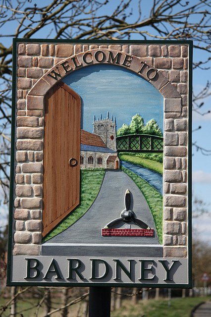
English: Welcome to Bardney, near to Bardney, Lincolnshire, Great Britain.
New Bardney village sign on Horncastle Road depicting Bardney Bridge <a title="https://www.geograph.org.uk/photo/517511" rel="nofollow" href="https://www.geograph.org.uk/photo/517511">Link</a><img style="padding-left:2px;" alt="External link" title="External link - shift click to open in new window" src="http://s0.geograph.org.uk/img/external.png" width="10" height="10"/> St.Lawrence's Church <a title="https://www.geograph.org.uk/photo/42589" rel="nofollow" href="https://www.geograph.org.uk/photo/42589">Link</a><img style="padding-left:2px;" alt="External link" title="External link - shift click to open in new window" src="http://s0.geograph.org.uk/img/external.png" width="10" height="10"/> and 9 Squadron Memorial <a title="https://www.geograph.org.uk/photo/954427" rel="nofollow" href="https://www.geograph.org.uk/photo/954427">Link</a><img style="padding-left:2px;" alt="External link" title="External link - shift click to open in new window" src="http://s0.geograph.org.uk/img/external.png" width="10" height="10"/> .... all viewed through an open door symbolising Bardney's most famous tale, recounted by the Venerable Bede |
| Dyddiad | |
| Ffynhonnell | From geograph.org.uk; transferred by User:LongLiveRock using geograph_org2commons. |
| Awdur | Richard Croft |
| Caniatâd (Ailddefnyddio'r ffeil hon) |
Creative Commons Attribution Share-alike license 2.0 |
| Camera location | | View this and other nearby images on: OpenStreetMap |
|---|
| Object location | | View this and other nearby images on: OpenStreetMap |
|---|
_region:GB-GBN_heading:315.00&language=cy)
Trwyddedu

|
This image was taken from the Geograph project collection. See this photograph's page on the Geograph website for the photographer's contact details. The copyright on this image is owned by Richard Croft and is licensed for reuse under the Creative Commons Attribution-ShareAlike 2.0 license.
|
- Mae'n rhydd i chi:
- rhannu – gallwch gopïo, dosbarthu a throsglwyddo'r gwaith
- ailwampio – gallwch addasu'r gwaith
- Ar yr amodau canlynol:
- cydnabyddiaeth – Mae'n rhaid i chi nodi manylion y gwaith hwn, rhoi dolen i'r drwydded, a nodi os y bu golygu arni, yn y modd a benwyd gan yr awdur neu'r trwyddedwr (ond heb awgrymu o gwbl eu bod yn eich cymeradwyo chi na'ch defnydd o'r gwaith).
- rhannu ar dermau tebyg – Os byddwch yn addasu'r gwaith hwn, neu yn ei drawsnewid, neu yn adeiladu arno, mae'n rhaid i chi ddosbarthu'r gwaith dan drwydded sy'n union yr un fath same a'r gwreiddiol.
Hanes y ffeil
Cliciwch ar ddyddiad / amser i weld y ffeil fel ag yr oedd bryd hynny.
| Dyddiad / Amser | Bawdlun | Hyd a lled | Defnyddiwr | Sylw | |
|---|---|---|---|---|---|
| cyfredol | 23:34, 19 Hydref 2010 | | 426 × 640 (93 KB) | File Upload Bot (Magnus Manske) |
Cysylltiadau'r ffeil
Mae'r 1 tudalennau a ddefnyddir isod yn cysylltu i'r ddelwedd hon:
Defnydd cydwici y ffeil
Mae'r wicis eraill hyn yn defnyddio'r ffeil hon:
- Y defnydd ar ceb.wikipedia.org
- Y defnydd ar en.wikipedia.org
- Y defnydd ar es.wikipedia.org
- Y defnydd ar fa.wikipedia.org
- Y defnydd ar fr.wikipedia.org
- Y defnydd ar lld.wikipedia.org
- Y defnydd ar pl.wikipedia.org
- Y defnydd ar www.wikidata.org