
Delwedd:Vatican City map EN.png

Maint y rhagolwg: 777 × 600 picsel. Eglurdebau eraill: 311 × 240 picsel | 622 × 480 picsel | 995 × 768 picsel | 1,280 × 988 picsel | 2,560 × 1,977 picsel | 2,888 × 2,230 picsel.
Maint llawn ((2,888 × 2,230 picsel, maint y ffeil: 2.41 MB, ffurf MIME: image/png))
Crynodeb
| Disgrifiad |
Deutsch: Karte der Vatikanstadt (englische Version)
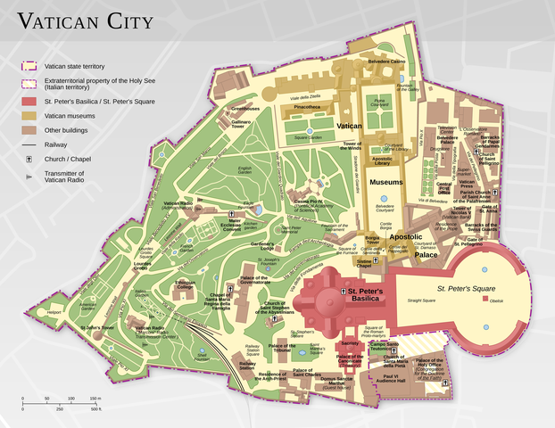
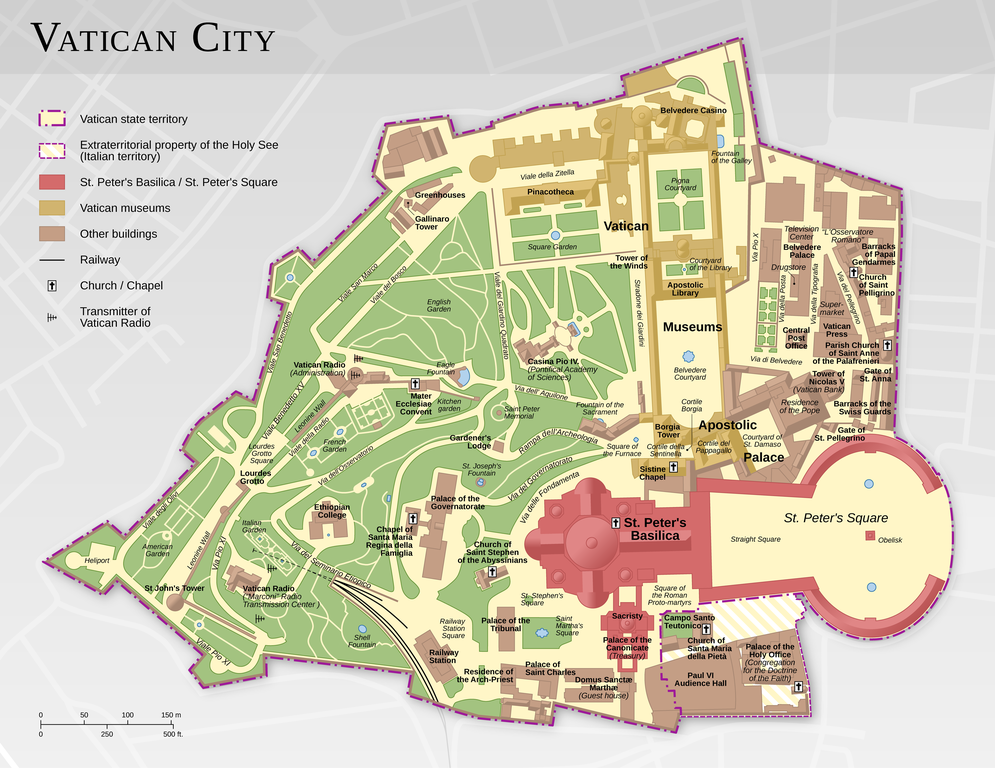
English: Map of the Vatican City (English version)
Español: Mapa de la Ciudad del Vaticano (versión en inglés).
Suomi: Vatikaanin kartta (englanninkielinen versio)
Français : Carte de la Cité du Vatican, à partir d'informations d'OpenStreetMap. Version en anglais ; voir la version en français ici : Vatican City map FR.png
中文:梵蒂冈城国地图(英语版本)
Bosanski: Karta Vatikana - sadrži kartografske podatke sa projekta ©OpenStreetMap (ODbL).
|
|||||||||
| Dyddiad | ||||||||||
| Ffynhonnell |
Gwaith yr uwchlwythwr |
|||||||||
| Crëwr | ||||||||||
| Caniatâd (Ailddefnyddio'r ffeil hon) |
|
|||||||||
| Geotemporal data | ||||||||||
| Bounding box |
|
|||||||||
| Georeferencing | ||||||||||
| Diwygiadau eraill |
|
|||||||||


|
This map has been made or improved in the German Kartenwerkstatt (Map Lab). You can propose maps to improve as well.
|
Trwyddedu
Trwyddedir y ffeil hon yn ôl termau'r drwydded Creative Commons Attribution-Share Alike 3.0 Unported.
Cydnabyddiaeth: Thomas Römer/OpenStreetMap data
- Mae'n rhydd i chi:
- rhannu – gallwch gopïo, dosbarthu a throsglwyddo'r gwaith
- ailwampio – gallwch addasu'r gwaith
- Ar yr amodau canlynol:
- cydnabyddiaeth – Mae'n rhaid i chi nodi manylion y gwaith hwn, rhoi dolen i'r drwydded, a nodi os y bu golygu arni, yn y modd a benwyd gan yr awdur neu'r trwyddedwr (ond heb awgrymu o gwbl eu bod yn eich cymeradwyo chi na'ch defnydd o'r gwaith).
- rhannu ar dermau tebyg – Os byddwch yn addasu'r gwaith hwn, neu yn ei drawsnewid, neu yn adeiladu arno, mae'n rhaid i chi ddosbarthu'r gwaith dan drwydded sy'n union yr un fath same a'r gwreiddiol.
Assessment
|

This image was selected as picture of the day on Wikimedia Commons for 11 February 2015. It was captioned as follows: Other languages:
Bosanski: Karta Vatikana - sadrži kartografske podatke sa projekta ©OpenStreetMap (ODbL). |
Hanes y ffeil
Cliciwch ar ddyddiad / amser i weld y ffeil fel ag yr oedd bryd hynny.
| Dyddiad / Amser | Bawdlun | Hyd a lled | Defnyddiwr | Sylw | |
|---|---|---|---|---|---|
| cyfredol | 11:44, 12 Chwefror 2021 | | 2,888 × 2,230 (2.41 MB) | Foghe | St. Damasco → St. Damaso. |
| 09:22, 11 Ebrill 2013 |  | 2,888 × 2,230 (2.14 MB) | Thoroe | larger render | |
| 17:12, 10 Ebrill 2013 |  | 1,733 × 1,338 (1.11 MB) | Thoroe | small fixes | |
| 15:59, 23 Mawrth 2013 |  | 1,733 × 1,338 (1.1 MB) | Thoroe | minor fixes | |
| 00:41, 23 Mawrth 2013 |  | 1,733 × 1,338 (1.09 MB) | Thoroe | {{Information |Description ={{en|1=Map of the Vatican City (English version)}} {{de|1=Karte der Vatikanstadt (englische Version)}} |Source ={{own}} *[http://www.vatican.va/news_services/press/docume... |
Cysylltiadau'r ffeil
Nid oes tudalennau'n defnyddio'r ffeil hon.
Defnydd cydwici y ffeil
Mae'r wicis eraill hyn yn defnyddio'r ffeil hon:
- Y defnydd ar af.wikipedia.org
- Y defnydd ar be-tarask.wikipedia.org
- Y defnydd ar ca.wikipedia.org
- Y defnydd ar crh.wikipedia.org
- Y defnydd ar cv.wikipedia.org
- Y defnydd ar de.wikipedia.org
- Y defnydd ar en.wikipedia.org
- Wikipedia:Featured pictures/Diagrams, drawings, and maps/Maps
- Talk:Vatican City/Archive 1
- User talk:Thoroe
- Wikipedia:Featured pictures thumbs/37
- User talk:Crisco 1492/Archive 44
- Wikipedia:Featured picture candidates/Vatican City map
- Wikipedia:Featured picture candidates/October-2013
- Wikipedia:Picture of the day/August 2015
- Template:POTD/2015-08-07
- Wikipedia:Main Page history/2015 August 7
- User:John Paul II/Line of Popes
- Portal:Geography/Selected picture
- User:ਕਰਨ 13/sandbox
- Y defnydd ar en.wikivoyage.org
- Y defnydd ar fo.wikipedia.org
- Y defnydd ar fr.wikipedia.org
- Y defnydd ar hu.wikipedia.org
- Y defnydd ar ka.wikipedia.org
- Y defnydd ar ko.wikipedia.org
- Y defnydd ar krc.wikipedia.org
- Y defnydd ar lbe.wikipedia.org
- Y defnydd ar www.mediawiki.org
- Y defnydd ar mg.wikipedia.org
- Y defnydd ar os.wikipedia.org
- Y defnydd ar pl.wikipedia.org
- Y defnydd ar pt.wikipedia.org
- Y defnydd ar ru.wikipedia.org
- Y defnydd ar ru.wikinews.org
- Y defnydd ar sah.wikipedia.org
- Y defnydd ar sv.wikipedia.org
- Y defnydd ar tr.wikipedia.org
- Y defnydd ar tt.wikipedia.org
Gweld rhagor o'r defnydd cydwici o'r ffeil hon.