
Delwedd:St Mark, Amcotts - geograph.org.uk - 423061.jpg
Wedi ei chwyddo hyd yr eithaf.
St_Mark,_Amcotts_-_geograph.org.uk_-_423061.jpg ((640 × 480 picsel, maint y ffeil: 70 KB, ffurf MIME: image/jpeg))
Crynodeb
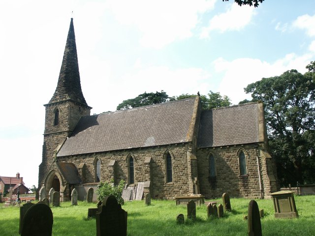
| Disgrifiad |
English: St Mark, Amcotts Standing near Flixborough and by the River Trent, the church of St Mark was built in the 1850s. The present building is the third to be built on the site. The foundation stone was laid on Tuesday 22nd October 1850 and was completed and dedicated to St Mark a year later, although the exact date is unknown. On 1st June 1974 the church was badly damaged with the Nypro explosion at Flixborough when the blast lifted the roof and dropped it again leaving a gap of 8 inches at the apex. The stained glass east window was completely blown in, there were cracks in the outer walls and it looked as though the church may have to be pulled down. Restoration did take place and although it also meant remaking the east window, the work was completed in two years. |
| Dyddiad | |
| Ffynhonnell | From geograph.org.uk |
| Awdur | Dave Hitchborne |
| Cydnabyddiaeth (required by the license) | Dave Hitchborne / St Mark, Amcotts / |
| Camera location | | View this and other nearby images on: OpenStreetMap |
|---|
_heading:315.00&language=cy)
| Object location | | View this and other nearby images on: OpenStreetMap |
|---|
_heading:315.00&language=cy)
Trwyddedu

|
This image was taken from the Geograph project collection. See this photograph's page on the Geograph website for the photographer's contact details. The copyright on this image is owned by Dave Hitchborne and is licensed for reuse under the Creative Commons Attribution-ShareAlike 2.0 license.
|
Trwyddedir y ffeil hon yn ôl termau'r drwydded Creative Commons Attribution-Share Alike 2.0 Generic.
Cydnabyddiaeth: Dave Hitchborne
- Mae'n rhydd i chi:
- rhannu – gallwch gopïo, dosbarthu a throsglwyddo'r gwaith
- ailwampio – gallwch addasu'r gwaith
- Ar yr amodau canlynol:
- cydnabyddiaeth – Mae'n rhaid i chi nodi manylion y gwaith hwn, rhoi dolen i'r drwydded, a nodi os y bu golygu arni, yn y modd a benwyd gan yr awdur neu'r trwyddedwr (ond heb awgrymu o gwbl eu bod yn eich cymeradwyo chi na'ch defnydd o'r gwaith).
- rhannu ar dermau tebyg – Os byddwch yn addasu'r gwaith hwn, neu yn ei drawsnewid, neu yn adeiladu arno, mae'n rhaid i chi ddosbarthu'r gwaith dan drwydded sy'n union yr un fath same a'r gwreiddiol.
Hanes y ffeil
Cliciwch ar ddyddiad / amser i weld y ffeil fel ag yr oedd bryd hynny.
| Dyddiad / Amser | Bawdlun | Hyd a lled | Defnyddiwr | Sylw | |
|---|---|---|---|---|---|
| cyfredol | 05:35, 4 Chwefror 2011 | | 640 × 480 (70 KB) | GeographBot | == {{int:filedesc}} == {{Information |description={{en|1=St Mark, Amcotts Standing near Flixborough and by the River Trent, the church of St Mark was built in the 1850s. The present building is the third to be built on the site. The foundation stone was |
Cysylltiadau'r ffeil
Mae'r 1 tudalennau a ddefnyddir isod yn cysylltu i'r ddelwedd hon:
Defnydd cydwici y ffeil
Mae'r wicis eraill hyn yn defnyddio'r ffeil hon:
- Y defnydd ar ceb.wikipedia.org
- Y defnydd ar en.wikipedia.org
- Y defnydd ar fr.wikipedia.org
- Y defnydd ar lld.wikipedia.org
- Y defnydd ar nl.wikipedia.org
- Y defnydd ar pl.wikipedia.org
- Y defnydd ar www.wikidata.org