
Delwedd:St Helen, East Keal - geograph.org.uk - 430623.jpg
Wedi ei chwyddo hyd yr eithaf.
St_Helen,_East_Keal_-_geograph.org.uk_-_430623.jpg ((640 × 480 picsel, maint y ffeil: 138 KB, ffurf MIME: image/jpeg))
Crynodeb
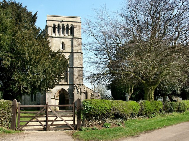
| Disgrifiad |
English: St Helen, East Keal The church of St Helen at East Keal, like that of St Helen at West Keal, stands on the very southern edge of the Wolds. It was almost entirely rebuilt in 1854 leaving just the south arcade, 13th-century and the north arcade, 14th-century. The octagonal 14th-century font has carvings flowers, leaves, grotesque heads and a bare backside!
In the south aisle, there is a small Elizabethan tablet inscribed Susanna Kirkman, which shows a seated figure, elbow resting on a skull with an extinguished torch in her other hand. There is also a bust of Peter Short who died in 1681. |
| Dyddiad | |
| Ffynhonnell | From geograph.org.uk |
| Awdur | Dave Hitchborne |
| Cydnabyddiaeth (required by the license) | Dave Hitchborne / St Helen, East Keal / |
| Camera location | | View this and other nearby images on: OpenStreetMap |
|---|
_heading:90.00&language=cy)
| Object location | | View this and other nearby images on: OpenStreetMap |
|---|
_heading:90.00&language=cy)
Trwyddedu

|
This image was taken from the Geograph project collection. See this photograph's page on the Geograph website for the photographer's contact details. The copyright on this image is owned by Dave Hitchborne and is licensed for reuse under the Creative Commons Attribution-ShareAlike 2.0 license.
|
Trwyddedir y ffeil hon yn ôl termau'r drwydded Creative Commons Attribution-Share Alike 2.0 Generic.
Cydnabyddiaeth: Dave Hitchborne
- Mae'n rhydd i chi:
- rhannu – gallwch gopïo, dosbarthu a throsglwyddo'r gwaith
- ailwampio – gallwch addasu'r gwaith
- Ar yr amodau canlynol:
- cydnabyddiaeth – Mae'n rhaid i chi nodi manylion y gwaith hwn, rhoi dolen i'r drwydded, a nodi os y bu golygu arni, yn y modd a benwyd gan yr awdur neu'r trwyddedwr (ond heb awgrymu o gwbl eu bod yn eich cymeradwyo chi na'ch defnydd o'r gwaith).
- rhannu ar dermau tebyg – Os byddwch yn addasu'r gwaith hwn, neu yn ei drawsnewid, neu yn adeiladu arno, mae'n rhaid i chi ddosbarthu'r gwaith dan drwydded sy'n union yr un fath same a'r gwreiddiol.
Hanes y ffeil
Cliciwch ar ddyddiad / amser i weld y ffeil fel ag yr oedd bryd hynny.
| Dyddiad / Amser | Bawdlun | Hyd a lled | Defnyddiwr | Sylw | |
|---|---|---|---|---|---|
| cyfredol | 09:02, 4 Chwefror 2011 | | 640 × 480 (138 KB) | GeographBot | == {{int:filedesc}} == {{Information |description={{en|1=St Helen, East Keal The church of St Helen at East Keal, like that of St Helen at West Keal, stands on the very southern edge of the Wolds. It was almost entirely rebuilt in 1854 leaving just the so |
Cysylltiadau'r ffeil
Mae'r 1 tudalennau a ddefnyddir isod yn cysylltu i'r ddelwedd hon:
Defnydd cydwici y ffeil
Mae'r wicis eraill hyn yn defnyddio'r ffeil hon:
- Y defnydd ar ceb.wikipedia.org
- Y defnydd ar en.wikipedia.org
- Y defnydd ar fa.wikipedia.org
- Y defnydd ar fr.wikipedia.org
- Y defnydd ar it.wikipedia.org
- Y defnydd ar lld.wikipedia.org
- Y defnydd ar nl.wikipedia.org
- Y defnydd ar sv.wikipedia.org
- Y defnydd ar www.wikidata.org