
Delwedd:St. John, U.S. Virgin Islands.jpg

Maint y rhagolwg: 600 × 600 picsel. Eglurdebau eraill: 240 × 240 picsel | 480 × 480 picsel | 768 × 768 picsel | 1,024 × 1,024 picsel | 2,400 × 2,400 picsel.
Maint llawn ((2,400 × 2,400 picsel, maint y ffeil: 2.74 MB, ffurf MIME: image/jpeg))
Crynodeb
| Disgrifiad |
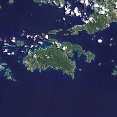
English: Natural-colour image of the Island of St. John island in the United States Virgin Islands.
|
| Dyddiad | |
| Ffynhonnell | NASA Earth Observatory |
| Awdur | Jesse Allen and Robert Simmon |
| Diwygiadau eraill |


.jpg)

Image captured by the Advanced Land Imager (ALI) on NASA’s Earth Observing-1 (EO-1) satellite. EO-1 ALI data provided courtesy of the NASA EO-1 team.
Trwyddedu
| This file is in the public domain in the United States because it was solely created by NASA. NASA copyright policy states that "NASA material is not protected by copyright unless noted". (See Template:PD-USGov, NASA copyright policy page or JPL Image Use Policy.) | ||
 |
Warnings:
|
| Annotations | This image is annotated: View the annotations at Commons |
Hanes y ffeil
Cliciwch ar ddyddiad / amser i weld y ffeil fel ag yr oedd bryd hynny.
| Dyddiad / Amser | Bawdlun | Hyd a lled | Defnyddiwr | Sylw | |
|---|---|---|---|---|---|
| cyfredol | 10:13, 20 Ionawr 2011 | | 2,400 × 2,400 (2.74 MB) | Originalwana | {{Information |Description={{en|1=Natural-colour image of the eastern half of St. John. Settlements—marked by curving roads and light roofs—line the irregular coastline. The pinpoints of white in Coral Bay are probably boats. The island’s interior |
Cysylltiadau'r ffeil
Mae'r 1 tudalennau a ddefnyddir isod yn cysylltu i'r ddelwedd hon:
Defnydd cydwici y ffeil
Mae'r wicis eraill hyn yn defnyddio'r ffeil hon:
- Y defnydd ar arz.wikipedia.org
- Y defnydd ar ast.wikipedia.org
- Y defnydd ar ca.wikipedia.org
- Y defnydd ar ceb.wikipedia.org
- Y defnydd ar en.wikipedia.org
- Y defnydd ar en.wikisource.org
- Y defnydd ar eo.wikipedia.org
- Y defnydd ar es.wikipedia.org
- Y defnydd ar eu.wikipedia.org
- Y defnydd ar fi.wikipedia.org
- Y defnydd ar frr.wikipedia.org
- Y defnydd ar fr.wikivoyage.org
- Y defnydd ar gl.wikipedia.org
- Y defnydd ar id.wikipedia.org
- Y defnydd ar lb.wikipedia.org
- Y defnydd ar pl.wikipedia.org
- Y defnydd ar tg.wikipedia.org
- Y defnydd ar tl.wikipedia.org
- Y defnydd ar uk.wikipedia.org
- Y defnydd ar vec.wikipedia.org
- Y defnydd ar www.wikidata.org