
Delwedd:Pechora.jpg

Maint y rhagolwg: 463 × 599 picsel. Eglurdebau eraill: 185 × 240 picsel | 371 × 480 picsel | 593 × 768 picsel | 791 × 1,024 picsel | 1,700 × 2,200 picsel.
Maint llawn ((1,700 × 2,200 picsel, maint y ffeil: 803 KB, ffurf MIME: image/jpeg))
Crynodeb
| Disgrifiad |
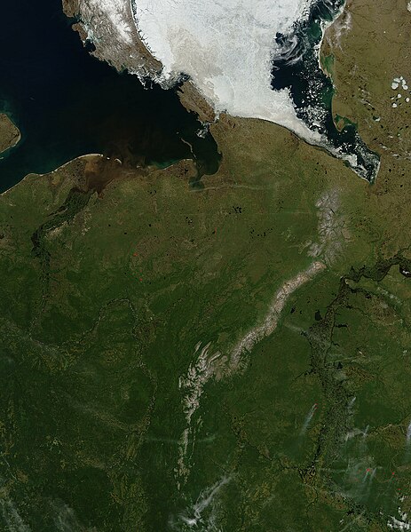
English: Pechora River
sattelite photo On July 3, 2004, sea ice still covered much of the Kara Sea in Northeastern Russia, near the western edge of Siberia, when the Moderate Resolution Imaging Spectroradiometer (MODIS) on NASA’s Aqua satellite captured this image. The southern tip of Novaya Zemlya Island curves out of the upper left corner of the image and is separated from Vaygach Island by Karskiye Vorota Strait. The narrow Yugorskiy Shar Strait, which separates Vaygach Island from mainland Russia, is clogged with sea ice. To the west, image left, the Pechora River is emptying brown, sediment-rich water into the Pechorskoye Sea. The water is probably loaded with mud as the far north thaws for the summer. In the lower right corner of the image, MODIS has detected a handful of fires, marked in red, which are sending light plumes of smoke to the southwest. |
| Ffynhonnell | Gwaith yr uwchlwythwr |
| Awdur | user:Svart |
Trwyddedu
| This file is in the public domain in the United States because it was solely created by NASA. NASA copyright policy states that "NASA material is not protected by copyright unless noted". (See Template:PD-USGov, NASA copyright policy page or JPL Image Use Policy.) | ||
 |
Warnings:
|
Hanes y ffeil
Cliciwch ar ddyddiad / amser i weld y ffeil fel ag yr oedd bryd hynny.
| Dyddiad / Amser | Bawdlun | Hyd a lled | Defnyddiwr | Sylw | |
|---|---|---|---|---|---|
| cyfredol | 21:47, 27 Mawrth 2006 | | 1,700 × 2,200 (803 KB) | Svart~commonswiki | '''Pechora River''' sattelite photo On July 3, 2004, sea ice still covered much of the Kara Sea in Northeastern Russia, near the western edge of Siberia, when the Moderate Resolution Imaging Spectroradiometer (MODIS) on NASA’s Aqua satellite captured |
Cysylltiadau'r ffeil
Nid oes tudalennau'n defnyddio'r ffeil hon.
Defnydd cydwici y ffeil
Mae'r wicis eraill hyn yn defnyddio'r ffeil hon:
- Y defnydd ar af.wikipedia.org
- Y defnydd ar ar.wikipedia.org
- Y defnydd ar arz.wikipedia.org
- Y defnydd ar ast.wikipedia.org
- Y defnydd ar az.wikipedia.org
- Y defnydd ar be.wikipedia.org
- Y defnydd ar bg.wikipedia.org
- Y defnydd ar bn.wikipedia.org
- Y defnydd ar ca.wikipedia.org
- Y defnydd ar ceb.wikipedia.org
- Y defnydd ar ce.wikipedia.org
- Y defnydd ar de.wikivoyage.org
- Y defnydd ar diq.wikipedia.org
- Y defnydd ar en.wikipedia.org
- Y defnydd ar eo.wikipedia.org
- Y defnydd ar es.wikipedia.org
- Y defnydd ar eu.wikipedia.org
- Y defnydd ar fi.wikipedia.org
- Y defnydd ar fr.wikivoyage.org
- Y defnydd ar ga.wikipedia.org
- Y defnydd ar gl.wikipedia.org
- Y defnydd ar he.wikipedia.org
- Y defnydd ar hy.wikipedia.org
- Y defnydd ar id.wikipedia.org
- Y defnydd ar lmo.wikipedia.org
- Y defnydd ar lv.wikipedia.org
- Y defnydd ar mhr.wikipedia.org
- Y defnydd ar mrj.wikipedia.org
Gweld rhagor o'r defnydd cydwici o'r ffeil hon.