
Delwedd:New sign marking the eastern boundary of Haigh - geograph.org.uk - 1045584.jpg
Wedi ei chwyddo hyd yr eithaf.
New_sign_marking_the_eastern_boundary_of_Haigh_-_geograph.org.uk_-_1045584.jpg ((640 × 426 picsel, maint y ffeil: 59 KB, ffurf MIME: image/jpeg))
Crynodeb
| Disgrifiad |
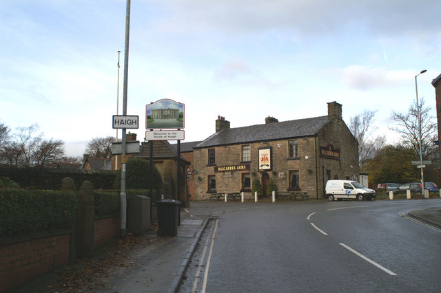
English: New sign marking the eastern boundary of Haigh This type of pictorial sign is being erected around Wigan Borough, largely at the request of local people, to mark the many separate communities, often old mining villages originally, which make up the modern Metropolitan Borough. The design is also often chosen after local consultation. Some show more imagination than others. Many share a common fault - the posts to which they are fixed straddle part of the pavement. They are too narrow to allow easy access between the posts, and yet are wide enough to leave inadequate space on the rest of the pavement for, say, a mother with a pram. Mothers bringing children to St David's School, to the left of the pub, may well have discovered this by now. |
| Dyddiad | |
| Ffynhonnell | From geograph.org.uk |
| Awdur | David Long |
| Cydnabyddiaeth (required by the license) | David Long / New sign marking the eastern boundary of Haigh / |
| Camera location | | View this and other nearby images on: OpenStreetMap |
|---|
_heading:292.00&language=cy)
| Object location | | View this and other nearby images on: OpenStreetMap |
|---|
_heading:292.00&language=cy)
Trwyddedu

|
This image was taken from the Geograph project collection. See this photograph's page on the Geograph website for the photographer's contact details. The copyright on this image is owned by David Long and is licensed for reuse under the Creative Commons Attribution-ShareAlike 2.0 license.
|
Trwyddedir y ffeil hon yn ôl termau'r drwydded Creative Commons Attribution-Share Alike 2.0 Generic.
Cydnabyddiaeth: David Long
- Mae'n rhydd i chi:
- rhannu – gallwch gopïo, dosbarthu a throsglwyddo'r gwaith
- ailwampio – gallwch addasu'r gwaith
- Ar yr amodau canlynol:
- cydnabyddiaeth – Mae'n rhaid i chi nodi manylion y gwaith hwn, rhoi dolen i'r drwydded, a nodi os y bu golygu arni, yn y modd a benwyd gan yr awdur neu'r trwyddedwr (ond heb awgrymu o gwbl eu bod yn eich cymeradwyo chi na'ch defnydd o'r gwaith).
- rhannu ar dermau tebyg – Os byddwch yn addasu'r gwaith hwn, neu yn ei drawsnewid, neu yn adeiladu arno, mae'n rhaid i chi ddosbarthu'r gwaith dan drwydded sy'n union yr un fath same a'r gwreiddiol.
Hanes y ffeil
Cliciwch ar ddyddiad / amser i weld y ffeil fel ag yr oedd bryd hynny.
| Dyddiad / Amser | Bawdlun | Hyd a lled | Defnyddiwr | Sylw | |
|---|---|---|---|---|---|
| cyfredol | 21:55, 23 Chwefror 2011 | | 640 × 426 (59 KB) | GeographBot | == {{int:filedesc}} == {{Information |description={{en|1=New sign marking the eastern boundary of Haigh This type of pictorial sign is being erected around Wigan Borough, largely at the request of local people, to mark the many separate communities, often |
Cysylltiadau'r ffeil
Mae'r 1 tudalennau a ddefnyddir isod yn cysylltu i'r ddelwedd hon:
Defnydd cydwici y ffeil
Mae'r wicis eraill hyn yn defnyddio'r ffeil hon:
- Y defnydd ar ceb.wikipedia.org
- Y defnydd ar en.wikipedia.org
- Y defnydd ar fa.wikipedia.org
- Y defnydd ar lld.wikipedia.org
- Y defnydd ar www.wikidata.org