
Delwedd:Merrill Lock 6 Landing.jpg

Maint y rhagolwg: 450 × 600 picsel. Eglurdebau eraill: 180 × 240 picsel | 360 × 480 picsel | 576 × 768 picsel | 768 × 1,024 picsel | 2,112 × 2,816 picsel.
Maint llawn ((2,112 × 2,816 picsel, maint y ffeil: 2.69 MB, ffurf MIME: image/jpeg))
|
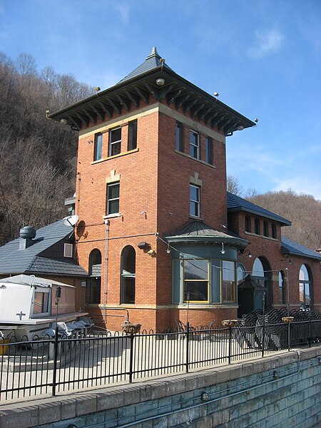
This is an image of a place or building that is listed on the National Register of Historic Places in the United States of America. Its reference number is 80003410. |
| Camera location | | View this and other nearby images on: OpenStreetMap |
|---|
| Disgrifiad |
English: Southwestern front of the former powerhouse at the Merrill Lock No. 6, located along the Ohio River at Industry in Beaver County, Pennsylvania, United States. The lock and its associated dam and buildings were completed in 1906 and superseded in 1936. The Romanesque powerhouse (the larger of the two buildings at the site) currently serves as the location of a restaurant; it is listed on the National Register of Historic Places. |
||
| Dyddiad | Taken on 11 Ebrill 2009 | ||
| Ffynhonnell | Gwaith yr uwchlwythwr | ||
| Awdur | Nyttend | ||
| Caniatâd (Ailddefnyddio'r ffeil hon) |
|
Hanes y ffeil
Cliciwch ar ddyddiad / amser i weld y ffeil fel ag yr oedd bryd hynny.
| Dyddiad / Amser | Bawdlun | Hyd a lled | Defnyddiwr | Sylw | |
|---|---|---|---|---|---|
| cyfredol | 22:04, 11 Ebrill 2009 | | 2,112 × 2,816 (2.69 MB) | Nyttend | {{Location|40|40|7|N|80|21|6|W}} {{Information |Description={{en|Southwestern front of the former pumphouse at the {{w|Merrill Lock No. 6}}, located along the {{w|Ohio River}} at {{w|Industry, Pennsylvania|Industry}} in {{w|Beaver County, Pennsylvania|Bea |
| 22:02, 11 Ebrill 2009 |  | 2,816 × 2,112 (2.69 MB) | Nyttend | {{Location|40|40|7|N|80|21|6|W}} {{Information |Description={{en|Southwestern front of the former pumphouse at the {{w|Merrill Lock No. 6}}, located along the {{w|Ohio River}} at {{w|Industry, Pennsylvania|Industry}} in {{w|Beaver County, Pennsylvania|Bea | |
| 21:19, 11 Ebrill 2009 |  | 2,816 × 2,112 (2.69 MB) | Nyttend | {{Location|40|40|7|N|80|21|6|W}} {{Information |Description={{en|Southwestern front of the former pumphouse at the {{w|Merrill Lock No. 6}}, located along the {{w|Ohio River}} at {{w|Industry, Pennsylvania|Industry}} in {{w|Beaver County, Pennsylvania|Bea |
Cysylltiadau'r ffeil
Mae'r 1 tudalennau a ddefnyddir isod yn cysylltu i'r ddelwedd hon:
Defnydd cydwici y ffeil
Mae'r wicis eraill hyn yn defnyddio'r ffeil hon:
- Y defnydd ar ca.wikipedia.org
- Y defnydd ar ceb.wikipedia.org
- Y defnydd ar ce.wikipedia.org
- Y defnydd ar de.wikipedia.org
- Y defnydd ar en.wikipedia.org
- Industry, Pennsylvania
- National Register of Historic Places listings in Beaver County, Pennsylvania
- Merrill Lock No. 6
- Wikipedia:Recent additions/2009/April
- User talk:Doncram/Archive 8
- Portal:Pennsylvania/Did you know/24
- Portal:Pennsylvania/Did you know
- User:Nyttend/DYK
- User talk:Dthomsen8/List PA Test
- Y defnydd ar es.wikipedia.org
- Y defnydd ar eu.wikipedia.org
- Y defnydd ar fr.wikipedia.org
- Y defnydd ar ht.wikipedia.org
- Y defnydd ar it.wikipedia.org
- Y defnydd ar lld.wikipedia.org
- Y defnydd ar pt.wikipedia.org
- Y defnydd ar sh.wikipedia.org
- Y defnydd ar sr.wikipedia.org
- Y defnydd ar tl.wikipedia.org
- Y defnydd ar tr.wikipedia.org
- Y defnydd ar tt.wikipedia.org
- Y defnydd ar uk.wikipedia.org
- Y defnydd ar ur.wikipedia.org
- Y defnydd ar uz.wikipedia.org
- Y defnydd ar vi.wikipedia.org
- Y defnydd ar www.wikidata.org
- Y defnydd ar zh-min-nan.wikipedia.org