
Delwedd:Kuster Mill.JPG

Maint y rhagolwg: 800 × 600 picsel. Eglurdebau eraill: 320 × 240 picsel | 640 × 480 picsel | 1,024 × 768 picsel | 1,280 × 960 picsel | 2,560 × 1,920 picsel | 4,271 × 3,203 picsel.
Maint llawn ((4,271 × 3,203 picsel, maint y ffeil: 4.48 MB, ffurf MIME: image/jpeg))
|
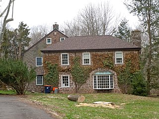
This is an image of a place or building that is listed on the National Register of Historic Places in the United States of America. Its reference number is 71000711. |
Crynodeb
| Disgrifiad |
English: Kuster Mill on the NRHP since March 24, 1971. On Skippack Creek at Mill Road and Water Street Road, in Montgomery County, Pennsylvania south of Collegeville. A pedestrian bridge (now being repaired) leads into Evansburg State Park. Note that there is a Kuyster Mill in the park (on the other side of the creek to the west), but that this IS the Kuster Mill - it might also be called the Custer Mill because the family changed the spelling of the name. built in 1702, sold to Hermanus Custer in 1706, expanded by John Custer 1767. A later fulling mill was built, then burned down in 1936. It has been reconstructed and may be th part with the hipped roof shown in front here. |
| Dyddiad | |
| Ffynhonnell | Gwaith yr uwchlwythwr |
| Awdur | Smallbones |
| Camera location | | View this and other nearby images on: OpenStreetMap |
|---|
Trwyddedu
Yr wyf fi, deiliad yr hawlfraint ar y gwaith hwn, yn ei gyhoeddi yn ôl termau'r drwydded a ganlyn:
| Trwyddedir y ffeil hon yn ôl termau'r drwydded Creative Commons CC0 1.0 Universal Public Domain Dedication. | |
| Wrth gysylltu rhyw waith â'r weithred gyfreithiol hon, mae'r person a'i gysylltodd wedi ei gyflwyno i'r parth cyhoeddus gan ildio pob hawl cyfraith hawlfraint arno yn fydeang, gan gynnwys pob hawl perthynol a chyfagos, hyd eithaf y gyfraith. Gallwch gopïo, addasu, dosbarthu a pherfformio'r gwaith, hyd yn oed at bwrpas masnachol, a hynny oll heb ofyn caniatad.
|
Hanes y ffeil
Cliciwch ar ddyddiad / amser i weld y ffeil fel ag yr oedd bryd hynny.
| Dyddiad / Amser | Bawdlun | Hyd a lled | Defnyddiwr | Sylw | |
|---|---|---|---|---|---|
| cyfredol | 18:19, 8 Ebrill 2011 | | 4,271 × 3,203 (4.48 MB) | Smallbones | {{Information |Description ={{en|1=Kuster Mill on the NRHP since March 24, 1971. On Skippack Creek at Mill Road and Water Street Road, in Montgomery County, Pennsylvania south of Collegeville. A pedestrian bridge (now being repaired) leads into Evansb |
Cysylltiadau'r ffeil
Mae'r 1 tudalennau a ddefnyddir isod yn cysylltu i'r ddelwedd hon:
Defnydd cydwici y ffeil
Mae'r wicis eraill hyn yn defnyddio'r ffeil hon:
- Y defnydd ar en.wikipedia.org
- Y defnydd ar en.wikivoyage.org
- Y defnydd ar es.wikipedia.org
- Y defnydd ar fr.wikipedia.org
- Y defnydd ar it.wikipedia.org
- Y defnydd ar simple.wikipedia.org
- Y defnydd ar uk.wikipedia.org
- Y defnydd ar vi.wikipedia.org
- Y defnydd ar www.wikidata.org