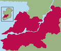
Delwedd:Kingdom of Thomond.png
Gwedd

Maint y rhagolwg: 800 × 462 picsel. Eglurdebau eraill: 320 × 185 picsel | 640 × 369 picsel | 1,024 × 591 picsel | 1,655 × 955 picsel.
Maint llawn ((1,655 × 955 picsel, maint y ffeil: 137 KB, ffurf MIME: image/png))
Hanes y ffeil
Cliciwch ar ddyddiad / amser i weld y ffeil fel ag yr oedd bryd hynny.
| Dyddiad / Amser | Bawdlun | Hyd a lled | Defnyddiwr | Sylw | |
|---|---|---|---|---|---|
| cyfredol | 18:24, 7 Rhagfyr 2021 |  | 1,655 × 955 (137 KB) | SKIBLY101 | much more realistic map... to the west are uí fidgenti, to the south the deisis and the east are o'carroll ely, why dont you give an actual source before challenging this instead of drawing arbitrary lines based on nothing |
| 20:48, 20 Mehefin 2009 |  | 539 × 449 (30 KB) | Thomas Gun | colour | |
| 06:24, 19 Ebrill 2009 |  | 539 × 449 (32 KB) | Thomas Gun | colour | |
| 08:07, 29 Rhagfyr 2008 |  | 539 × 449 (36 KB) | Thomod | {{Information |Description= |Source= |Date= |Author= |Permission= |other_versions= }} | |
| 08:04, 29 Rhagfyr 2008 |  | 539 × 449 (36 KB) | Thomod | {{Information |Description= |Source= |Date= |Author= |Permission= |other_versions= }} | |
| 08:01, 29 Rhagfyr 2008 |  | 539 × 449 (36 KB) | Thomod | {{Information |Description= |Source= |Date= |Author= |Permission= |other_versions= }} | |
| 07:54, 29 Rhagfyr 2008 |  | 539 × 449 (36 KB) | Thomod | {{Information |Description= |Source= |Date= |Author= |Permission= |other_versions= }} | |
| 10:34, 26 Rhagfyr 2008 |  | 357 × 430 (37 KB) | Thomod | {{Information |Description= Rough map of the Kingdom of Thomond. Most sources describe it as in the area of the modern day Diocese of Killaloe, this is the boundaries which have been used |Source=myself |Date=26 December 2008 |Author=self-created |Permiss | |
| 10:13, 26 Rhagfyr 2008 |  | 357 × 430 (38 KB) | Thomod | {{Information |Description= Rough map of the Kingdom of Thomond. Most sources describe it as in the area of the modern day Diocese of Killaloe, this is the boundaries which have been used |Source=myself |Date=26 December 2008 |Author=self-created |Permiss |
Cysylltiadau'r ffeil
Nid oes tudalennau'n defnyddio'r ffeil hon.
Defnydd cydwici y ffeil
Mae'r wicis eraill hyn yn defnyddio'r ffeil hon:
- Y defnydd ar ca.wikipedia.org
- Y defnydd ar de.wikipedia.org
- Y defnydd ar en.wikipedia.org
- Y defnydd ar es.wikipedia.org
- Y defnydd ar eu.wikipedia.org
- Y defnydd ar fr.wikipedia.org
- Y defnydd ar ga.wikipedia.org
- Y defnydd ar id.wikipedia.org
- Y defnydd ar it.wikipedia.org
- Y defnydd ar ko.wikipedia.org
- Y defnydd ar no.wikipedia.org
- Y defnydd ar ru.wikipedia.org
- Y defnydd ar uk.wikipedia.org
- Y defnydd ar www.wikidata.org
