
Delwedd:High Street, Bramley opposite the Library - geograph.org.uk - 527410.jpg
Wedi ei chwyddo hyd yr eithaf.
High_Street,_Bramley_opposite_the_Library_-_geograph.org.uk_-_527410.jpg ((640 × 519 picsel, maint y ffeil: 127 KB, ffurf MIME: image/jpeg))
Crynodeb
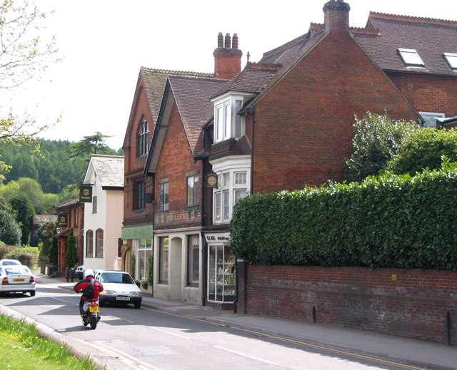
| Disgrifiad |
English: High Street, Bramley opposite the Library The tall Victorian building is the site of the Bramley Brewery, owned by the Smith family. Beer was brewed on this site from 1865 by William Smith. In 1901 his son Morton Smith was listed on the census as brewer and jeweller. In 1904 it was bought by Brufords of Cranleigh and in 1917 it was taken over by Cobham United Breweries.
Further down, still visible in the photo, was the Foundry also owned by the Smith family. Charles Smith, William's father bought the foundry in 1847. |
| Dyddiad | |
| Ffynhonnell | From geograph.org.uk |
| Awdur | Clare |
| Cydnabyddiaeth (required by the license) | Clare / High Street, Bramley opposite the Library / |
| Camera location | | View this and other nearby images on: OpenStreetMap |
|---|
_heading:180.00&language=cy)
| Object location | | View this and other nearby images on: OpenStreetMap |
|---|
_heading:180.00&language=cy)
Trwyddedu

|
This image was taken from the Geograph project collection. See this photograph's page on the Geograph website for the photographer's contact details. The copyright on this image is owned by Clare and is licensed for reuse under the Creative Commons Attribution-ShareAlike 2.0 license.
|
Trwyddedir y ffeil hon yn ôl termau'r drwydded Creative Commons Attribution-Share Alike 2.0 Generic.
Cydnabyddiaeth: Clare
- Mae'n rhydd i chi:
- rhannu – gallwch gopïo, dosbarthu a throsglwyddo'r gwaith
- ailwampio – gallwch addasu'r gwaith
- Ar yr amodau canlynol:
- cydnabyddiaeth – Mae'n rhaid i chi nodi manylion y gwaith hwn, rhoi dolen i'r drwydded, a nodi os y bu golygu arni, yn y modd a benwyd gan yr awdur neu'r trwyddedwr (ond heb awgrymu o gwbl eu bod yn eich cymeradwyo chi na'ch defnydd o'r gwaith).
- rhannu ar dermau tebyg – Os byddwch yn addasu'r gwaith hwn, neu yn ei drawsnewid, neu yn adeiladu arno, mae'n rhaid i chi ddosbarthu'r gwaith dan drwydded sy'n union yr un fath same a'r gwreiddiol.
Hanes y ffeil
Cliciwch ar ddyddiad / amser i weld y ffeil fel ag yr oedd bryd hynny.
| Dyddiad / Amser | Bawdlun | Hyd a lled | Defnyddiwr | Sylw | |
|---|---|---|---|---|---|
| cyfredol | 16:28, 5 Chwefror 2011 | | 640 × 519 (127 KB) | GeographBot | == {{int:filedesc}} == {{Information |description={{en|1=High Street, Bramley opposite the Library The tall Victorian building is the site of the Bramley Brewery, owned by the Smith family. Beer was brewed on this site from 1865 by William Smith. In 1901 |
Cysylltiadau'r ffeil
Mae'r 1 tudalennau a ddefnyddir isod yn cysylltu i'r ddelwedd hon:
Defnydd cydwici y ffeil
Mae'r wicis eraill hyn yn defnyddio'r ffeil hon:
- Y defnydd ar azb.wikipedia.org
- Y defnydd ar ceb.wikipedia.org
- Y defnydd ar en.wikipedia.org
- Y defnydd ar es.wikipedia.org
- Y defnydd ar fa.wikipedia.org
- Y defnydd ar fr.wikipedia.org
- Y defnydd ar id.wikipedia.org
- Y defnydd ar lld.wikipedia.org
- Y defnydd ar no.wikipedia.org
- Y defnydd ar pl.wikipedia.org
- Y defnydd ar www.wikidata.org
- Y defnydd ar zh-min-nan.wikipedia.org