
Delwedd:Great Bavington village centre - geograph.org.uk - 1176848.jpg
Wedi ei chwyddo hyd yr eithaf.
Great_Bavington_village_centre_-_geograph.org.uk_-_1176848.jpg ((640 × 480 picsel, maint y ffeil: 83 KB, ffurf MIME: image/jpeg))
Crynodeb
| Disgrifiad |
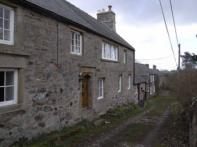
English: Great Bavington village centre These buildings stand at the very centre of Great Bavington which at one time was a much larger place than it is today. The house in the foreground is the oldest building still standing in the village and was built in 1625. The nearer part was once the "Harvest Home" public house, and subsequently the manse for the United Reformed Church across the way before being superseded by the new manse of 1854 adjacent to the Church.
The far end of the building housed the village school from 1855 until 1946. From 1949 the school building housed a Youth Hostel but it was closed in 1959 because of "unseemly behaviour" by the hostellers - what ever can that mean? The building is now divided into two private houses - Easter House (nearest the camera) and Easter Cottage. |
| Dyddiad | |
| Ffynhonnell | From geograph.org.uk |
| Awdur | Oliver Dixon |
| Cydnabyddiaeth (required by the license) | Oliver Dixon / Great Bavington village centre / |
| Camera location | | View this and other nearby images on: OpenStreetMap |
|---|
_heading:67.00&language=cy)
| Object location | | View this and other nearby images on: OpenStreetMap |
|---|
_heading:67.00&language=cy)
Trwyddedu

|
This image was taken from the Geograph project collection. See this photograph's page on the Geograph website for the photographer's contact details. The copyright on this image is owned by Oliver Dixon and is licensed for reuse under the Creative Commons Attribution-ShareAlike 2.0 license.
|
Trwyddedir y ffeil hon yn ôl termau'r drwydded Creative Commons Attribution-Share Alike 2.0 Generic.
Cydnabyddiaeth: Oliver Dixon
- Mae'n rhydd i chi:
- rhannu – gallwch gopïo, dosbarthu a throsglwyddo'r gwaith
- ailwampio – gallwch addasu'r gwaith
- Ar yr amodau canlynol:
- cydnabyddiaeth – Mae'n rhaid i chi nodi manylion y gwaith hwn, rhoi dolen i'r drwydded, a nodi os y bu golygu arni, yn y modd a benwyd gan yr awdur neu'r trwyddedwr (ond heb awgrymu o gwbl eu bod yn eich cymeradwyo chi na'ch defnydd o'r gwaith).
- rhannu ar dermau tebyg – Os byddwch yn addasu'r gwaith hwn, neu yn ei drawsnewid, neu yn adeiladu arno, mae'n rhaid i chi ddosbarthu'r gwaith dan drwydded sy'n union yr un fath same a'r gwreiddiol.
Hanes y ffeil
Cliciwch ar ddyddiad / amser i weld y ffeil fel ag yr oedd bryd hynny.
| Dyddiad / Amser | Bawdlun | Hyd a lled | Defnyddiwr | Sylw | |
|---|---|---|---|---|---|
| cyfredol | 17:27, 25 Chwefror 2011 | | 640 × 480 (83 KB) | GeographBot | == {{int:filedesc}} == {{Information |description={{en|1=Great Bavington village centre These buildings stand at the very centre of Great Bavington which at one time was a much larger place than it is today. The house in the foreground is the oldest build |
Cysylltiadau'r ffeil
Mae'r 1 tudalennau a ddefnyddir isod yn cysylltu i'r ddelwedd hon:
Defnydd cydwici y ffeil
Mae'r wicis eraill hyn yn defnyddio'r ffeil hon: