
Delwedd:Ferndown, postbox No. BH22 96, Turbary Road - geograph.org.uk - 1345427.jpg
Wedi ei chwyddo hyd yr eithaf.
Ferndown,_postbox_No._BH22_96,_Turbary_Road_-_geograph.org.uk_-_1345427.jpg ((640 × 480 picsel, maint y ffeil: 55 KB, ffurf MIME: image/jpeg))
Crynodeb
| Disgrifiad |
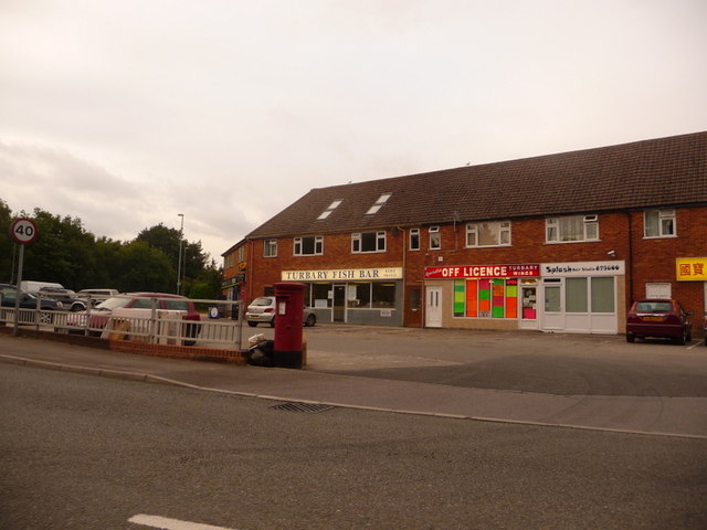
English: Ferndown: postbox № BH22 96, Turbary Road Turbary Road is the access road for a large housing estate which comprises a mix of council housing and desirable bungalows. Here, by the junction with the main road, are shops including a general store (round to the left), fish & chip shop, off licence and (out of picture, right) Chinese takeaway. The postbox, like the three in the estate, is emptied finally at 5:15pm on weekdays and at 12:30pm on Saturdays.
For many years residents of the estate campaigned for a post office, since it's quite a distance into Ferndown town from here but they never got one. |
| Dyddiad | |
| Ffynhonnell | From geograph.org.uk |
| Awdur | Chris Downer |
| Cydnabyddiaeth (required by the license) | Chris Downer / Ferndown: postbox № BH22 96, Turbary Road / |
| Camera location | | View this and other nearby images on: OpenStreetMap |
|---|
_heading:67.00&language=cy)
| Object location | | View this and other nearby images on: OpenStreetMap |
|---|
_heading:67.00&language=cy)
Trwyddedu

|
This image was taken from the Geograph project collection. See this photograph's page on the Geograph website for the photographer's contact details. The copyright on this image is owned by Chris Downer and is licensed for reuse under the Creative Commons Attribution-ShareAlike 2.0 license.
|
Trwyddedir y ffeil hon yn ôl termau'r drwydded Creative Commons Attribution-Share Alike 2.0 Generic.
Cydnabyddiaeth: Chris Downer
- Mae'n rhydd i chi:
- rhannu – gallwch gopïo, dosbarthu a throsglwyddo'r gwaith
- ailwampio – gallwch addasu'r gwaith
- Ar yr amodau canlynol:
- cydnabyddiaeth – Mae'n rhaid i chi nodi manylion y gwaith hwn, rhoi dolen i'r drwydded, a nodi os y bu golygu arni, yn y modd a benwyd gan yr awdur neu'r trwyddedwr (ond heb awgrymu o gwbl eu bod yn eich cymeradwyo chi na'ch defnydd o'r gwaith).
- rhannu ar dermau tebyg – Os byddwch yn addasu'r gwaith hwn, neu yn ei drawsnewid, neu yn adeiladu arno, mae'n rhaid i chi ddosbarthu'r gwaith dan drwydded sy'n union yr un fath same a'r gwreiddiol.
Hanes y ffeil
Cliciwch ar ddyddiad / amser i weld y ffeil fel ag yr oedd bryd hynny.
| Dyddiad / Amser | Bawdlun | Hyd a lled | Defnyddiwr | Sylw | |
|---|---|---|---|---|---|
| cyfredol | 04:30, 28 Chwefror 2011 | | 640 × 480 (55 KB) | GeographBot | == {{int:filedesc}} == {{Information |description={{en|1=Ferndown: postbox № BH22 96, Turbary Road Turbary Road is the access road for a large housing estate which comprises a mix of council housing and desirable bungalows. Here, by the junction wit |
Cysylltiadau'r ffeil
Mae'r 1 tudalennau a ddefnyddir isod yn cysylltu i'r ddelwedd hon:
Defnydd cydwici y ffeil
Mae'r wicis eraill hyn yn defnyddio'r ffeil hon:
- Y defnydd ar en.wikipedia.org
- Y defnydd ar www.wikidata.org