
Delwedd:Expanded Jerusalem 1967.jpg

Maint llawn ((868 × 1,346 picsel, maint y ffeil: 256 KB, ffurf MIME: image/jpeg))
Crynodeb
| Disgrifiad |
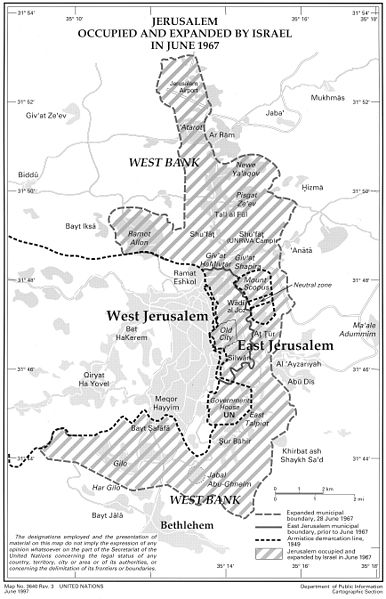
English: Expanded Jerusalem with municipal boundary of annexed East Jerusalem, imposed by Israel on 28 June 1967, following the occupation. UN Map No. 3640 Rev. 3, June 1997 |
| Dyddiad | |
| Ffynhonnell | http://unispal.un.org/UNISPAL.NSF/0/B2093AE6AC9DE94985256B98006E3AD2 |
| Awdur | United Nations |
Trwyddedu
| This image is a map derived from a United Nations map.
Unless stated otherwise, UN maps are to be considered in the public domain. This applies worldwide. UN maps are, in principle, open source material and you can use them in your work or for making your own map. UN requests however that you delete the UN name, logo and reference number upon any modification to the map. Content of your map will be your responsibility. You can state in your publication, if you wish, something like: based on UN map … (map name, map number, revision number and date). See: Geospatial Information Section. And: Geospatial, location data for a better world. |
 |
Hanes y ffeil
Cliciwch ar ddyddiad / amser i weld y ffeil fel ag yr oedd bryd hynny.
| Dyddiad / Amser | Bawdlun | Hyd a lled | Defnyddiwr | Sylw | |
|---|---|---|---|---|---|
| cyfredol | 10:29, 15 Mawrth 2014 | | 868 × 1,346 (256 KB) | Wickey-nl | User created page with UploadWizard |
Cysylltiadau'r ffeil
Mae'r 1 tudalennau a ddefnyddir isod yn cysylltu i'r ddelwedd hon:
Defnydd cydwici y ffeil
Mae'r wicis eraill hyn yn defnyddio'r ffeil hon:
- Y defnydd ar ca.wikipedia.org
- Y defnydd ar en.wikipedia.org
- Y defnydd ar ja.wikipedia.org
- Y defnydd ar nn.wikipedia.org
- Y defnydd ar no.wikipedia.org