
Delwedd:East Branch Clarion River Lake at Elk State Park.jpg
Maint y rhagolwg: 800 × 600 picsel. Eglurdebau eraill: 320 × 240 picsel | 640 × 480 picsel | 1,024 × 768 picsel | 1,280 × 960 picsel | 2,304 × 1,728 picsel.
Maint llawn ((2,304 × 1,728 picsel, maint y ffeil: 1.28 MB, ffurf MIME: image/jpeg))
Crynodeb
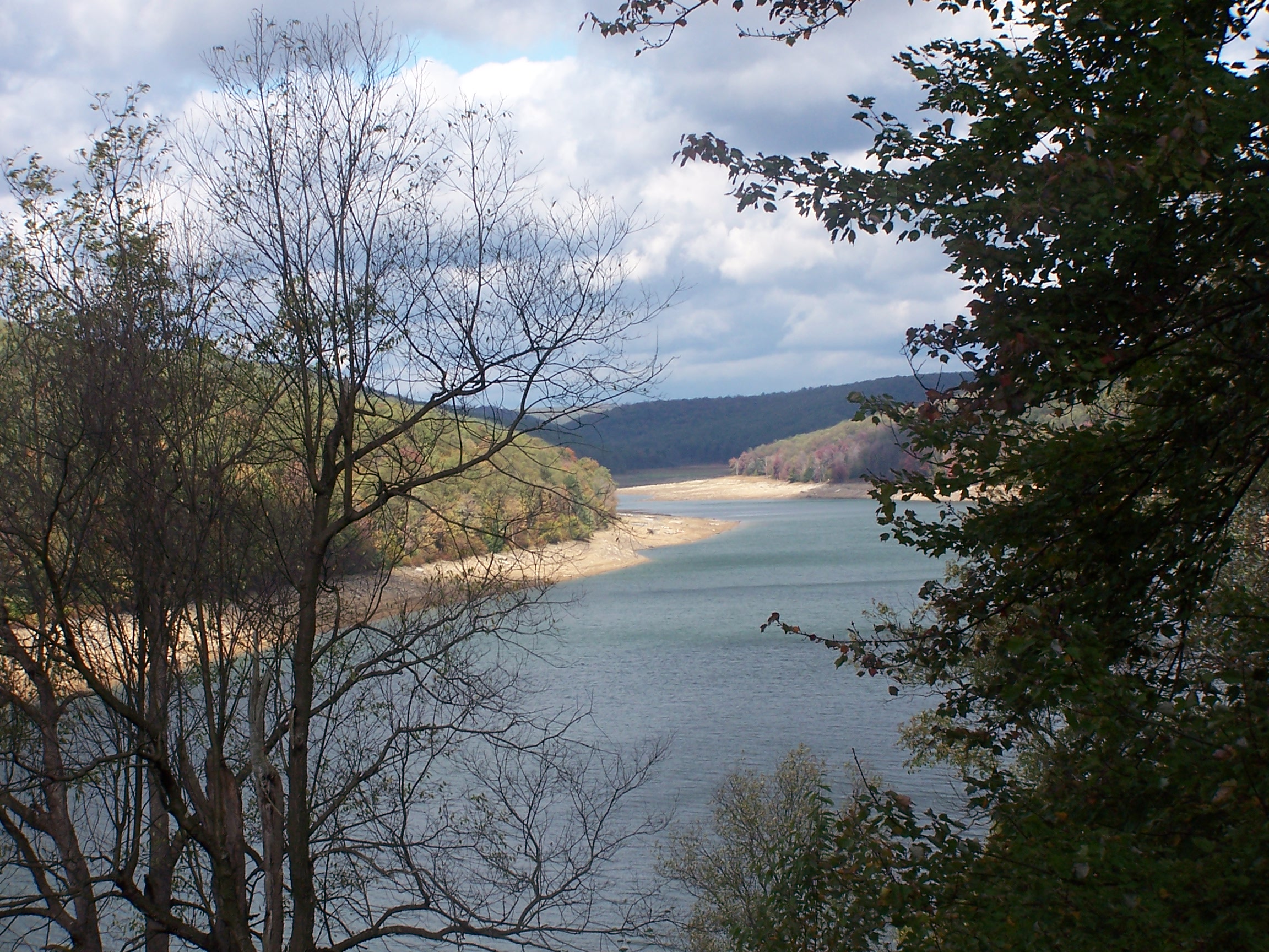
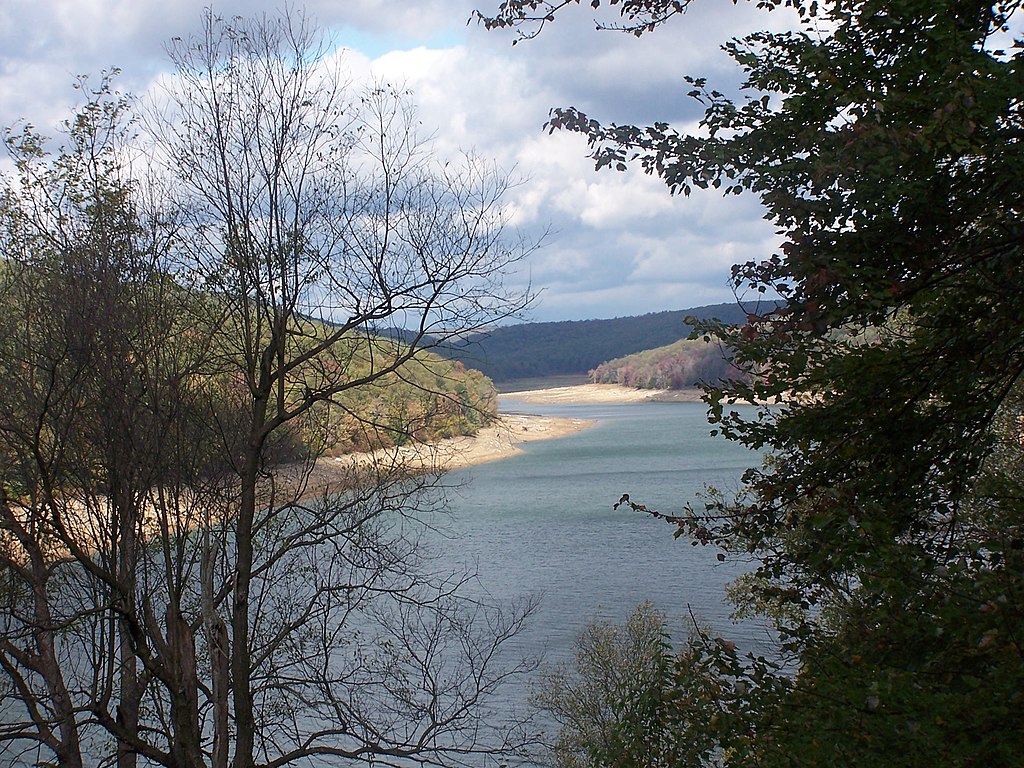
| Disgrifiad | The level of this reservoir varies widely in its function as a flood control for the Clarion & Allegheny Rivers. Under the water at just about the point it disappears around the bend is the town of Instanter. From the late 19th c until the 1920s, this area was nearly clearcut of hemlock - just to get the chemicals out of its bark. Location for this photo reached by driving twelve miles on unpaved roads and walking four miles more. Interestingly, when I located this on the Flickr map, it self identified as Instanter, which I did not know was still used as a geographical location. |
| Dyddiad | |
| Ffynhonnell | east branch reservoir elk county pa |
| Awdur | Tim Engleman |
Trwyddedu
Trwyddedir y ffeil hon yn ôl termau'r drwydded Creative Commons Attribution-Share Alike 2.0 Generic.
- Mae'n rhydd i chi:
- rhannu – gallwch gopïo, dosbarthu a throsglwyddo'r gwaith
- ailwampio – gallwch addasu'r gwaith
- Ar yr amodau canlynol:
- cydnabyddiaeth – Mae'n rhaid i chi nodi manylion y gwaith hwn, rhoi dolen i'r drwydded, a nodi os y bu golygu arni, yn y modd a benwyd gan yr awdur neu'r trwyddedwr (ond heb awgrymu o gwbl eu bod yn eich cymeradwyo chi na'ch defnydd o'r gwaith).
- rhannu ar dermau tebyg – Os byddwch yn addasu'r gwaith hwn, neu yn ei drawsnewid, neu yn adeiladu arno, mae'n rhaid i chi ddosbarthu'r gwaith dan drwydded sy'n union yr un fath same a'r gwreiddiol.
| This image was originally posted to Flickr by shadysidelantern at https://www.flickr.com/photos/92934406@N00/1591200427. It was reviewed on 30 Hydref 2007 by FlickreviewR and was confirmed to be licensed under the terms of the cc-by-sa-2.0. |
Hanes y ffeil
Cliciwch ar ddyddiad / amser i weld y ffeil fel ag yr oedd bryd hynny.
| Dyddiad / Amser | Bawdlun | Hyd a lled | Defnyddiwr | Sylw | |
|---|---|---|---|---|---|
| cyfredol | 03:23, 29 Mai 2012 | | 2,304 × 1,728 (1.28 MB) | Ruhrfisch | Original size version of current photo, all other information is the same |
| 22:03, 29 Hydref 2007 |  | 500 × 375 (185 KB) | Gerry D | {{Information |Description= The level of this reservoir varies widely in its function as a flood control for the Clarion & Allegheny Rivers. Under the water at just about the point it disappears around the bend is the town of Instanter. From the late 19 |
Cysylltiadau'r ffeil
Mae'r 1 tudalennau a ddefnyddir isod yn cysylltu i'r ddelwedd hon:
Defnydd cydwici y ffeil
Mae'r wicis eraill hyn yn defnyddio'r ffeil hon:
- Y defnydd ar ceb.wikipedia.org
- Y defnydd ar en.wikipedia.org
- Y defnydd ar es.wikipedia.org
- Y defnydd ar fr.wikipedia.org
- Y defnydd ar uk.wikipedia.org
- Y defnydd ar ur.wikipedia.org
- Y defnydd ar vi.wikipedia.org
- Y defnydd ar www.wikidata.org