
Delwedd:Derwent Water, Keswick - June 2009.jpg
Maint y rhagolwg: 800 × 209 picsel. Eglurdebau eraill: 320 × 84 picsel | 640 × 167 picsel | 1,024 × 268 picsel | 1,280 × 335 picsel | 7,649 × 2,000 picsel.
Maint llawn ((7,649 × 2,000 picsel, maint y ffeil: 5.02 MB, ffurf MIME: image/jpeg))
Crynodeb
| Disgrifiad |
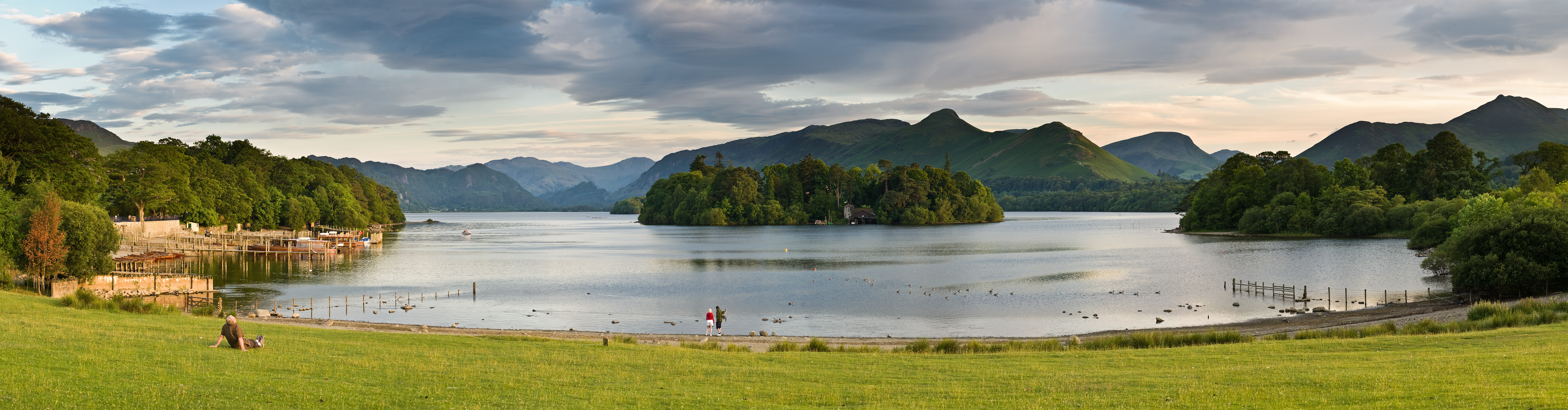
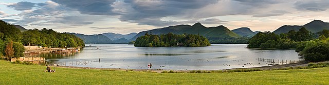
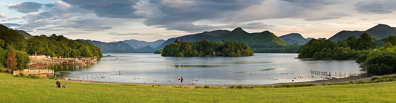
English: A wide 12 segment panoramic view of Derwent Water as viewed from the northern shore of Keswick. |
| Dyddiad | |
| Ffynhonnell | Gwaith yr uwchlwythwr |
| Awdur | Diliff |
| Caniatâd (Ailddefnyddio'r ffeil hon) |
Summary:In using this image or any subsequent derivatives of it, you are required to release the image under the same license. As such, any reproduction of this image, in any medium, must appear with a copy of, or full URL of the license.Attribution of this image to the author (DAVID ILIFF) is also required, preferably in a prominent location near the image.No other conditions may be added to, or removed from this license without the permission of the author and copyright holder.Suggested attribution: "Photo by DAVID ILIFF. License: CC BY-SA 3.0"Please review the full license requirements carefully before using this image. If you would like to clarify the terms of the license or negotiate less restrictive commercial licensing outside of the bounds of GFDL/CC-BY-SA, please contact me by email, or if you don't have a Wikipedia account you can either leave a message on my talk page with your contact details and your request, or you can contact me on Facebook. Please also send a 'friend request' to ensure that I am aware of your message. |
|
| Camera location | | View this and other nearby images on: OpenStreetMap |
|---|
Trwyddedu
Yr wyf fi, deiliad yr hawlfraint ar y gwaith hwn, yn ei gyhoeddi yn ôl termau'r trwyddedau a ganlyn:
Trwyddedir y ffeil hon yn ôl termau'r drwydded Creative Commons Attribution-Share Alike 3.0 Unported.
- Mae'n rhydd i chi:
- rhannu – gallwch gopïo, dosbarthu a throsglwyddo'r gwaith
- ailwampio – gallwch addasu'r gwaith
- Ar yr amodau canlynol:
- cydnabyddiaeth – Mae'n rhaid i chi nodi manylion y gwaith hwn, rhoi dolen i'r drwydded, a nodi os y bu golygu arni, yn y modd a benwyd gan yr awdur neu'r trwyddedwr (ond heb awgrymu o gwbl eu bod yn eich cymeradwyo chi na'ch defnydd o'r gwaith).
- rhannu ar dermau tebyg – Os byddwch yn addasu'r gwaith hwn, neu yn ei drawsnewid, neu yn adeiladu arno, mae'n rhaid i chi ddosbarthu'r gwaith dan drwydded sy'n union yr un fath same a'r gwreiddiol.

|
Caniateir copïo, dosbarthu a/neu golygu'r ddogfen hon yn ôl telerau'r Drwydded Ddogfennaeth Rydd GNU, Fersiwn 1.2 neu unrhyw fersiwn diweddarach a gyhoeddwyd gan y Free Software Foundation; yn cynnwys dim Adrannau Di-syfl, dim Testunau Clawr Blaen, a dim Testunau Clawr Cefn. Cynhwysir copi o'r drwydded hon yn yr adran Trwydded Ddogfennaeth Rydd GNU". |
Gallwch ddewis y drwydded y mynnwch.
Mae'r llun hwn wedi cael ei asesu yn ôl gofynion y Canllaw i Luniau Graenus ac yn cael ei gyfrif ymhlith y Lluniau Graenus.
|
Hanes y ffeil
Cliciwch ar ddyddiad / amser i weld y ffeil fel ag yr oedd bryd hynny.
| Dyddiad / Amser | Bawdlun | Hyd a lled | Defnyddiwr | Sylw | |
|---|---|---|---|---|---|
| cyfredol | 08:04, 2 Gorffennaf 2009 | 7,649 × 2,000 (5.02 MB) | Diliff | {{Information |Description={{en|1=A wide 12 segment panoramic view of Derwent Water as viewed from the northern shore of Keswick.}} |Source=Own work by uploader |Author=Diliff |Date=2009-06-25 |Permission={{Diliff/Licensing}} |other_versio |
Cysylltiadau'r ffeil
Mae'r 1 tudalennau a ddefnyddir isod yn cysylltu i'r ddelwedd hon:
Defnydd cydwici y ffeil
Mae'r wicis eraill hyn yn defnyddio'r ffeil hon:
- Y defnydd ar da.wikipedia.org
- Y defnydd ar de.wikipedia.org
- Y defnydd ar en.wikipedia.org
- Lake District
- Derwentwater
- User:Diliff
- Derwent Island House
- Talk:Derwentwater
- Wikipedia:Featured pictures/Places/Panorama
- Wikipedia:Featured pictures thumbs/19
- Wikipedia:Featured picture candidates/August-2009
- Wikipedia:Featured picture candidates/File:Derwent Water, Keswick - June 2009.jpg
- Wikipedia:Wikipedia Signpost/2009-08-24/Features and admins
- Portal:Cumbria/Selected picture
- Portal:Cumbria/Selected picture/1
- Wikipedia:Picture of the day/December 2010
- User talk:Diliff/Archive7
- Template:POTD/2010-12-07
- User talk:Diliff/Archive8
- User:Vietnamesepresident/Gallery
- Wikipedia:Wikipedia Signpost/2009-08-24/SPV
- Wikipedia:WikiProject Lakes/Recognized content
- Wikipedia:WikiProject England/Recognized content
- Wikipedia:Wikipedia Signpost/Single/2009-08-24
- Y defnydd ar fr.wikipedia.org
- Y defnydd ar hr.wikipedia.org
- Y defnydd ar it.wikipedia.org
- Y defnydd ar kw.wikipedia.org
- Y defnydd ar mt.wikipedia.org
- Y defnydd ar nl.wikipedia.org
- Y defnydd ar nn.wikipedia.org
- Y defnydd ar pa.wikipedia.org
- Y defnydd ar ru.wikipedia.org
- Y defnydd ar sl.wikipedia.org
- Y defnydd ar uk.wikipedia.org
- Y defnydd ar vi.wikipedia.org