
Delwedd:Coleford - geograph.org.uk - 1739525.jpg
Wedi ei chwyddo hyd yr eithaf.
Coleford_-_geograph.org.uk_-_1739525.jpg ((640 × 470 picsel, maint y ffeil: 70 KB, ffurf MIME: image/jpeg))
Crynodeb
| Disgrifiad |
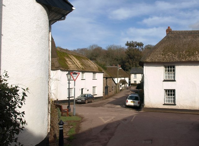
English: Coleford The crossroads in the centre of this pretty hamlet, consisting of many C17 cottages and other buildings; "Coleford is an unusually unspoilt and picturesque hamlet" https://historicengland.org.uk/listing/the-list/list-entry/1262078 . Across the road on the left is Browns Farm, formerly the Ship Inn https://historicengland.org.uk/listing/the-list/list-entry/1262078 . On the right is Corner Cottage https://historicengland.org.uk/listing/the-list/list-entry/1262039 . |
| Dyddiad | |
| Ffynhonnell | From geograph.org.uk |
| Awdur | Derek Harper |
| Cydnabyddiaeth (required by the license) | Derek Harper / Coleford / |
| Camera location | | View this and other nearby images on: OpenStreetMap |
|---|
_heading:45.00&language=cy)
| Object location | | View this and other nearby images on: OpenStreetMap |
|---|
_heading:45.00&language=cy)
Trwyddedu

|
This image was taken from the Geograph project collection. See this photograph's page on the Geograph website for the photographer's contact details. The copyright on this image is owned by Derek Harper and is licensed for reuse under the Creative Commons Attribution-ShareAlike 2.0 license.
|
Trwyddedir y ffeil hon yn ôl termau'r drwydded Creative Commons Attribution-Share Alike 2.0 Generic.
Cydnabyddiaeth: Derek Harper
- Mae'n rhydd i chi:
- rhannu – gallwch gopïo, dosbarthu a throsglwyddo'r gwaith
- ailwampio – gallwch addasu'r gwaith
- Ar yr amodau canlynol:
- cydnabyddiaeth – Mae'n rhaid i chi nodi manylion y gwaith hwn, rhoi dolen i'r drwydded, a nodi os y bu golygu arni, yn y modd a benwyd gan yr awdur neu'r trwyddedwr (ond heb awgrymu o gwbl eu bod yn eich cymeradwyo chi na'ch defnydd o'r gwaith).
- rhannu ar dermau tebyg – Os byddwch yn addasu'r gwaith hwn, neu yn ei drawsnewid, neu yn adeiladu arno, mae'n rhaid i chi ddosbarthu'r gwaith dan drwydded sy'n union yr un fath same a'r gwreiddiol.
Hanes y ffeil
Cliciwch ar ddyddiad / amser i weld y ffeil fel ag yr oedd bryd hynny.
| Dyddiad / Amser | Bawdlun | Hyd a lled | Defnyddiwr | Sylw | |
|---|---|---|---|---|---|
| cyfredol | 14:52, 5 Mawrth 2011 | | 640 × 470 (70 KB) | GeographBot | == {{int:filedesc}} == {{Information |description={{en|1=Coleford The crossroads in the centre of this pretty hamlet, consisting of many C17 cottages and other buildings; "Coleford is an unusually unspoilt and picturesque hamlet" http://www.imagesofenglan |
Cysylltiadau'r ffeil
Mae'r 1 tudalennau a ddefnyddir isod yn cysylltu i'r ddelwedd hon:
Defnydd cydwici y ffeil
Mae'r wicis eraill hyn yn defnyddio'r ffeil hon:
- Y defnydd ar en.wikipedia.org
- Y defnydd ar pl.wikipedia.org
- Y defnydd ar www.wikidata.org