
Delwedd:Centre of Fordingbridge - geograph.org.uk - 1525645.jpg
Wedi ei chwyddo hyd yr eithaf.
Centre_of_Fordingbridge_-_geograph.org.uk_-_1525645.jpg ((640 × 426 picsel, maint y ffeil: 203 KB, ffurf MIME: image/jpeg))
Crynodeb
| Disgrifiad |
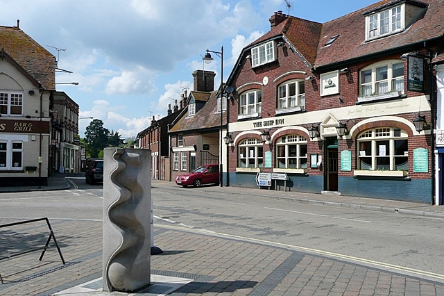
English: Centre of Fordingbridge This is the junction of Provost Street (left), Shaftesbury Street (ahead) and High Street (right) that can be regarded as the town centre. The Ship Inn probably indicates a time when the River Avon was navigable as far as the town, and the town name clearly indicates that this was the ford and later the bridge over the river. I would appreciate information about the sculpture in the foreground. The sculpture is by Paul Wilson of Salisbury. (http://wilsonsculpture.co.uk/gallery.htm) |
| Dyddiad | |
| Ffynhonnell | From geograph.org.uk |
| Awdur | Graham Horn |
| Cydnabyddiaeth (required by the license) | Graham Horn / Centre of Fordingbridge / |
| Camera location | | View this and other nearby images on: OpenStreetMap |
|---|
_heading:292.00&language=cy)
| Object location | | View this and other nearby images on: OpenStreetMap |
|---|
_heading:292.00&language=cy)
Trwyddedu

|
This image was taken from the Geograph project collection. See this photograph's page on the Geograph website for the photographer's contact details. The copyright on this image is owned by Graham Horn and is licensed for reuse under the Creative Commons Attribution-ShareAlike 2.0 license.
|
Trwyddedir y ffeil hon yn ôl termau'r drwydded Creative Commons Attribution-Share Alike 2.0 Generic.
Cydnabyddiaeth: Graham Horn
- Mae'n rhydd i chi:
- rhannu – gallwch gopïo, dosbarthu a throsglwyddo'r gwaith
- ailwampio – gallwch addasu'r gwaith
- Ar yr amodau canlynol:
- cydnabyddiaeth – Mae'n rhaid i chi nodi manylion y gwaith hwn, rhoi dolen i'r drwydded, a nodi os y bu golygu arni, yn y modd a benwyd gan yr awdur neu'r trwyddedwr (ond heb awgrymu o gwbl eu bod yn eich cymeradwyo chi na'ch defnydd o'r gwaith).
- rhannu ar dermau tebyg – Os byddwch yn addasu'r gwaith hwn, neu yn ei drawsnewid, neu yn adeiladu arno, mae'n rhaid i chi ddosbarthu'r gwaith dan drwydded sy'n union yr un fath same a'r gwreiddiol.
Hanes y ffeil
Cliciwch ar ddyddiad / amser i weld y ffeil fel ag yr oedd bryd hynny.
| Dyddiad / Amser | Bawdlun | Hyd a lled | Defnyddiwr | Sylw | |
|---|---|---|---|---|---|
| cyfredol | 02:51, 3 Mawrth 2011 | | 640 × 426 (203 KB) | GeographBot | == {{int:filedesc}} == {{Information |description={{en|1=Centre of Fordingbridge This is the junction of Provost Street (left), Shaftesbury Street (ahead) and High Street (right) that can be regarded as the town centre. The Ship Inn probably indicates a |
Cysylltiadau'r ffeil
Mae'r 1 tudalennau a ddefnyddir isod yn cysylltu i'r ddelwedd hon:
Defnydd cydwici y ffeil
Mae'r wicis eraill hyn yn defnyddio'r ffeil hon:
- Y defnydd ar azb.wikipedia.org
- Y defnydd ar ceb.wikipedia.org
- Y defnydd ar de.wikipedia.org
- Y defnydd ar en.wikivoyage.org
- Y defnydd ar es.wikipedia.org
- Y defnydd ar fa.wikipedia.org
- Y defnydd ar fr.wikipedia.org
- Y defnydd ar ga.wikipedia.org
- Y defnydd ar it.wikipedia.org
- Y defnydd ar lld.wikipedia.org
- Y defnydd ar nl.wikipedia.org
- Y defnydd ar ro.wikipedia.org
- Y defnydd ar sv.wikipedia.org
- Y defnydd ar www.wikidata.org