
Delwedd:Aerial view of an Oyster Reef (22819976251).jpg

Maint y rhagolwg: 800 × 533 picsel. Eglurdebau eraill: 320 × 213 picsel | 640 × 427 picsel | 1,024 × 683 picsel | 1,280 × 853 picsel | 2,560 × 1,707 picsel | 4,428 × 2,952 picsel.
Maint llawn ((4,428 × 2,952 picsel, maint y ffeil: 10.98 MB, ffurf MIME: image/jpeg))
.jpg)
Crynodeb
| Disgrifiad |
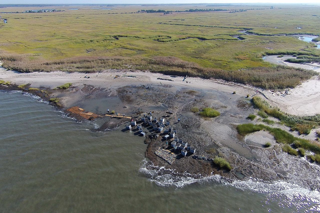
English: The first phase of the Hurricane Sandy-funded living shoreline installation in Downe Township, New Jersey, part of the Gandy’s Beach shoreline protection project, was completed in October 2015. For three days, partners and local volunteers placed a combination of “oyster castles” -- stackable, interlocking blocks of concrete, limestone, crushed shell and silica that encourage oyster larvae to settle -- and bagged oyster shells created by local schools, just offshore. Partner organizations will monitor the integrity of the structure through winter and apply findings to inform future reef installations in the same area next year. The work of this partnership will help stabilize approximately 3,000 feet of beach and tidal marsh shoreline, allowing the coast to heal itself.
|
| Dyddiad | |
| Ffynhonnell | https://www.flickr.com/photos/usfwsnortheast/22819976251/ |
| Awdur | U. S. Fish and Wildlife Service - Northeast Region |
| Caniatâd (Ailddefnyddio'r ffeil hon) |
At the time of upload, the image license was automatically confirmed using the Flickr API. For more information see Flickr API detail. |
| Flickr sets |
|
| Flickr tags |
|
| Camera location | | View this and other nearby images on: OpenStreetMap |
|---|
.jpg¶ms=039.278611_N_-075.243612_E_globe:Earth_type:camera__&language=cy)
Trwyddedu
Trwyddedir y ffeil hon yn ôl termau'r drwydded Creative Commons Attribution 2.0 Generic.
- Mae'n rhydd i chi:
- rhannu – gallwch gopïo, dosbarthu a throsglwyddo'r gwaith
- ailwampio – gallwch addasu'r gwaith
- Ar yr amodau canlynol:
- cydnabyddiaeth – Mae'n rhaid i chi nodi manylion y gwaith hwn, rhoi dolen i'r drwydded, a nodi os y bu golygu arni, yn y modd a benwyd gan yr awdur neu'r trwyddedwr (ond heb awgrymu o gwbl eu bod yn eich cymeradwyo chi na'ch defnydd o'r gwaith).
| This image was originally posted to Flickr by U. S. Fish and Wildlife Service - Northeast Region at https://flickr.com/photos/43322816@N08/22819976251. It was reviewed on 28 Medi 2016 by FlickreviewR and was confirmed to be licensed under the terms of the cc-by-2.0. |
This image or recording is the work of a U.S. Fish and Wildlife Service employee, taken or made as part of that person's official duties. As a work of the U.S. federal government, the image is in the public domain. For more information, see the Fish and Wildlife Service copyright policy.
|
 |
Hanes y ffeil
Cliciwch ar ddyddiad / amser i weld y ffeil fel ag yr oedd bryd hynny.
| Dyddiad / Amser | Bawdlun | Hyd a lled | Defnyddiwr | Sylw | |
|---|---|---|---|---|---|
| cyfredol | 13:22, 28 Medi 2016 | | 4,428 × 2,952 (10.98 MB) | Fæ | Flickr Set 72157644908524104, ID 22819976251, Original title Aerial view of an Oyster Reef |
Cysylltiadau'r ffeil
Mae'r 1 tudalennau a ddefnyddir isod yn cysylltu i'r ddelwedd hon:
Defnydd cydwici y ffeil
Mae'r wicis eraill hyn yn defnyddio'r ffeil hon:
- Y defnydd ar es.wikipedia.org
- Y defnydd ar ht.wikipedia.org
- Y defnydd ar uk.wikipedia.org
- Y defnydd ar www.wikidata.org
.jpg)