
Delwedd:Adpar and the county boundary - geograph.org.uk - 919887.jpg
Wedi ei chwyddo hyd yr eithaf.
Adpar_and_the_county_boundary_-_geograph.org.uk_-_919887.jpg ((640 × 480 picsel, maint y ffeil: 81 KB, ffurf MIME: image/jpeg))
Crynodeb
| Disgrifiad |
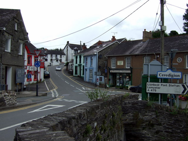
English: Adpar and the county boundary The river is the county boundary, Newcastle Emlyn to the south being in Sir Caerfyrddin and Adpar, seen here, in Sir Ceredigion.
This is an important river crossing where three roads converge: the A475 east from Llanbedr Pont Steffan and B roads from the north and west. Note the position of the letter box in the centre of the image, with a plaque beside it commemorating the site of Wales' first printing press. The house to the right of it was the Salutation Inn, scene of the quarrel that preceded the last duel fought in Wales, nearby, in 1814. See http://www.newcastleemlyn.info/page14.html |
| Dyddiad | |
| Ffynhonnell | From geograph.org.uk |
| Awdur | ceridwen |
| Cydnabyddiaeth (required by the license) | ceridwen / Adpar and the county boundary / |
| Camera location | | View this and other nearby images on: OpenStreetMap |
|---|
_heading:0.00&language=cy)
| Object location | | View this and other nearby images on: OpenStreetMap |
|---|
_heading:0.00&language=cy)
Trwyddedu

|
This image was taken from the Geograph project collection. See this photograph's page on the Geograph website for the photographer's contact details. The copyright on this image is owned by ceridwen and is licensed for reuse under the Creative Commons Attribution-ShareAlike 2.0 license.
|
Trwyddedir y ffeil hon yn ôl termau'r drwydded Creative Commons Attribution-Share Alike 2.0 Generic.
Cydnabyddiaeth: ceridwen
- Mae'n rhydd i chi:
- rhannu – gallwch gopïo, dosbarthu a throsglwyddo'r gwaith
- ailwampio – gallwch addasu'r gwaith
- Ar yr amodau canlynol:
- cydnabyddiaeth – Mae'n rhaid i chi nodi manylion y gwaith hwn, rhoi dolen i'r drwydded, a nodi os y bu golygu arni, yn y modd a benwyd gan yr awdur neu'r trwyddedwr (ond heb awgrymu o gwbl eu bod yn eich cymeradwyo chi na'ch defnydd o'r gwaith).
- rhannu ar dermau tebyg – Os byddwch yn addasu'r gwaith hwn, neu yn ei drawsnewid, neu yn adeiladu arno, mae'n rhaid i chi ddosbarthu'r gwaith dan drwydded sy'n union yr un fath same a'r gwreiddiol.
Hanes y ffeil
Cliciwch ar ddyddiad / amser i weld y ffeil fel ag yr oedd bryd hynny.
| Dyddiad / Amser | Bawdlun | Hyd a lled | Defnyddiwr | Sylw | |
|---|---|---|---|---|---|
| cyfredol | 22:11, 21 Chwefror 2011 | | 640 × 480 (81 KB) | GeographBot | == {{int:filedesc}} == {{Information |description={{en|1=Adpar and the county boundary The river is the county boundary, Newcastle Emlyn to the south being in Sir Caerfyrddin and Adpar, seen here, in Sir Ceredigion. This is an important river crossing wh |
Cysylltiadau'r ffeil
Mae'r 1 tudalennau a ddefnyddir isod yn cysylltu i'r ddelwedd hon:
Defnydd cydwici y ffeil
Mae'r wicis eraill hyn yn defnyddio'r ffeil hon: