
Delwedd:Ynys Gifftan - geograph.org.uk - 142069.jpg
Wedi ei chwyddo hyd yr eithaf.
Ynys_Gifftan_-_geograph.org.uk_-_142069.jpg ((640 × 480 picsel, maint y ffeil: 71 KB, ffurf MIME: image/jpeg))
Crynodeb
| Disgrifiad |
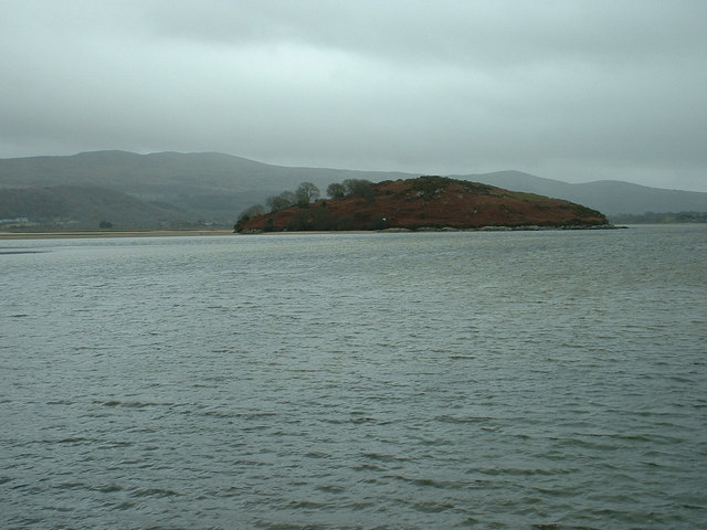
English: Ynys Gifftan. This is an island near the south east shore of Traeth Bach, the Dwyryd estuary. There is a public footpath to it across the estuary, but passable only at low tide - and even then, the water is usually at or above knee level. It's an exciting expedition to visit this now uninhabited island. There is a derelict farmhouse there, and some sheep grazing is still used. |
| Dyddiad | |
| Ffynhonnell | From geograph.org.uk |
| Awdur | David Medcalf |
| Cydnabyddiaeth (required by the license) | David Medcalf / Ynys Gifftan / |
| Camera location | | View this and other nearby images on: OpenStreetMap |
|---|
_&language=cy)
| Object location | | View this and other nearby images on: OpenStreetMap |
|---|
_&language=cy)
Trwyddedu

|
This image was taken from the Geograph project collection. See this photograph's page on the Geograph website for the photographer's contact details. The copyright on this image is owned by David Medcalf and is licensed for reuse under the Creative Commons Attribution-ShareAlike 2.0 license.
|
Trwyddedir y ffeil hon yn ôl termau'r drwydded Creative Commons Attribution-Share Alike 2.0 Generic.
Cydnabyddiaeth: David Medcalf
- Mae'n rhydd i chi:
- rhannu – gallwch gopïo, dosbarthu a throsglwyddo'r gwaith
- ailwampio – gallwch addasu'r gwaith
- Ar yr amodau canlynol:
- cydnabyddiaeth – Mae'n rhaid i chi nodi manylion y gwaith hwn, rhoi dolen i'r drwydded, a nodi os y bu golygu arni, yn y modd a benwyd gan yr awdur neu'r trwyddedwr (ond heb awgrymu o gwbl eu bod yn eich cymeradwyo chi na'ch defnydd o'r gwaith).
- rhannu ar dermau tebyg – Os byddwch yn addasu'r gwaith hwn, neu yn ei drawsnewid, neu yn adeiladu arno, mae'n rhaid i chi ddosbarthu'r gwaith dan drwydded sy'n union yr un fath same a'r gwreiddiol.
Hanes y ffeil
Cliciwch ar ddyddiad / amser i weld y ffeil fel ag yr oedd bryd hynny.
| Dyddiad / Amser | Bawdlun | Hyd a lled | Defnyddiwr | Sylw | |
|---|---|---|---|---|---|
| cyfredol | 11:12, 31 Ionawr 2010 | | 640 × 480 (71 KB) | GeographBot | == {{int:filedesc}} == {{Information |description={{en|1=Ynys Gifftan. This is an island near the south east shore of Traeth Bach, the Dwyryd estuary. There is a public footpath to it across the estuary, but passable only at low tide - and even then, the |
Cysylltiadau'r ffeil
Mae'r 1 tudalennau a ddefnyddir isod yn cysylltu i'r ddelwedd hon:
Defnydd cydwici y ffeil
Mae'r wicis eraill hyn yn defnyddio'r ffeil hon:
- Y defnydd ar en.wikipedia.org
- Y defnydd ar fr.wikipedia.org
- Y defnydd ar www.wikidata.org