
Delwedd:The Old Chapel, Creslow - geograph.org.uk - 234817.jpg
Wedi ei chwyddo hyd yr eithaf.
The_Old_Chapel,_Creslow_-_geograph.org.uk_-_234817.jpg ((640 × 480 picsel, maint y ffeil: 81 KB, ffurf MIME: image/jpeg))
Crynodeb
| Disgrifiad |
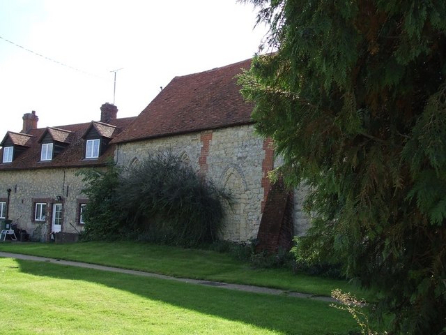
English: The Old Chapel, Creslow. This chapel is marked on the map and edged in black suggesting it is a public building, but it looks to me as though it has been incorporated into the adjoining building. The only signs were ones informing that there was no right of way for the public - so at best it probably has a very small congregation !
Edit: According to the English Heritage Viewfinder website "The former parish church, which ceased being used in the 18th century, was first a dovecot and is now used as an outbuilding of the Manor House. " ( See http://viewfinder.english-heritage.org.uk/search/reference.asp?index=385&imageUID=51561&main_query=&theme=&period=&county=&district=&place_name=Ham ) However the BHO website (see http://www.british-history.ac.uk/report.aspx?compid=42572&strquery=Parish%20Creslow#s3 ) itself quoting the "History of the County of Buckingham" suggests that it had not been used as a church since the time of Elizabeth I (1558-1603). A list of the rectors (see http://met.open.ac.uk/genuki/big/eng/BKM/Creslow/rectors.html ) finishes with the appointment of Thomas Davis A.M. in 1554 - which serves to confirm this earlier date.
|
|
| Dyddiad | ||
| Ffynhonnell | From geograph.org.uk | |
| Awdur | Rob Farrow | |
| Cydnabyddiaeth (required by the license) | Rob Farrow / The Old Chapel, Creslow / | |
| Object location | | View this and other nearby images on: OpenStreetMap |
|---|
_heading:135.00&language=cy)
Trwyddedu

|
This image was taken from the Geograph project collection. See this photograph's page on the Geograph website for the photographer's contact details. The copyright on this image is owned by Rob Farrow and is licensed for reuse under the Creative Commons Attribution-ShareAlike 2.0 license.
|
Trwyddedir y ffeil hon yn ôl termau'r drwydded Creative Commons Attribution-Share Alike 2.0 Generic.
Cydnabyddiaeth: Rob Farrow
- Mae'n rhydd i chi:
- rhannu – gallwch gopïo, dosbarthu a throsglwyddo'r gwaith
- ailwampio – gallwch addasu'r gwaith
- Ar yr amodau canlynol:
- cydnabyddiaeth – Mae'n rhaid i chi nodi manylion y gwaith hwn, rhoi dolen i'r drwydded, a nodi os y bu golygu arni, yn y modd a benwyd gan yr awdur neu'r trwyddedwr (ond heb awgrymu o gwbl eu bod yn eich cymeradwyo chi na'ch defnydd o'r gwaith).
- rhannu ar dermau tebyg – Os byddwch yn addasu'r gwaith hwn, neu yn ei drawsnewid, neu yn adeiladu arno, mae'n rhaid i chi ddosbarthu'r gwaith dan drwydded sy'n union yr un fath same a'r gwreiddiol.
Hanes y ffeil
Cliciwch ar ddyddiad / amser i weld y ffeil fel ag yr oedd bryd hynny.
| Dyddiad / Amser | Bawdlun | Hyd a lled | Defnyddiwr | Sylw | |
|---|---|---|---|---|---|
| cyfredol | 02:29, 1 Chwefror 2010 | | 640 × 480 (81 KB) | GeographBot | == {{int:filedesc}} == {{Information |description={{en|1=The Old Chapel, Creslow. This chapel is marked on the map and edged in black suggesting it is a public building, but it looks to me as though it has been incorporated into the adjoining building. Th |
Cysylltiadau'r ffeil
Mae'r 1 tudalennau a ddefnyddir isod yn cysylltu i'r ddelwedd hon:
Defnydd cydwici y ffeil
Mae'r wicis eraill hyn yn defnyddio'r ffeil hon:
- Y defnydd ar ar.wikipedia.org
- Y defnydd ar arz.wikipedia.org
- Y defnydd ar ceb.wikipedia.org
- Y defnydd ar en.wikipedia.org
- Y defnydd ar fr.wikipedia.org
- Y defnydd ar lld.wikipedia.org
- Y defnydd ar nl.wikipedia.org
- Y defnydd ar pl.wikipedia.org
- Y defnydd ar sv.wikipedia.org
- Y defnydd ar www.wikidata.org