
Delwedd:Temple Bruer Preceptory - geograph.org.uk - 1255134.jpg
Maint y rhagolwg: 399 × 599 picsel. Eglurdebau eraill: 160 × 240 picsel | 426 × 640 picsel.
Maint llawn ((426 × 640 picsel, maint y ffeil: 53 KB, ffurf MIME: image/jpeg))
Crynodeb
| Disgrifiad |
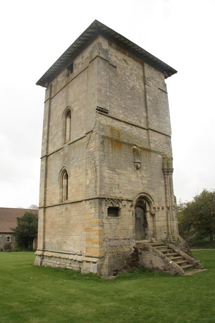
English: Temple Bruer Preceptory Grade I listed tower and Scheduled Ancient Monument at Temple Farm. All that remains of the Preceptory of the Knights Templar founded in 1185, this 13th century tower was one of a pair that stood east of the circular church. The Templars were suppressed in 1311 and the site became a Commandery for the Knights Hospitaller until its dissolution in 1538. |
| Dyddiad | |
| Ffynhonnell | From geograph.org.uk |
| Awdur | Richard Croft |
| Cydnabyddiaeth (required by the license) | Richard Croft / Temple Bruer Preceptory / |
| Camera location | | View this and other nearby images on: OpenStreetMap |
|---|
_heading:202.00&language=cy)
| Object location | | View this and other nearby images on: OpenStreetMap |
|---|
_heading:202.00&language=cy)
Trwyddedu

|
This image was taken from the Geograph project collection. See this photograph's page on the Geograph website for the photographer's contact details. The copyright on this image is owned by Richard Croft and is licensed for reuse under the Creative Commons Attribution-ShareAlike 2.0 license.
|
Trwyddedir y ffeil hon yn ôl termau'r drwydded Creative Commons Attribution-Share Alike 2.0 Generic.
Cydnabyddiaeth: Richard Croft
- Mae'n rhydd i chi:
- rhannu – gallwch gopïo, dosbarthu a throsglwyddo'r gwaith
- ailwampio – gallwch addasu'r gwaith
- Ar yr amodau canlynol:
- cydnabyddiaeth – Mae'n rhaid i chi nodi manylion y gwaith hwn, rhoi dolen i'r drwydded, a nodi os y bu golygu arni, yn y modd a benwyd gan yr awdur neu'r trwyddedwr (ond heb awgrymu o gwbl eu bod yn eich cymeradwyo chi na'ch defnydd o'r gwaith).
- rhannu ar dermau tebyg – Os byddwch yn addasu'r gwaith hwn, neu yn ei drawsnewid, neu yn adeiladu arno, mae'n rhaid i chi ddosbarthu'r gwaith dan drwydded sy'n union yr un fath same a'r gwreiddiol.
Hanes y ffeil
Cliciwch ar ddyddiad / amser i weld y ffeil fel ag yr oedd bryd hynny.
| Dyddiad / Amser | Bawdlun | Hyd a lled | Defnyddiwr | Sylw | |
|---|---|---|---|---|---|
| cyfredol | 21:18, 26 Chwefror 2011 | | 426 × 640 (53 KB) | GeographBot | == {{int:filedesc}} == {{Information |description={{en|1=Temple Bruer Preceptory Grade I listed tower and Scheduled Ancient Monument at Temple Farm. All that remains of the Preceptory of the Knights Templar founded in 1185, this 13th century tower was one |
Cysylltiadau'r ffeil
Mae'r 1 tudalennau a ddefnyddir isod yn cysylltu i'r ddelwedd hon:
Defnydd cydwici y ffeil
Mae'r wicis eraill hyn yn defnyddio'r ffeil hon:
- Y defnydd ar en.wikipedia.org
- Y defnydd ar fr.wikipedia.org
- Y defnydd ar it.wikipedia.org
- Y defnydd ar www.wikidata.org