
Delwedd:St Helen, Mareham-le-Fen - geograph.org.uk - 105510.jpg
Wedi ei chwyddo hyd yr eithaf.
St_Helen,_Mareham-le-Fen_-_geograph.org.uk_-_105510.jpg ((640 × 480 picsel, maint y ffeil: 99 KB, ffurf MIME: image/jpeg))
Crynodeb
| Disgrifiad |
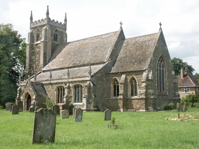
English: St Helen, Mareham-le-Fen. The earliest parts of the church date from about 1270 and they are the lower part of the tower and the tower arch. The church was largely restored in the 1870s, when the 14th-century chancel was almost entirely rebuilt. Further restoration work was done in the late 1960s and early 1970s. When the Mediaeval church of St Margaret, Old Woodhall was demolished, much of the material was brought over to build the new north vestry, kitchenette and vestibule. The font dates from the 14th-century, but the cover is modern. The registers were begun in 1558. The James Roberts gravestone, near the north door, was brought into the church to avoid further erosion. It commemorates the first voyage around the world under Captain James Cook. The famous botanist Joseph Banks from nearby Revesby was also aboard. |
| Dyddiad | |
| Ffynhonnell | From geograph.org.uk |
| Awdur | Dave Hitchborne |
| Cydnabyddiaeth (required by the license) | Dave Hitchborne / St Helen, Mareham-le-Fen / |
| Camera location | | View this and other nearby images on: OpenStreetMap |
|---|
_&language=cy)
| Object location | | View this and other nearby images on: OpenStreetMap |
|---|
_&language=cy)
Trwyddedu

|
This image was taken from the Geograph project collection. See this photograph's page on the Geograph website for the photographer's contact details. The copyright on this image is owned by Dave Hitchborne and is licensed for reuse under the Creative Commons Attribution-ShareAlike 2.0 license.
|
Trwyddedir y ffeil hon yn ôl termau'r drwydded Creative Commons Attribution-Share Alike 2.0 Generic.
Cydnabyddiaeth: Dave Hitchborne
- Mae'n rhydd i chi:
- rhannu – gallwch gopïo, dosbarthu a throsglwyddo'r gwaith
- ailwampio – gallwch addasu'r gwaith
- Ar yr amodau canlynol:
- cydnabyddiaeth – Mae'n rhaid i chi nodi manylion y gwaith hwn, rhoi dolen i'r drwydded, a nodi os y bu golygu arni, yn y modd a benwyd gan yr awdur neu'r trwyddedwr (ond heb awgrymu o gwbl eu bod yn eich cymeradwyo chi na'ch defnydd o'r gwaith).
- rhannu ar dermau tebyg – Os byddwch yn addasu'r gwaith hwn, neu yn ei drawsnewid, neu yn adeiladu arno, mae'n rhaid i chi ddosbarthu'r gwaith dan drwydded sy'n union yr un fath same a'r gwreiddiol.
Hanes y ffeil
Cliciwch ar ddyddiad / amser i weld y ffeil fel ag yr oedd bryd hynny.
| Dyddiad / Amser | Bawdlun | Hyd a lled | Defnyddiwr | Sylw | |
|---|---|---|---|---|---|
| cyfredol | 01:52, 31 Ionawr 2010 | | 640 × 480 (99 KB) | GeographBot | == {{int:filedesc}} == {{Information |description={{en|1=St Helen, Mareham-le-Fen. The earliest parts of the church date from about 1270 and they are the lower part of the tower and the tower arch. The church was largely restored in the 1870s, when the 14 |
Cysylltiadau'r ffeil
Mae'r 1 tudalennau a ddefnyddir isod yn cysylltu i'r ddelwedd hon:
Defnydd cydwici y ffeil
Mae'r wicis eraill hyn yn defnyddio'r ffeil hon:
- Y defnydd ar ceb.wikipedia.org
- Y defnydd ar de.wikipedia.org
- Y defnydd ar en.wikipedia.org
- Y defnydd ar es.wikipedia.org
- Y defnydd ar fa.wikipedia.org
- Y defnydd ar fr.wikipedia.org
- Y defnydd ar it.wikipedia.org
- Y defnydd ar lld.wikipedia.org
- Y defnydd ar pl.wikipedia.org
- Y defnydd ar www.wikidata.org