
Delwedd:St.Crallo's Church Coychurch - geograph.org.uk - 337153.jpg
Wedi ei chwyddo hyd yr eithaf.
St.Crallo's_Church_Coychurch_-_geograph.org.uk_-_337153.jpg ((640 × 379 picsel, maint y ffeil: 113 KB, ffurf MIME: image/jpeg))
|
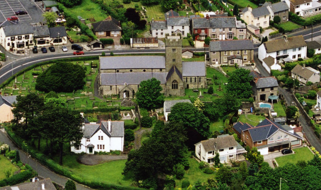
Dyma lun o adeilad rhestredig rhif 11252. |
Crynodeb
| Disgrifiad |
English: St.Crallo's Church Coychurch The Welsh name for the Village of Coychurch is Llangrallo. Obviously, named after St.Crallo. The white house, bottom left is the Rectory now used as the Llandaff Diocesan Office. The two houses, bottom right, are built on the site of a 7th Century Collegiate. The Church is of the 12th Century. |
| Dyddiad | |
| Ffynhonnell | From geograph.org.uk |
| Awdur | kenneth rees |
| Cydnabyddiaeth (required by the license) | kenneth rees / St.Crallo's Church Coychurch / |
| Camera location | | View this and other nearby images on: OpenStreetMap |
|---|
_heading:337.00&language=cy)
| Object location | | View this and other nearby images on: OpenStreetMap |
|---|
_heading:337.00&language=cy)
Trwyddedu

|
This image was taken from the Geograph project collection. See this photograph's page on the Geograph website for the photographer's contact details. The copyright on this image is owned by kenneth rees and is licensed for reuse under the Creative Commons Attribution-ShareAlike 2.0 license.
|
Trwyddedir y ffeil hon yn ôl termau'r drwydded Creative Commons Attribution-Share Alike 2.0 Generic.
Cydnabyddiaeth: kenneth rees
- Mae'n rhydd i chi:
- rhannu – gallwch gopïo, dosbarthu a throsglwyddo'r gwaith
- ailwampio – gallwch addasu'r gwaith
- Ar yr amodau canlynol:
- cydnabyddiaeth – Mae'n rhaid i chi nodi manylion y gwaith hwn, rhoi dolen i'r drwydded, a nodi os y bu golygu arni, yn y modd a benwyd gan yr awdur neu'r trwyddedwr (ond heb awgrymu o gwbl eu bod yn eich cymeradwyo chi na'ch defnydd o'r gwaith).
- rhannu ar dermau tebyg – Os byddwch yn addasu'r gwaith hwn, neu yn ei drawsnewid, neu yn adeiladu arno, mae'n rhaid i chi ddosbarthu'r gwaith dan drwydded sy'n union yr un fath same a'r gwreiddiol.
Hanes y ffeil
Cliciwch ar ddyddiad / amser i weld y ffeil fel ag yr oedd bryd hynny.
| Dyddiad / Amser | Bawdlun | Hyd a lled | Defnyddiwr | Sylw | |
|---|---|---|---|---|---|
| cyfredol | 22:30, 30 Rhagfyr 2010 | | 640 × 379 (113 KB) | GeographBot | == {{int:filedesc}} == {{Information |description={{en|1=St.Crallo's Church Coychurch The Welsh name for the Village of Coychurch is Llangrallo. Obviously, named after St.Crallo. The white house, bottom left is the Rectory now used as the Llandaff Diocesa |
Cysylltiadau'r ffeil
Mae'r 4 tudalennau a ddefnyddir isod yn cysylltu i'r ddelwedd hon:
Defnydd cydwici y ffeil
Mae'r wicis eraill hyn yn defnyddio'r ffeil hon:
- Y defnydd ar arz.wikipedia.org
- Y defnydd ar br.wikipedia.org
- Y defnydd ar ceb.wikipedia.org
- Y defnydd ar en.wikipedia.org
- Y defnydd ar eu.wikipedia.org
- Y defnydd ar fr.wikipedia.org
- Y defnydd ar it.wikipedia.org
- Y defnydd ar sv.wikipedia.org
- Y defnydd ar www.wikidata.org
- Y defnydd ar zh-min-nan.wikipedia.org