
Delwedd:Rhodes NLT Landsat7.png
Maint y rhagolwg: 605 × 600 picsel. Eglurdebau eraill: 242 × 240 picsel | 484 × 480 picsel | 775 × 768 picsel | 1,033 × 1,024 picsel | 1,948 × 1,931 picsel.
Maint llawn ((1,948 × 1,931 picsel, maint y ffeil: 5.65 MB, ffurf MIME: image/png))
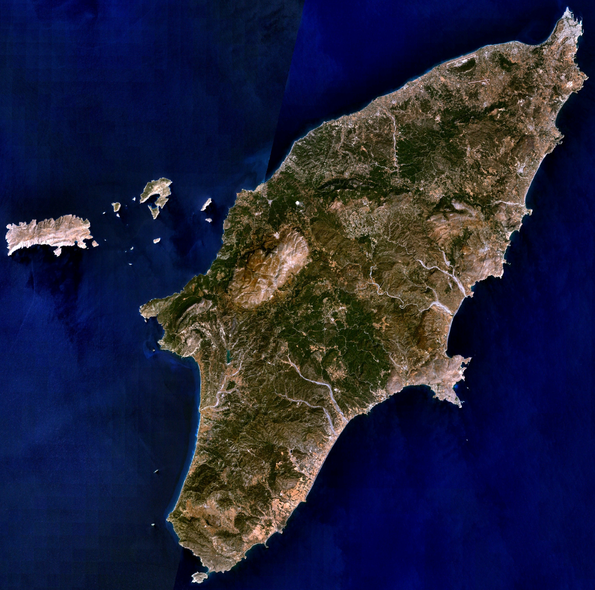
| Disgrifiad | Visible colour satellite image of Rhodes. | |||
| Ffynhonnell |
Screenshot from NASA World Wind, NLT Landsat7 layer. Coordinates: worldwind://goto/world=Earth&lat=36.16654&lon=27.93315&alt=80698 |
|||
| Awdur | Ffotograff: NASA | |||
| Caniatâd (Ailddefnyddio'r ffeil hon) |
|
|||
| Diwygiadau eraill | Image:Rodas.png |

Hanes y ffeil
Cliciwch ar ddyddiad / amser i weld y ffeil fel ag yr oedd bryd hynny.
| Dyddiad / Amser | Bawdlun | Hyd a lled | Defnyddiwr | Sylw | |
|---|---|---|---|---|---|
| cyfredol | 20:29, 16 Ebrill 2006 | | 1,948 × 1,931 (5.65 MB) | Hautala | {{Information| |Description=Visible colour satellite image of Rhodes. |Source=Screenshot from NASA World Wind, NLT Landsat7 layer. |Date= |Author= |Permission={{PD-WorldWind}} |other_versions= }} |
Cysylltiadau'r ffeil
Nid oes tudalennau'n defnyddio'r ffeil hon.
Defnydd cydwici y ffeil
Mae'r wicis eraill hyn yn defnyddio'r ffeil hon:
- Y defnydd ar ab.wikipedia.org
- Y defnydd ar als.wikipedia.org
- Y defnydd ar an.wikipedia.org
- Y defnydd ar ar.wikipedia.org
- Y defnydd ar az.wikipedia.org
- Y defnydd ar be-tarask.wikipedia.org
- Y defnydd ar be.wikipedia.org
- Y defnydd ar bg.wikipedia.org
- Y defnydd ar ca.wikipedia.org
- Y defnydd ar ceb.wikipedia.org
- Y defnydd ar cs.wikipedia.org
- Y defnydd ar da.wikipedia.org
- Y defnydd ar de.wikipedia.org
- Y defnydd ar el.wikipedia.org
- Y defnydd ar en.wikipedia.org
- Y defnydd ar eu.wikipedia.org
- Y defnydd ar fi.wikipedia.org
- Y defnydd ar fr.wikipedia.org
Gweld rhagor o'r defnydd cydwici o'r ffeil hon.