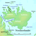
Delwedd:Nordaustlandet labelled.png

Ni chefnogir cynnwys y dudalen mewn ieithoedd eraill.
Oddi ar Wicipedia

Nordaustlandet_labelled.png((524 × 528 picsel, maint y ffeil: 119 KB, ffurf MIME: image/png))

Daw'r ffeil hon o Comin Wikimedia a gellir ei defnyddio gan brosiectau eraill. Dangosir isod y disgrifiad sydd ar dudalen ddisgrifio'r ffeil yno.

Crynodeb

Disgrifiad
English: Map detailing the marine features of Spitsbergen in the Svalbard archipelago. Settlements and mountains are indicated and labelled. See also Image:Spitsbergen mountains and marine features labelled.png. Locations were labelled mainly based on detailed maps from svalbard-images.com (sample of south Spitsbergen linked), cross-referenced with other map sources where possible. Norwegian Polar Institute figures were used for mountain names and heights, which are given in meters above sea level.
Dyddiad 29 Gorffennaf 2006 (original upload date)
Ffynhonnell No machine-readable source provided. Own work assumed (based on copyright claims).
Awdur No machine-readable author provided. TheGrappler assumed (based on copyright claims).

Trwyddedu

DEMIS World Map Server archive copy at the Wayback Machine generated this map from Public Domain sources. DEMIS does not claim any rights over the resultant image ([1] archive copy at the Wayback Machine). Alterations, including the addition of settlements and captions, were performed on 24 July 2006 by User:TheGrappler, the uploader, who releases all associated rights.

Public domain Yr wyf fi, deiliad hawlfraint y gwaith hwn, yn ei ryddhau i'r parth cyhoeddus, a hynny'n fyd-eang.
Hwyrach nad yw hyn yn bosib yn ôl cyfraith rhai gwledydd; os felly:
Rwyn rhoi i unrhywun yr hawl i ddefnyddio'r gwaith hwn at unrhyw ddiben, heb unrhyw amodau, oddieithr unrhyw amodau gofynnol yn ôl y gyfraith.
Public domain
This image is in the public domain because it came from the site https://www.demis.nl/products/web-map-server/examples/ and was released by the copyright holder. Permission is granted to copy, distribute and/or modify this map since it is based on free of copyright images from: www.demis.nl. See also approval email on de.wp and its clarification.

Deutsch | English | македонски | മലയാളം | Nederlands | slovenščina | +/−

Public domain This work has been released into the public domain by its copyright holder, www.demis.nl. This applies worldwide.
Hwyrach nad yw hyn yn bosib yn ôl cyfraith rhai gwledydd; os felly:
Mae www.demis.nl yn rhoi i unrhywun yr hawl i ddefnyddio'r gwaith hwn at unrhyw ddiben, heb unrhyw amodau, oddieithr unrhyw amodau gofynnol yn ôl y gyfraith.


derivative works

Derivative works of this file:  Wilhelmøya.PNG

Captions

Add a one-line explanation of what this file represents

Items portrayed in this file

yn portreadu

29 Gorffennaf 2006

Hanes y ffeil

Cliciwch ar ddyddiad / amser i weld y ffeil fel ag yr oedd bryd hynny.

Dyddiad / AmserBawdlunHyd a lledDefnyddiwrSylw
cyfredol02:47, 29 Gorffennaf 2006Bawdlun y fersiwn am 02:47, 29 Gorffennaf 2006524 × 528 (119 KB)TheGrapplerRemove cursor
01:08, 29 Gorffennaf 2006Bawdlun y fersiwn am 01:08, 29 Gorffennaf 2006524 × 528 (119 KB)TheGrapplerCorrect spelling
00:40, 29 Gorffennaf 2006Bawdlun y fersiwn am 00:40, 29 Gorffennaf 2006524 × 528 (119 KB)TheGrappler== Summary == {{English}} Map detailing the marine features of Spitsbergen in the Svalbard archipelago. Settlements and mountains are indicated and labelled. See also Image:Spitsbergen mountains and marine features labelled.png. Locations were labell

Mae'r 1 tudalennau a ddefnyddir isod yn cysylltu i'r ddelwedd hon:

Defnydd cydwici y ffeil