
Delwedd:Map of the Territory of the Parisii.svg

Maint rhagolwg PNG o ffeil SVG yw: 424 × 600 picsel. Eglurdebau eraill: 170 × 240 picsel | 339 × 480 picsel | 543 × 768 picsel | 724 × 1,024 picsel | 1,448 × 2,048 picsel | 744 × 1,052 picsel.
Maint llawn (Ffeil SVG, maint mewn enw 744 × 1,052 picsel, maint y ffeil: 148 KB)
| Disgrifiad |
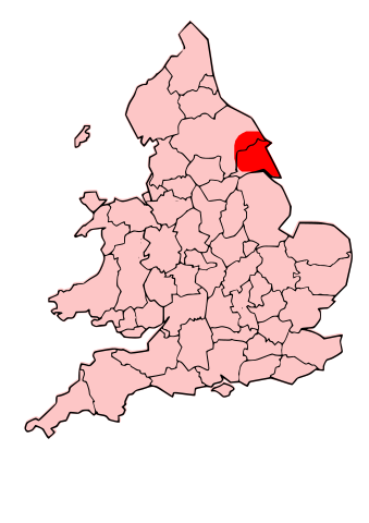
English: A map showing the territory of the Dobunni tribe overlayed in red in the context of the modern county boundaries of England and wales Image depicting the Celts of North and Midland England, pre-Roman Britain times. I created this myself, under the guidance (to find location of them) of Roman-Britain.org |
| Dyddiad | (UTC) |
| Ffynhonnell | |
| Awdur |
|
.svg)
.png)
| This is a retouched picture, which means that it has been digitally altered from its original version. Modifications: Modified county map with overlay of territory of parisii. The original can be viewed here: England Celtic tribes - North and Midlands.png:
|
Trwyddedir y ffeil hon yn ôl termau'r drwydded Creative Commons Attribution-Share Alike 3.0 Unported.
- Mae'n rhydd i chi:
- rhannu – gallwch gopïo, dosbarthu a throsglwyddo'r gwaith
- ailwampio – gallwch addasu'r gwaith
- Ar yr amodau canlynol:
- cydnabyddiaeth – Mae'n rhaid i chi nodi manylion y gwaith hwn, rhoi dolen i'r drwydded, a nodi os y bu golygu arni, yn y modd a benwyd gan yr awdur neu'r trwyddedwr (ond heb awgrymu o gwbl eu bod yn eich cymeradwyo chi na'ch defnydd o'r gwaith).
- rhannu ar dermau tebyg – Os byddwch yn addasu'r gwaith hwn, neu yn ei drawsnewid, neu yn adeiladu arno, mae'n rhaid i chi ddosbarthu'r gwaith dan drwydded sy'n union yr un fath same a'r gwreiddiol.
Cofnod lòg yr uwchlwythiad gwreiddiol
This image is a derivative work of the following images:
- File:Map_of_the_Territory_of_the_Dobunni.svg licensed with Cc-by-sa-3.0, GFDL
- 2009-10-13T19:47:34Z Jpb1301 744x1052 (151192 Bytes) {{Information |Description={{en|1=A map showing the territory of the Dobunni tribe overlayed in red in the context of the modern county boundaries of England and wales}} |Source=*[[:File:Map_of_the_Territory_of_the_Dobunni.sv
- 2009-10-13T17:38:36Z Jpb1301 744x1052 (151194 Bytes) {{Information |Description={{en|1=A map showing the territory of the Dobunni tribe overlayed in red in the context of the modern county boundaries of England and wales}} |Source=*[[:File:Map_of_the_Territory_of_the_Cornovii_(
- File:England_Celtic_tribes_-_North_and_Midlands.png licensed with Cc-by-sa-3.0
- 2009-07-29T23:43:34Z Thomas Gun 296x495 (27459 Bytes) == Summary == {{Information |Description=Image depicting the Celts of North and Midland England, pre-[[Roman Britain]] times. I created this myself, under the guidance (to find location of them) of [http://www.roman-britain.o
Uploaded with derivativeFX
Hanes y ffeil
Cliciwch ar ddyddiad / amser i weld y ffeil fel ag yr oedd bryd hynny.
| Dyddiad / Amser | Bawdlun | Hyd a lled | Defnyddiwr | Sylw | |
|---|---|---|---|---|---|
| cyfredol | 20:16, 16 Hydref 2009 | | 744 × 1,052 (148 KB) | Jpb1301 | {{Information |Description={{en|1=A map showing the territory of the Dobunni tribe overlayed in red in the context of the modern county boundaries of England and wales}}Image depicting the Celts of North and Midland England, pre-Roman Britain times. I |
Cysylltiadau'r ffeil
Mae'r 1 tudalennau a ddefnyddir isod yn cysylltu i'r ddelwedd hon:
Defnydd cydwici y ffeil
Mae'r wicis eraill hyn yn defnyddio'r ffeil hon:
- Y defnydd ar ca.wikipedia.org
- Y defnydd ar en.wikipedia.org
- Y defnydd ar fi.wikipedia.org
- Y defnydd ar fr.wikipedia.org
- Discussion:Parisii
- Parisii (Grande-Bretagne)
- Wikipédia:Statistiques des anecdotes de la page d'accueil/Visibilité des anecdotes (2020)
- Discussion:Parisii/LSV 17690
- Wikipédia:Statistiques des anecdotes de la page d'accueil/Visibilité des anecdotes (2020)/2020 02
- Projet:Aide et accueil/Twitter/Tweets/archives/février 2020
- Wikipédia:Le saviez-vous ?/Archives/2020
- Y defnydd ar la.wikipedia.org