
Delwedd:Map- France at the Treaty of Bretigny.jpg

Maint y rhagolwg: 478 × 600 picsel. Eglurdebau eraill: 191 × 240 picsel | 382 × 480 picsel | 612 × 768 picsel | 1,107 × 1,389 picsel.
Maint llawn ((1,107 × 1,389 picsel, maint y ffeil: 384 KB, ffurf MIME: image/jpeg))
Crynodeb
| Disgrifiad |
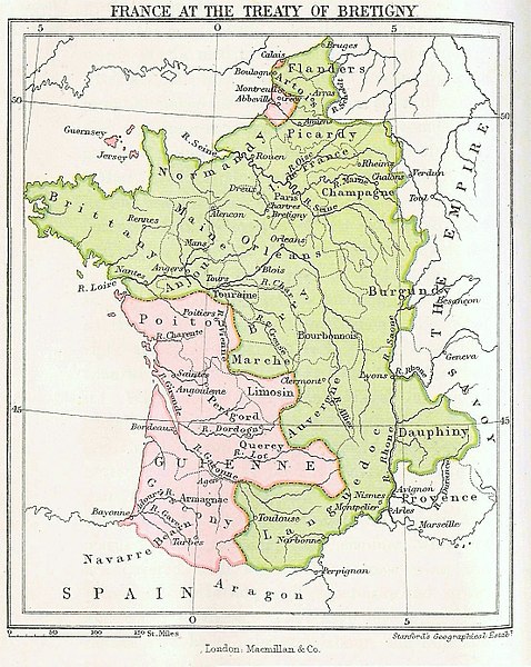
English: Map showing France at the time of the Treaty of Bretigny. |
| Dyddiad | (first publication date) |
| Ffynhonnell |
|
| Awdur | John Richard Green |
| Diwygiadau eraill |
.jpg)
Trwyddedu
This media file is in the public domain in the United States. This applies to U.S. works where the copyright has expired, often because its first publication occurred prior to January 1, 1929, and if not then due to lack of notice or renewal. See this page for further explanation.
|
 | |
 |
This image might not be in the public domain outside of the United States; this especially applies in the countries and areas that do not apply the rule of the shorter term for US works, such as Canada, Mainland China (not Hong Kong or Macao), Germany, Mexico, and Switzerland. The creator and year of publication are essential information and must be provided. See Wikipedia:Public domain and Wikipedia:Copyrights for more details.
|
|
This work is in the public domain in its country of origin and other countries and areas where the copyright term is the author's life plus 100 years or fewer. | |
| Canfyddwyd bod y ffeil yn rhydd o gyfyngiadau yn ôl cyfraith hawlfraint, gan gynnwys pob hawl perthynol a chyfagos. | |
Cofnod lòg yr uwchlwythiad gwreiddiol
The original description page was here. All following user names refer to en.wikipedia.
- 2006-09-09 16:14 Murraypaul 1107×1389× (359949 bytes) Map showing France at the time of the [[Treaty of Bretigny]]. Taken from ''History of the English People'', Volume 2 by [[John Richard Green]]. First published in 1877.
Hanes y ffeil
Cliciwch ar ddyddiad / amser i weld y ffeil fel ag yr oedd bryd hynny.
| Dyddiad / Amser | Bawdlun | Hyd a lled | Defnyddiwr | Sylw | |
|---|---|---|---|---|---|
| cyfredol | 16:03, 17 Mai 2017 | | 1,107 × 1,389 (384 KB) | Soerfm | Color |
| 11:35, 9 Mai 2011 |  | 1,107 × 1,389 (352 KB) | File Upload Bot (Magnus Manske) | {{BotMoveToCommons|en.wikipedia|year={{subst:CURRENTYEAR}}|month={{subst:CURRENTMONTHNAME}}|day={{subst:CURRENTDAY}}}} {{Information |Description={{en|Map showing France at the time of the en:Treaty of Bretigny. Taken from ''History of the English |
Cysylltiadau'r ffeil
Mae'r 1 tudalennau a ddefnyddir isod yn cysylltu i'r ddelwedd hon:
Defnydd cydwici y ffeil
Mae'r wicis eraill hyn yn defnyddio'r ffeil hon:
- Y defnydd ar az.wikipedia.org
- Y defnydd ar br.wikipedia.org
- Y defnydd ar ca.wikipedia.org
- Y defnydd ar cs.wikipedia.org
- Y defnydd ar da.wikipedia.org
- Y defnydd ar de.wikipedia.org
- Y defnydd ar el.wikipedia.org
- Y defnydd ar en.wikipedia.org
- Y defnydd ar es.wikipedia.org
- Y defnydd ar et.wikipedia.org
- Y defnydd ar eu.wikipedia.org
- Y defnydd ar fr.wikipedia.org
- Y defnydd ar fy.wikipedia.org
- Y defnydd ar hu.wikipedia.org
- Y defnydd ar hy.wikipedia.org
- Y defnydd ar ja.wikipedia.org
- Y defnydd ar ko.wikipedia.org
- Y defnydd ar nl.wikipedia.org
- Y defnydd ar pt.wikipedia.org
- Y defnydd ar ro.wikipedia.org
- Y defnydd ar ru.wikipedia.org
- Y defnydd ar sh.wikipedia.org
- Y defnydd ar sl.wikipedia.org
- Y defnydd ar sr.wikipedia.org
- Y defnydd ar sv.wikipedia.org
- Y defnydd ar uk.wikipedia.org
- Y defnydd ar vi.wikipedia.org
- Y defnydd ar www.wikidata.org
- Y defnydd ar zh.wikipedia.org