
Delwedd:Halter Devils Chapel - geograph.org.uk - 11358.jpg
Halter_Devils_Chapel_-_geograph.org.uk_-_11358.jpg ((640 × 427 picsel, maint y ffeil: 86 KB, ffurf MIME: image/jpeg))
Crynodeb
| Disgrifiad |
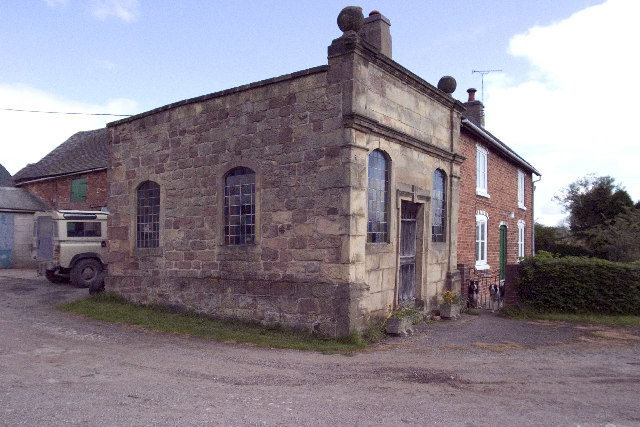
English: Halter Devils Chapel. Halter Devils Chapel, Between Mugginton and Mercaston, Derbyshire, SK267439
The Legend: One stormy night in 1723, a very drunken farmer called Francis Brown, decided to ride to Derby, about eight miles. He met his wife's protests with the remark 'Ride I will if I have to halter the devil'. As he was trying to put the halter on what he thought was a horse, a flash of lightning revealed that the animal had horns. He was so overcome by this that he remained sober for the rest of his life and built the chapel next to his house. In reality he had tried to halter one of his cows in his drunken state. A service is still held at this chapel on the last Sunday of the month, the farmer will give the key to see inside, (very nice) if you can find him and/or get past the noisy pack of dogs that roam around the farm! |
| Dyddiad | |
| Ffynhonnell | From geograph.org.uk |
| Awdur | Rob Bradford |
This is a photo of listed building number 1158486. |
This is a photo of listed building number 1109720. |
| Camera location | | View this and other nearby images on: OpenStreetMap |
|---|
_heading:22.00&language=cy)
| Object location | | View this and other nearby images on: OpenStreetMap |
|---|
_heading:22.00&language=cy)
Trwyddedu

|
This image was taken from the Geograph project collection. See this photograph's page on the Geograph website for the photographer's contact details. The copyright on this image is owned by Rob Bradford and is licensed for reuse under the Creative Commons Attribution-ShareAlike 2.0 license.
|
- Mae'n rhydd i chi:
- rhannu – gallwch gopïo, dosbarthu a throsglwyddo'r gwaith
- ailwampio – gallwch addasu'r gwaith
- Ar yr amodau canlynol:
- cydnabyddiaeth – Mae'n rhaid i chi nodi manylion y gwaith hwn, rhoi dolen i'r drwydded, a nodi os y bu golygu arni, yn y modd a benwyd gan yr awdur neu'r trwyddedwr (ond heb awgrymu o gwbl eu bod yn eich cymeradwyo chi na'ch defnydd o'r gwaith).
- rhannu ar dermau tebyg – Os byddwch yn addasu'r gwaith hwn, neu yn ei drawsnewid, neu yn adeiladu arno, mae'n rhaid i chi ddosbarthu'r gwaith dan drwydded sy'n union yr un fath same a'r gwreiddiol.
Hanes y ffeil
Cliciwch ar ddyddiad / amser i weld y ffeil fel ag yr oedd bryd hynny.
| Dyddiad / Amser | Bawdlun | Hyd a lled | Defnyddiwr | Sylw | |
|---|---|---|---|---|---|
| cyfredol | 03:09, 30 Ionawr 2010 | | 640 × 427 (86 KB) | GeographBot | == {{int:filedesc}} == {{Information |description={{en|1=Halter Devils Chapel. Halter Devils Chapel, Between Muggington and Mercaston, Derbyshire, SK267439 The Legend: One stormy night in 1723, a very drunken farmer called Francis Brown, decided to rid |
Cysylltiadau'r ffeil
Nid oes tudalennau'n defnyddio'r ffeil hon.
Defnydd cydwici y ffeil
Mae'r wicis eraill hyn yn defnyddio'r ffeil hon:
- Y defnydd ar en.wikipedia.org
- Y defnydd ar fa.wikipedia.org
- Y defnydd ar fr.wikipedia.org
- Y defnydd ar pl.wikipedia.org