
Delwedd:Cows on Selsley Common - geograph.org.uk - 192472.jpg
Wedi ei chwyddo hyd yr eithaf.
Cows_on_Selsley_Common_-_geograph.org.uk_-_192472.jpg ((640 × 480 picsel, maint y ffeil: 155 KB, ffurf MIME: image/jpeg))
Crynodeb
| Disgrifiad |
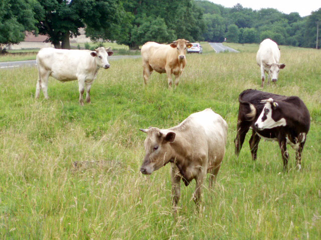
English: Cows on Selsley Common. With so much land to roam on, these cows have chosen to find pasture perilously close to the B4066. Cattle grids placed a strategic locations prevent the cattle from straying from the commonland.
Français : Vaches sur les prés communaux de Selsley. Bien que disposant d'un vaste espace à brouter, ces vaches ont choisir de pâturer à une dangereusement proximité de la B4066 (risque de roadkill). Des grillages à Bovins placés à des endroits stratégiques peuvent empêcher la divagation du bétail des "commons" |
| Dyddiad | |
| Ffynhonnell | From geograph.org.uk |
| Awdur | Sharon Loxton |
| Cydnabyddiaeth (required by the license) | Sharon Loxton / Cows on Selsley Common / |
| Camera location | | View this and other nearby images on: OpenStreetMap |
|---|
_heading:202.00&language=cy)
| Object location | | View this and other nearby images on: OpenStreetMap |
|---|
_heading:202.00&language=cy)
Trwyddedu

|
This image was taken from the Geograph project collection. See this photograph's page on the Geograph website for the photographer's contact details. The copyright on this image is owned by Sharon Loxton and is licensed for reuse under the Creative Commons Attribution-ShareAlike 2.0 license.
|
Trwyddedir y ffeil hon yn ôl termau'r drwydded Creative Commons Attribution-Share Alike 2.0 Generic.
Cydnabyddiaeth: Sharon Loxton
- Mae'n rhydd i chi:
- rhannu – gallwch gopïo, dosbarthu a throsglwyddo'r gwaith
- ailwampio – gallwch addasu'r gwaith
- Ar yr amodau canlynol:
- cydnabyddiaeth – Mae'n rhaid i chi nodi manylion y gwaith hwn, rhoi dolen i'r drwydded, a nodi os y bu golygu arni, yn y modd a benwyd gan yr awdur neu'r trwyddedwr (ond heb awgrymu o gwbl eu bod yn eich cymeradwyo chi na'ch defnydd o'r gwaith).
- rhannu ar dermau tebyg – Os byddwch yn addasu'r gwaith hwn, neu yn ei drawsnewid, neu yn adeiladu arno, mae'n rhaid i chi ddosbarthu'r gwaith dan drwydded sy'n union yr un fath same a'r gwreiddiol.
- Remove redundant categories and try to put this image in the most specific category/categories
- Remove this template
- The location categories are based on information from this geonames tool and this OpenStreetMap tool combined with a database. You can also have a look at this tool from mysociety.
- The topic category from Geograph was Common (find similar images at Geograph)
Hanes y ffeil
Cliciwch ar ddyddiad / amser i weld y ffeil fel ag yr oedd bryd hynny.
| Dyddiad / Amser | Bawdlun | Hyd a lled | Defnyddiwr | Sylw | |
|---|---|---|---|---|---|
| cyfredol | 15:37, 31 Ionawr 2010 | | 640 × 480 (155 KB) | GeographBot | == {{int:filedesc}} == {{Information |description={{en|1=Cows on Selsley Common. With so much land to roam on, these cows have chosen to find pasture perilously close to the B4066. Cattle grids placed a strategic locations prevent the cattle from strayin |
Cysylltiadau'r ffeil
Mae'r 1 tudalennau a ddefnyddir isod yn cysylltu i'r ddelwedd hon:
Defnydd cydwici y ffeil
Mae'r wicis eraill hyn yn defnyddio'r ffeil hon:
- Y defnydd ar ar.wikipedia.org
- Y defnydd ar en.wikipedia.org
- Y defnydd ar eu.wikipedia.org
- Y defnydd ar fr.wikipedia.org
- Y defnydd ar gl.wikipedia.org
- Y defnydd ar ha.wikipedia.org
- Y defnydd ar ko.wikipedia.org
- Y defnydd ar mg.wikipedia.org
- Y defnydd ar nn.wikipedia.org
- Y defnydd ar pl.wikipedia.org
- Y defnydd ar tr.wikipedia.org
- Y defnydd ar www.wikidata.org
- Y defnydd ar zh-yue.wikipedia.org
- Y defnydd ar zh.wikipedia.org