
Delwedd:Church spires in Galashiels - geograph.org.uk - 717309.jpg
Wedi ei chwyddo hyd yr eithaf.
Church_spires_in_Galashiels_-_geograph.org.uk_-_717309.jpg ((637 × 415 picsel, maint y ffeil: 115 KB, ffurf MIME: image/jpeg))
Crynodeb
| Disgrifiad |
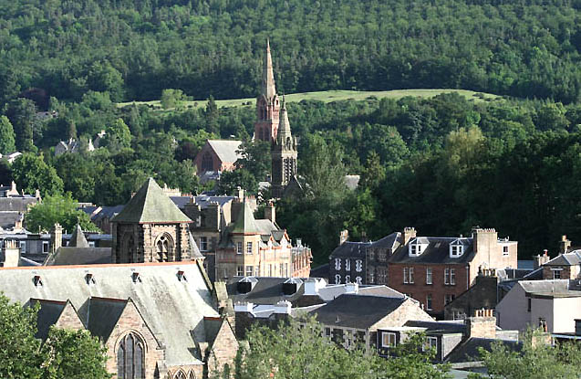
English: Church spires in Galashiels Viewed from the High Road, this shows in the left foreground, St Andrew's Arts Centre in Bridge Street which was built as St Andrew's Church in 1885. The spire in the centre is at St Aidan's Church in Gala Park, opened in 1880 but closed in 2005. The red sandstone spire behind St Aidan's Church is at Old Parish and St Paul's Church in Scott Crescent which opened in 1881. The 58m spire was finished in 1885 and for the past few years a pair of peregrine falcons have nested here and successfully reared young. The former spire of St Andrew's Church was reduced to a small pyramidal roof, a poor substitute for what was a great spire, and a major loss to the roofscape of the town. |
| Dyddiad | |
| Ffynhonnell | From geograph.org.uk |
| Awdur | Walter Baxter |
| Cydnabyddiaeth (required by the license) | Walter Baxter / Church spires in Galashiels / |
| Camera location | | View this and other nearby images on: OpenStreetMap |
|---|
_heading:180.00&language=cy)
| Object location | | View this and other nearby images on: OpenStreetMap |
|---|
_heading:180.00&language=cy)
Trwyddedu

|
This image was taken from the Geograph project collection. See this photograph's page on the Geograph website for the photographer's contact details. The copyright on this image is owned by Walter Baxter and is licensed for reuse under the Creative Commons Attribution-ShareAlike 2.0 license.
|
Trwyddedir y ffeil hon yn ôl termau'r drwydded Creative Commons Attribution-Share Alike 2.0 Generic.
Cydnabyddiaeth: Walter Baxter
- Mae'n rhydd i chi:
- rhannu – gallwch gopïo, dosbarthu a throsglwyddo'r gwaith
- ailwampio – gallwch addasu'r gwaith
- Ar yr amodau canlynol:
- cydnabyddiaeth – Mae'n rhaid i chi nodi manylion y gwaith hwn, rhoi dolen i'r drwydded, a nodi os y bu golygu arni, yn y modd a benwyd gan yr awdur neu'r trwyddedwr (ond heb awgrymu o gwbl eu bod yn eich cymeradwyo chi na'ch defnydd o'r gwaith).
- rhannu ar dermau tebyg – Os byddwch yn addasu'r gwaith hwn, neu yn ei drawsnewid, neu yn adeiladu arno, mae'n rhaid i chi ddosbarthu'r gwaith dan drwydded sy'n union yr un fath same a'r gwreiddiol.
Hanes y ffeil
Cliciwch ar ddyddiad / amser i weld y ffeil fel ag yr oedd bryd hynny.
| Dyddiad / Amser | Bawdlun | Hyd a lled | Defnyddiwr | Sylw | |
|---|---|---|---|---|---|
| cyfredol | 00:58, 19 Chwefror 2011 | | 637 × 415 (115 KB) | GeographBot | == {{int:filedesc}} == {{Information |description={{en|1=Church spires in Galashiels Viewed from the High Road, this shows in the left foreground, St Andrew's Arts Centre in Bridge Street which was built as St Andrew's Church in 1885. The spire in the cen |
Cysylltiadau'r ffeil
Mae'r 1 tudalennau a ddefnyddir isod yn cysylltu i'r ddelwedd hon:
Defnydd cydwici y ffeil
Mae'r wicis eraill hyn yn defnyddio'r ffeil hon:
- Y defnydd ar ceb.wikipedia.org
- Y defnydd ar de.wikivoyage.org
- Y defnydd ar en.wikipedia.org
- Y defnydd ar en.wikivoyage.org
- Y defnydd ar es.wikipedia.org
- Y defnydd ar eu.wikipedia.org
- Y defnydd ar fa.wikipedia.org
- Y defnydd ar fr.wikipedia.org
- Y defnydd ar ga.wikipedia.org
- Y defnydd ar nl.wikipedia.org
- Y defnydd ar nn.wikipedia.org
- Y defnydd ar no.wikipedia.org
- Y defnydd ar pl.wikipedia.org
- Y defnydd ar ru.wikipedia.org
- Y defnydd ar ur.wikipedia.org
- Y defnydd ar www.wikidata.org