
Delwedd:All Saints church, Graveney - geograph.org.uk - 145368.jpg
Wedi ei chwyddo hyd yr eithaf.
All_Saints_church,_Graveney_-_geograph.org.uk_-_145368.jpg ((640 × 480 picsel, maint y ffeil: 125 KB, ffurf MIME: image/jpeg))
Crynodeb
| Disgrifiad |
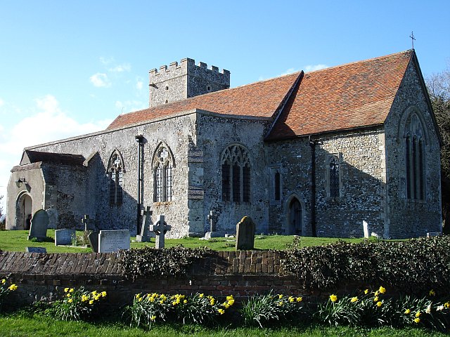
English: All Saints church, Graveney. The church stands next to a large farm and its associated cottages, the rest of this small community, including the primary school is about 200 metres down the road to the south. The whole community is surrounded by marsh, no longer tidal since the sea wall was built in 1325. The church stands about 12 metres above sea level and the land rises to the south and west. |
| Dyddiad | |
| Ffynhonnell | From geograph.org.uk |
| Awdur | Penny Mayes |
| Cydnabyddiaeth (required by the license) | Penny Mayes / All Saints church, Graveney / |
| Camera location | | View this and other nearby images on: OpenStreetMap |
|---|
_heading:315.00&language=cy)
| Object location | | View this and other nearby images on: OpenStreetMap |
|---|
_heading:315.00&language=cy)
Trwyddedu

|
This image was taken from the Geograph project collection. See this photograph's page on the Geograph website for the photographer's contact details. The copyright on this image is owned by Penny Mayes and is licensed for reuse under the Creative Commons Attribution-ShareAlike 2.0 license.
|
Trwyddedir y ffeil hon yn ôl termau'r drwydded Creative Commons Attribution-Share Alike 2.0 Generic.
Cydnabyddiaeth: Penny Mayes
- Mae'n rhydd i chi:
- rhannu – gallwch gopïo, dosbarthu a throsglwyddo'r gwaith
- ailwampio – gallwch addasu'r gwaith
- Ar yr amodau canlynol:
- cydnabyddiaeth – Mae'n rhaid i chi nodi manylion y gwaith hwn, rhoi dolen i'r drwydded, a nodi os y bu golygu arni, yn y modd a benwyd gan yr awdur neu'r trwyddedwr (ond heb awgrymu o gwbl eu bod yn eich cymeradwyo chi na'ch defnydd o'r gwaith).
- rhannu ar dermau tebyg – Os byddwch yn addasu'r gwaith hwn, neu yn ei drawsnewid, neu yn adeiladu arno, mae'n rhaid i chi ddosbarthu'r gwaith dan drwydded sy'n union yr un fath same a'r gwreiddiol.
Hanes y ffeil
Cliciwch ar ddyddiad / amser i weld y ffeil fel ag yr oedd bryd hynny.
| Dyddiad / Amser | Bawdlun | Hyd a lled | Defnyddiwr | Sylw | |
|---|---|---|---|---|---|
| cyfredol | 05:09, 31 Ionawr 2010 | | 640 × 480 (125 KB) | GeographBot | == {{int:filedesc}} == {{Information |description={{en|1=All Saints church, Graveney. The church stands next to a large farm and its associated cottages, the rest of this small community, including the primary school is about 200 metres down the road to t |
Cysylltiadau'r ffeil
Mae'r 1 tudalennau a ddefnyddir isod yn cysylltu i'r ddelwedd hon:
Defnydd cydwici y ffeil
Mae'r wicis eraill hyn yn defnyddio'r ffeil hon:
- Y defnydd ar de.wikipedia.org
- Y defnydd ar en.wikipedia.org
- Y defnydd ar lld.wikipedia.org
- Y defnydd ar pl.wikipedia.org
- Y defnydd ar sv.wikipedia.org
- Y defnydd ar www.wikidata.org