
Delwedd:1500 map by Juan de la Cosa.jpg
Maint y rhagolwg: 328 × 600 picsel. Eglurdebau eraill: 131 × 240 picsel | 262 × 480 picsel | 420 × 768 picsel | 1,163 × 2,127 picsel.
Maint llawn ((1,163 × 2,127 picsel, maint y ffeil: 3.33 MB, ffurf MIME: image/jpeg))
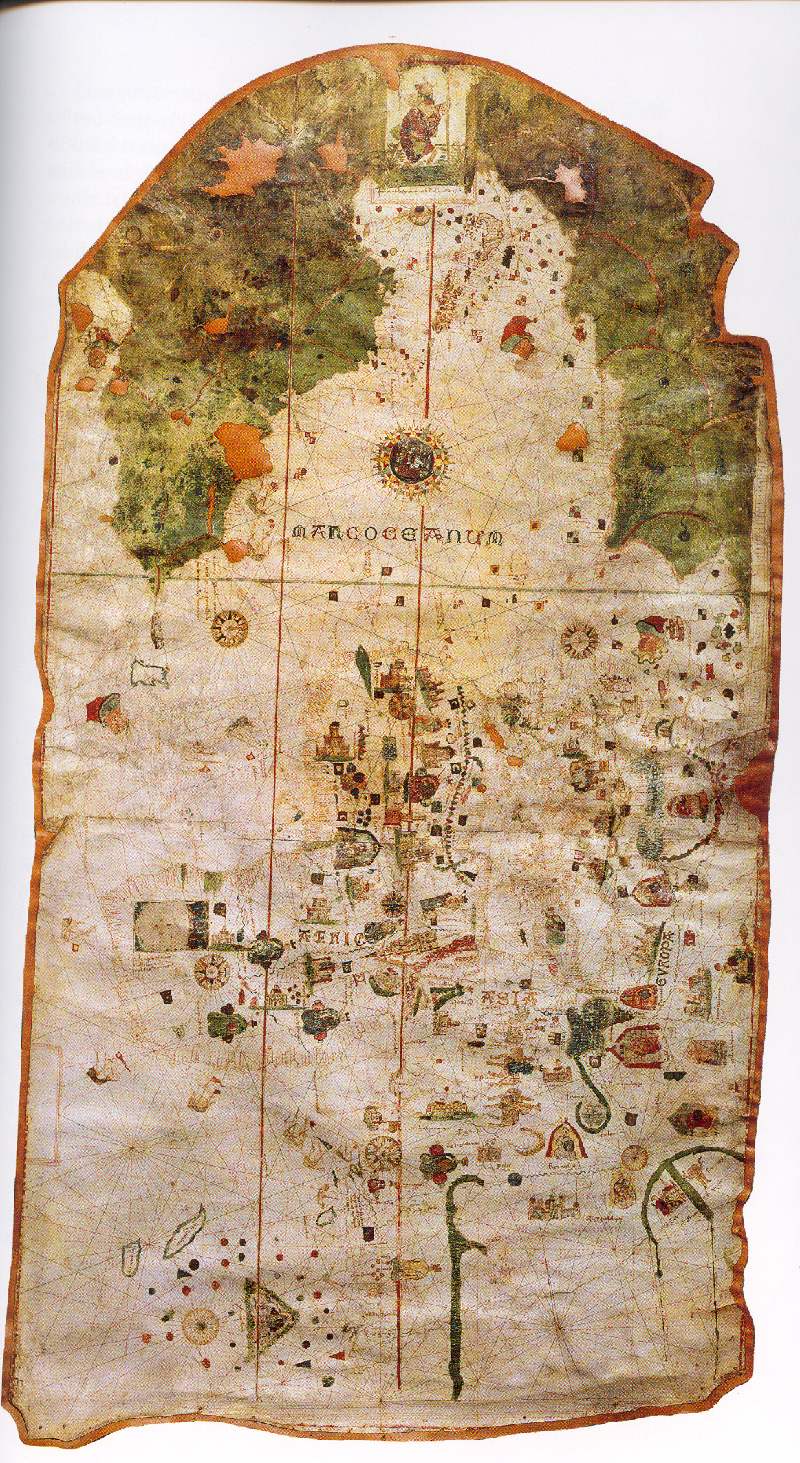
| Juan de la Cosa: English: Called Map of Juan de la Cosa.
Español: Llamado Mapa de Juan de la Cosa. Esperanto: La tiel nomita Mapo de Juan de la Cosa. ( |
|||||||||||||||||||||||||||
|---|---|---|---|---|---|---|---|---|---|---|---|---|---|---|---|---|---|---|---|---|---|---|---|---|---|---|---|
| Arlunydd | |||||||||||||||||||||||||||
| Teitl |
English: Called Map of Juan de la Cosa.
Español: Llamado Mapa de Juan de la Cosa.
Esperanto: La tiel nomita Mapo de Juan de la Cosa. |
||||||||||||||||||||||||||
| Dyddiad | 1500 | ||||||||||||||||||||||||||
| Cyfrwng | parchment | ||||||||||||||||||||||||||
| Hyd a lled | taldra: 183 cm; lled: 96 cm | ||||||||||||||||||||||||||
| Casgliad |
|
||||||||||||||||||||||||||
| Y man y mae yn awr |
English: Room VIII: Geographical discoveries (from 15th to 18th centuries).
Español: Sala VIII: Descubrimientos geográficos (siglos XV a XVIII). |
||||||||||||||||||||||||||
| Rhif catalogio |
257 |
||||||||||||||||||||||||||
| Cyfeiriadau | Centro Virtual Cervantes | ||||||||||||||||||||||||||
| Ffynhonnell/Ffotograffydd | http://tonova.typepad.com/thesuddencurve/historical_blogs/ | ||||||||||||||||||||||||||
| Caniatâd (Ailddefnyddio'r ffeil hon) |
|
||||||||||||||||||||||||||
| Diwygiadau eraill |
 |
||||||||||||||||||||||||||


Hanes y ffeil
Cliciwch ar ddyddiad / amser i weld y ffeil fel ag yr oedd bryd hynny.
| Dyddiad / Amser | Bawdlun | Hyd a lled | Defnyddiwr | Sylw | |
|---|---|---|---|---|---|
| cyfredol | 04:22, 21 Ionawr 2006 | | 1,163 × 2,127 (3.33 MB) | Taichi | Map of w:en:Juan de la Cosa in 1500. Source: http://tonova.typepad.com/thesuddencurve/historical_blogs/ Category:Historical maps |
Cysylltiadau'r ffeil
Nid oes tudalennau'n defnyddio'r ffeil hon.
Defnydd cydwici y ffeil
Mae'r wicis eraill hyn yn defnyddio'r ffeil hon:
- Y defnydd ar ca.wikipedia.org
- Y defnydd ar cs.wikipedia.org
- Y defnydd ar el.wikipedia.org
- Y defnydd ar en.wikipedia.org
- Y defnydd ar es.wikipedia.org
- Y defnydd ar eu.wikipedia.org
- Y defnydd ar fr.wikipedia.org
- Y defnydd ar gl.wikipedia.org
- Y defnydd ar gn.wikipedia.org
- Y defnydd ar he.wikipedia.org
- Y defnydd ar id.wikipedia.org
- Y defnydd ar it.wikipedia.org
- Y defnydd ar ja.wikipedia.org
- Y defnydd ar ko.wikipedia.org
- Y defnydd ar la.wikipedia.org
- Y defnydd ar nn.wikipedia.org
- Y defnydd ar pl.wikipedia.org
Gweld rhagor o'r defnydd cydwici o'r ffeil hon.