
Delwedd:Wfm firth of forth.jpg

Maint y rhagolwg: 800 × 593 picsel. Eglurdebau eraill: 320 × 237 picsel | 640 × 474 picsel | 1,024 × 758 picsel | 1,280 × 948 picsel.
Maint llawn ((1,280 × 948 picsel, maint y ffeil: 289 KB, ffurf MIME: image/jpeg))
Crynodeb
| Disgrifiad |
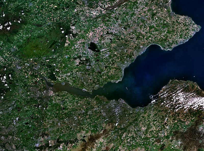
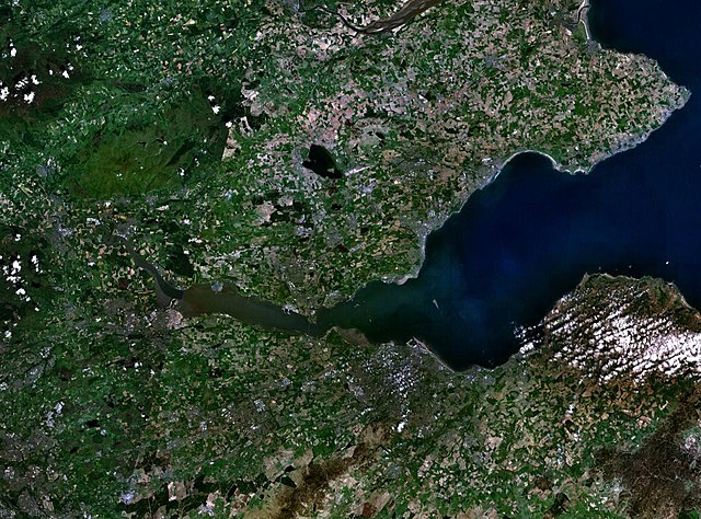
English: The Firth of the river Forth, on the east coast of Scotland. The two forth bridges are visible near the centre of the frame. Stirling is at the extreme left side. |
| Dyddiad | 3 Awst 2005 (upload date) |
| Ffynhonnell | Satellite imagery taken by screenshot from NASA World Wind software |
| Awdur | NASA |
Trwyddedu
| This image is in the public domain because it is a screenshot from NASA’s globe software World Wind using a public domain layer, such as Blue Marble, MODIS, Landsat, SRTM, USGS or GLOBE.
|
 |
Hanes y ffeil
Cliciwch ar ddyddiad / amser i weld y ffeil fel ag yr oedd bryd hynny.
| Dyddiad / Amser | Bawdlun | Hyd a lled | Defnyddiwr | Sylw | |
|---|---|---|---|---|---|
| cyfredol | 09:38, 3 Awst 2005 | | 1,280 × 948 (289 KB) | Finlay McWalter | The Firth of the river Forth, on the east coast of Scotland. The two forth bridges are visible near the centre of the frame. Stirling is at the extreme left side. Image made with NASA World Wind. {{PD-USGov-NASA}} category:satellite photos |
Cysylltiadau'r ffeil
Mae'r 1 tudalennau a ddefnyddir isod yn cysylltu i'r ddelwedd hon:
Defnydd cydwici y ffeil
Mae'r wicis eraill hyn yn defnyddio'r ffeil hon:
- Y defnydd ar ar.wikipedia.org
- Y defnydd ar be.wikipedia.org
- Y defnydd ar bg.wikipedia.org
- Y defnydd ar br.wikipedia.org
- Y defnydd ar ca.wikipedia.org
- Y defnydd ar ceb.wikipedia.org
- Y defnydd ar cs.wikipedia.org
- Y defnydd ar de.wikipedia.org
- Y defnydd ar el.wikipedia.org
- Y defnydd ar en.wikipedia.org
- Y defnydd ar en.wikivoyage.org
- Y defnydd ar eo.wikipedia.org
- Y defnydd ar es.wikipedia.org
- Y defnydd ar et.wikipedia.org
- Y defnydd ar eu.wikipedia.org
- Y defnydd ar fa.wikipedia.org
- Y defnydd ar fr.wikipedia.org
- Y defnydd ar ga.wikipedia.org
- Y defnydd ar gd.wikipedia.org
- Y defnydd ar ha.wikipedia.org
- Y defnydd ar he.wikipedia.org
- Y defnydd ar hi.wikipedia.org
- Y defnydd ar ia.wikipedia.org
- Y defnydd ar is.wikipedia.org
- Y defnydd ar it.wikipedia.org
- Y defnydd ar it.wikivoyage.org
- Y defnydd ar ja.wikipedia.org
- Y defnydd ar kbd.wikipedia.org
- Y defnydd ar lt.wikipedia.org
- Y defnydd ar mt.wikipedia.org
- Y defnydd ar nl.wikipedia.org
- Y defnydd ar nn.wikipedia.org
- Y defnydd ar no.wikipedia.org
- Y defnydd ar pl.wikipedia.org
- Y defnydd ar pt.wikipedia.org
- Y defnydd ar ro.wikipedia.org
- Y defnydd ar ru.wikipedia.org
- Y defnydd ar sco.wikipedia.org
Gweld rhagor o'r defnydd cydwici o'r ffeil hon.