
Delwedd:Uffington-White-Horse-sat.jpg
Wedi ei chwyddo hyd yr eithaf.
Uffington-White-Horse-sat.jpg ((640 × 480 picsel, maint y ffeil: 95 KB, ffurf MIME: image/jpeg))
Crynodeb
| Disgrifiad |
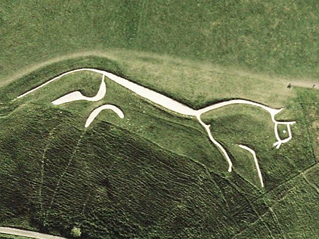
English: Sattelite view of the Uffington White Horse |
| Ffynhonnell | World Wind (go) |
| Awdur | USGS |
| Camera location | | View this and other nearby images on: OpenStreetMap |
|---|
Trwyddedu
| This file is in the public domain in the United States because it was solely created by NASA. NASA copyright policy states that "NASA material is not protected by copyright unless noted". (See Template:PD-USGov, NASA copyright policy page or JPL Image Use Policy.) | ||
 |
Warnings:
|
Hanes y ffeil
Cliciwch ar ddyddiad / amser i weld y ffeil fel ag yr oedd bryd hynny.
| Dyddiad / Amser | Bawdlun | Hyd a lled | Defnyddiwr | Sylw | |
|---|---|---|---|---|---|
| cyfredol | 16:33, 30 Mehefin 2008 | | 640 × 480 (95 KB) | Danielgrad~commonswiki | {{Information |Description={{en|1=Sattelite view of the Uffington White Horse}} |Source=World Wind ([worldwind://goto/world=Earth&lat=51.577721&lon=-1.566598&view=0.001 go]) |Author=USGS |Date= |Permi |
Cysylltiadau'r ffeil
Mae'r 1 tudalennau a ddefnyddir isod yn cysylltu i'r ddelwedd hon:
Defnydd cydwici y ffeil
Mae'r wicis eraill hyn yn defnyddio'r ffeil hon:
- Y defnydd ar af.wikipedia.org
- Y defnydd ar bg.wikipedia.org
- Y defnydd ar bn.wikipedia.org
- Y defnydd ar ca.wikipedia.org
- Y defnydd ar ceb.wikipedia.org
- Y defnydd ar cs.wikipedia.org
- Y defnydd ar da.wikipedia.org
- Y defnydd ar de.wikipedia.org
- Y defnydd ar en.wikipedia.org
- XTC
- South East England
- Oxfordshire
- Rohan, Middle-earth
- Uffington White Horse
- Style (visual arts)
- Berkshire Downs
- Animal worship
- British Iron Age
- English Settlement
- Geoglyph
- Hill figure
- Horse worship
- Timeline of prehistoric Britain
- User talk:Chzz/Archive 29
- History of the horse in Britain
- Scheduled monuments in Oxfordshire
- Y defnydd ar en.wikiquote.org
- Y defnydd ar en.wikivoyage.org
- Y defnydd ar en.wiktionary.org
- Y defnydd ar eo.wikipedia.org
- Y defnydd ar es.wikipedia.org
Gweld rhagor o'r defnydd cydwici o'r ffeil hon.