
Delwedd:Site of Battle of Pwll Melyn (sometimes known as Castle Oak Pond).jpg
Wedi ei chwyddo hyd yr eithaf.
Site_of_Battle_of_Pwll_Melyn_(sometimes_known_as_Castle_Oak_Pond).jpg ((640 × 426 picsel, maint y ffeil: 122 KB, ffurf MIME: image/jpeg))
.jpg)
Crynodeb
| Disgrifiad |
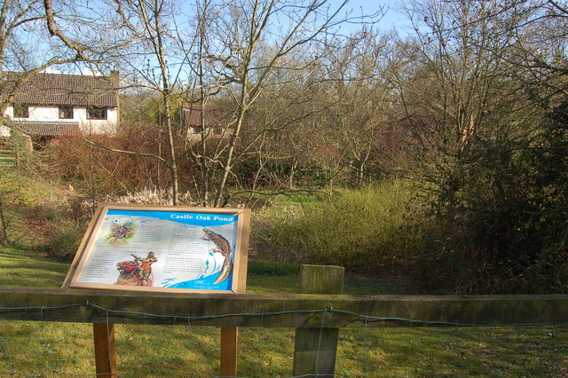
English: Castle Oak pond, Usk This pond was originally excavated in the 1850s to provide water for the steam trains on the line between Little Mill and Monmouth. During the excavation skeletons were found believed to be those slain at the battle of Pwll Melyn in 1405 when Owen Glendower's forces were heavily defeated by those of Henry IV. The line was closed in 1955 by Lord Beeching. Despite now being totally surrounded by the Castle Oak housing estate the pond is home to a rare amphibian -the greater crested newt. |
| Dyddiad | |
| Ffynhonnell | From geograph.org.uk |
| Awdur | Roger Davies |
| Cydnabyddiaeth (required by the license) | Roger Davies / Castle Oak pond, Usk / |
| Camera location | | View this and other nearby images on: OpenStreetMap |
|---|
.jpg¶ms=051.707020_N_-002.901200_E_globe:Earth_type:camera_source:geograph-osgb36(SO37820130)_heading:157.00&language=cy)
| Object location | | View this and other nearby images on: OpenStreetMap |
|---|
.jpg¶ms=051.706750_N_-002.901000_E_globe:Earth_class:object_type:object_source:geograph-osgb36(SO37830127)_heading:157.00&language=cy)
Trwyddedu

|
This image was taken from the Geograph project collection. See this photograph's page on the Geograph website for the photographer's contact details. The copyright on this image is owned by Roger Davies and is licensed for reuse under the Creative Commons Attribution-ShareAlike 2.0 license.
|
Trwyddedir y ffeil hon yn ôl termau'r drwydded Creative Commons Attribution-Share Alike 2.0 Generic.
Cydnabyddiaeth: Roger Davies
- Mae'n rhydd i chi:
- rhannu – gallwch gopïo, dosbarthu a throsglwyddo'r gwaith
- ailwampio – gallwch addasu'r gwaith
- Ar yr amodau canlynol:
- cydnabyddiaeth – Mae'n rhaid i chi nodi manylion y gwaith hwn, rhoi dolen i'r drwydded, a nodi os y bu golygu arni, yn y modd a benwyd gan yr awdur neu'r trwyddedwr (ond heb awgrymu o gwbl eu bod yn eich cymeradwyo chi na'ch defnydd o'r gwaith).
- rhannu ar dermau tebyg – Os byddwch yn addasu'r gwaith hwn, neu yn ei drawsnewid, neu yn adeiladu arno, mae'n rhaid i chi ddosbarthu'r gwaith dan drwydded sy'n union yr un fath same a'r gwreiddiol.
Hanes y ffeil
Cliciwch ar ddyddiad / amser i weld y ffeil fel ag yr oedd bryd hynny.
| Dyddiad / Amser | Bawdlun | Hyd a lled | Defnyddiwr | Sylw | |
|---|---|---|---|---|---|
| cyfredol | 10:57, 19 Chwefror 2011 | | 640 × 426 (122 KB) | GeographBot | == {{int:filedesc}} == {{Information |description={{en|1=Castle Oak pond, Usk This pond was originally excavated in the 1850s to provide water for the steam trains on the line between Little Mill and Monmouth. During the excavation skeletons were found be |
Cysylltiadau'r ffeil
Mae'r 1 tudalennau a ddefnyddir isod yn cysylltu i'r ddelwedd hon:
Defnydd cydwici y ffeil
Mae'r wicis eraill hyn yn defnyddio'r ffeil hon:
- Y defnydd ar de.wikipedia.org
- Y defnydd ar en.wikipedia.org
- Y defnydd ar fr.wikipedia.org
- Y defnydd ar www.wikidata.org
.jpg)