
Delwedd:Satellite image of Lebanon in March 2002.jpg

Maint y rhagolwg: 470 × 599 picsel. Eglurdebau eraill: 188 × 240 picsel | 584 × 744 picsel.
Maint llawn ((584 × 744 picsel, maint y ffeil: 59 KB, ffurf MIME: image/jpeg))
Crynodeb
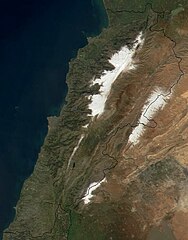
| Disgrifiad | Satellite image of Lebanon in March 2002. |
| Dyddiad | |
| Ffynhonnell | Cropped from: http://visibleearth.nasa.gov/view_rec.php?id=2499 |
| Awdur | Jacques Descloitres, MODIS Land Rapid Response Team, NASA/GSFC |
| Diwygiadau eraill | Derivative works of this file: Jebel el gharbi in labanon satellite map.jpg |
Trwyddedu
| This file is in the public domain in the United States because it was solely created by NASA. NASA copyright policy states that "NASA material is not protected by copyright unless noted". (See Template:PD-USGov, NASA copyright policy page or JPL Image Use Policy.) | ||
 |
Warnings:
|
Hanes y ffeil
Cliciwch ar ddyddiad / amser i weld y ffeil fel ag yr oedd bryd hynny.
| Dyddiad / Amser | Bawdlun | Hyd a lled | Defnyddiwr | Sylw | |
|---|---|---|---|---|---|
| cyfredol | 14:06, 6 Ionawr 2005 | | 584 × 744 (59 KB) | Hautala | {{PD-USGov-NASA}} Satellite image of Lebanon in March 2002. Cropped image, original taken from NASA's Visible Earth http://visibleearth.nasa.gov/cgi-bin/viewrecord?12056 |
Cysylltiadau'r ffeil
Mae'r 1 tudalennau a ddefnyddir isod yn cysylltu i'r ddelwedd hon:
Defnydd cydwici y ffeil
Mae'r wicis eraill hyn yn defnyddio'r ffeil hon:
- Y defnydd ar ab.wikipedia.org
- Y defnydd ar af.wikipedia.org
- Y defnydd ar ar.wikipedia.org
- Y defnydd ar ar.wikiquote.org
- Y defnydd ar arz.wikipedia.org
- Y defnydd ar azb.wikipedia.org
- Y defnydd ar az.wikipedia.org
- Y defnydd ar ba.wikipedia.org
- Y defnydd ar be.wikipedia.org
- Y defnydd ar bg.wikipedia.org
- Y defnydd ar bn.wikipedia.org
- Y defnydd ar ca.wikipedia.org
- Y defnydd ar ceb.wikipedia.org
- Y defnydd ar ckb.wikipedia.org
- Y defnydd ar da.wikipedia.org
- Y defnydd ar de.wikipedia.org
- Y defnydd ar de.wiktionary.org
- Y defnydd ar el.wikipedia.org
- Y defnydd ar en.wikipedia.org
Gweld rhagor o'r defnydd cydwici o'r ffeil hon.