
Delwedd:Red dawn 1984 movie start of ww3.PNG

Maint y rhagolwg: 800 × 359 picsel. Eglurdebau eraill: 320 × 144 picsel | 640 × 287 picsel | 1,400 × 628 picsel.
Maint llawn ((1,400 × 628 picsel, maint y ffeil: 49 KB, ffurf MIME: image/png))

|
This map, as well as other fictitious maps, is fictitious or too incorrect (i.e. due to anachronism) to be used in real-life contexts (contemporary or historic). It may have some visual elements that are similar to official maps such as colors or certain layout features, but they are NOT official and don't have any official recognition. |
Crynodeb
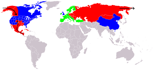
Map of fictional events in the 1984 movie Red Dawn, at the start of World War III.
- Blue = US and allies (United Kingdom "England", China "600 million screaming Chinamen", presumably Unoccupied Canada)
- Green = Neutral (Europe, "they're sitting this one out")
- Red = USSR and allies (showing USSR invasion of Alaska "stopped butt cold" at the contiguous 48 US border, Occupied Canadian Provinces of British Columbia, Western portion of Alberta and the Yukon Territory, Honduras, El Salvador, and Guatemala fall, Mexico in revolution, Texas described as being behind enemy lines, Oklahoma and most of Kansas, Louisiana, Arkansas, and Missouri probably overrun too, Colorado where the movie is set - invasion force stopped at Cheyenne, Wyoming. Blue circle shows Denver under siege.)
- Grey = Unknown
- Red squares = use of Soviet nuclear weapons - Beijing "there were", Washington, Kansas City & Omaha
At the end of the movie the US is implied on a plaque as having won the war, although how they did it is not explained.
If The US stopped them at the Mississippi River, then the color used for the US state Mississippi is incorrect. Mississippi would be part of F.A. (Free America) not occupied as the map indicates.
Trwyddedu

|
Caniateir copïo, dosbarthu a/neu golygu'r ddogfen hon yn ôl telerau'r Drwydded Ddogfennaeth Rydd GNU, Fersiwn 1.2 neu unrhyw fersiwn diweddarach a gyhoeddwyd gan y Free Software Foundation; yn cynnwys dim Adrannau Di-syfl, dim Testunau Clawr Blaen, a dim Testunau Clawr Cefn. Cynhwysir copi o'r drwydded hon yn yr adran Trwydded Ddogfennaeth Rydd GNU". |
| Trwyddedir y ffeil hon yn ôl termau'r drwydded Creative Commons Attribution-Share Alike 3.0 Unported. | ||
| ||
| Ychwangwyd y nod trwyddedu hwn wrth y ffeil hon yn ran o'r gwaith o ddiweddaru trwyddedau GFDL. |

|
This fictional map image could be re-created using vector graphics as an SVG file. This has several advantages; see Commons:Media for cleanup for more information. If an SVG form of this image is available, please upload it and afterwards replace this template with
{{vector version available|new image name}}.
It is recommended to name the SVG file “Red dawn 1984 movie start of ww3.svg”—then the template Vector version available (or Vva) does not need the new image name parameter. |
Hanes y ffeil
Cliciwch ar ddyddiad / amser i weld y ffeil fel ag yr oedd bryd hynny.
| Dyddiad / Amser | Bawdlun | Hyd a lled | Defnyddiwr | Sylw | |
|---|---|---|---|---|---|
| cyfredol | 20:09, 23 Rhagfyr 2008 | | 1,400 × 628 (49 KB) | Shibo77 | {{Information |Description=.. |Source=Roke |Date=.. |Author=Roke |Permission=.. |other_versions=.. }} <!--{{ImageUpload|basic}}--> |
| 12:36, 18 Mehefin 2008 |  | 1,400 × 628 (49 KB) | Peephole | {{Information |Description= |Source= |Date= |Author= |Permission= |other_versions= }} | |
| 01:14, 5 Hydref 2007 |  | 1,400 × 628 (49 KB) | Hoshie | added Cabinda (between Angola and Zaire), fixed YAR/PDRY boundary. | |
| 19:17, 10 Medi 2007 |  | 1,400 × 628 (49 KB) | Bart133 | == Summary == Map of fictional events in 1984 movie Red Dawn, at the start of World War III *Blue = US and allies (United Kingdom, China "600 million screaming Chinamen", presumably Unoccupied Canada) *Green = Neutral (Europe, "they're sitting this one o | |
| 00:54, 13 Ebrill 2006 |  | 1,400 × 628 (49 KB) | Roke~commonswiki | Map of fictional events in 1984 movie Red Dawn, at the start of World War III Blue = US and allies (England, China "600 million screaming Chinamen", presumably Canada) Green = Neutral (Europe, "theyre sitting this one out") Red = USSR and allies (showing |
Cysylltiadau'r ffeil
Mae'r 1 tudalennau a ddefnyddir isod yn cysylltu i'r ddelwedd hon:
Defnydd cydwici y ffeil
Mae'r wicis eraill hyn yn defnyddio'r ffeil hon:
- Y defnydd ar ar.wikipedia.org
- Y defnydd ar ca.wikipedia.org
- Y defnydd ar de.wikipedia.org
- Y defnydd ar en.wikipedia.org
- Y defnydd ar eo.wikipedia.org
- Y defnydd ar es.wikipedia.org
- Y defnydd ar eu.wikipedia.org
- Y defnydd ar fi.wikipedia.org
- Y defnydd ar fr.wikipedia.org
- Y defnydd ar id.wikipedia.org
- Y defnydd ar it.wikipedia.org
- Y defnydd ar ja.wikipedia.org
- Y defnydd ar ko.wikipedia.org
- Y defnydd ar ms.wikipedia.org
- Y defnydd ar nds.wikipedia.org
- Y defnydd ar nl.wikipedia.org
- Y defnydd ar no.wikipedia.org
- Y defnydd ar pl.wikipedia.org
- Y defnydd ar pt.wikipedia.org
- Y defnydd ar ru.wikipedia.org
- Y defnydd ar simple.wikipedia.org
- Y defnydd ar sv.wikipedia.org
- Y defnydd ar uk.wikipedia.org
- Y defnydd ar zh.wikipedia.org