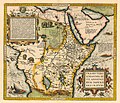
Delwedd:Prester John map.jpg

Maint y rhagolwg: 700 × 599 picsel. Eglurdebau eraill: 280 × 240 picsel | 561 × 480 picsel | 897 × 768 picsel | 1,196 × 1,024 picsel | 2,420 × 2,072 picsel.
Maint llawn ((2,420 × 2,072 picsel, maint y ffeil: 3.71 MB, ffurf MIME: image/jpeg))
Hanes y ffeil
Cliciwch ar ddyddiad / amser i weld y ffeil fel ag yr oedd bryd hynny.
| Dyddiad / Amser | Bawdlun | Hyd a lled | Defnyddiwr | Sylw | |
|---|---|---|---|---|---|
| cyfredol | 02:18, 15 Tachwedd 2018 |  | 2,420 × 2,072 (3.71 MB) | Plank | Resolución |
| 13:21, 31 Ionawr 2007 |  | 528 × 450 (54 KB) | Woudloper | {{Information |Description=A map of Prester John's kingdom as Ethiopia. (the original uploader didn't provide info on the author or date of the map) |Source=English wikipedia |Date= |Author=originally uploaded by en:user:Cuchullain |Permission={{PD-old}} |
Cysylltiadau'r ffeil
Mae'r 1 tudalennau a ddefnyddir isod yn cysylltu i'r ddelwedd hon:
Defnydd cydwici y ffeil
Mae'r wicis eraill hyn yn defnyddio'r ffeil hon:
- Y defnydd ar ca.wikipedia.org
- Y defnydd ar cs.wikipedia.org
- Y defnydd ar de.wikipedia.org
- Y defnydd ar en.wikipedia.org
- Y defnydd ar es.wikipedia.org
- Y defnydd ar fi.wikipedia.org
- Y defnydd ar fr.wikipedia.org
- Y defnydd ar ga.wikipedia.org
- Y defnydd ar gl.wikipedia.org
- Y defnydd ar he.wikipedia.org
- Y defnydd ar id.wikipedia.org
- Y defnydd ar it.wikipedia.org
- Y defnydd ar ja.wikipedia.org
- Y defnydd ar nl.wikipedia.org
- Y defnydd ar pt.wikipedia.org
- Y defnydd ar ro.wikipedia.org
- Y defnydd ar ru.wikipedia.org
- Y defnydd ar sr.wikipedia.org
- Y defnydd ar uk.wikipedia.org


