
Delwedd:Post medieval, Anti-papist pipe tamper (FindID 525592).jpg
Maint y rhagolwg: 611 × 600 picsel. Eglurdebau eraill: 244 × 240 picsel | 489 × 480 picsel | 782 × 768 picsel | 1,043 × 1,024 picsel | 1,930 × 1,895 picsel.
Maint llawn ((1,930 × 1,895 picsel, maint y ffeil: 1.58 MB, ffurf MIME: image/jpeg))
.jpg)
Crynodeb
| Post medieval: Anti-papist pipe tamper | |||
|---|---|---|---|
| Ffotograffydd |
Berkshire Archaeology, David Williams, 2012-10-31 12:28:17 |
||
| Teitl |
Post medieval: Anti-papist pipe tamper |
||
| Disgrifiad |
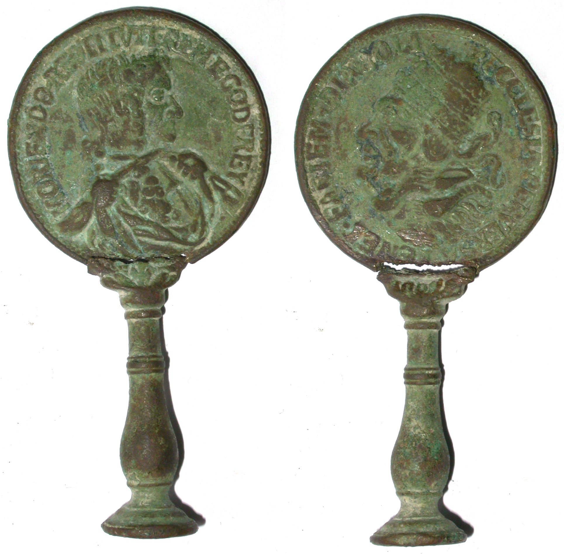
English: A complete cast copper alloy clay tobacco pipe tamper, now in two pieces. The head of the tamper is made using the design of a contemporary anti-papist medallion (diam.12.92mm) issued in 1678. The shaft of the tamper is of baluster form.
Side 1. The head of the pope in profile; when inverted he appears as the devil. ECCLESIA.PERVERSA.TENET.FACIEM.DIABOLI The church subverted takes on the face of the Devil. Side 2. Bust of Sir Edmundbury Godfrey facing right. MORTENDO.RESTITVIT.REM.E.GODFREY E(dmundbury) Godfrey by his death re-established the state. Godfrey was believed to have been murdered by Catholics on 12th October 1678. |
||
| Depicted place | (County of findspot) West Berkshire | ||
| Dyddiad | 1678 | ||
| Rhif catalogio |
FindID: 525592 Old ref: SUR-0101B2 Filename: B12-370.JPG |
||
| Cydnabyddiaeth |
|
||
| Ffynhonnell |
https://finds.org.uk/database/ajax/download/id/402051 Catalog: https://finds.org.uk/database/images/image/id/402051/recordtype/artefacts archive copy at the Wayback Machine Artefact: https://finds.org.uk/database/artefacts/record/id/525592 |
||
| Caniatâd (Ailddefnyddio'r ffeil hon) |
Attribution-ShareAlike License version 4.0 (verified 22 Tachwedd 2020) | ||
| Object location | | View this and other nearby images on: OpenStreetMap |
|---|
.jpg¶ms=051.492400_N_-001.133280_E_globe:Earth_class:object_type:object__&language=cy)
Trwyddedu
Trwyddedir y ffeil hon yn ôl termau'r drwydded Creative Commons Attribution-Share Alike 4.0 International.
Cydnabyddiaeth: The Portable Antiquities Scheme/ The Trustees of the British Museum
- Mae'n rhydd i chi:
- rhannu – gallwch gopïo, dosbarthu a throsglwyddo'r gwaith
- ailwampio – gallwch addasu'r gwaith
- Ar yr amodau canlynol:
- cydnabyddiaeth – Mae'n rhaid i chi nodi manylion y gwaith hwn, rhoi dolen i'r drwydded, a nodi os y bu golygu arni, yn y modd a benwyd gan yr awdur neu'r trwyddedwr (ond heb awgrymu o gwbl eu bod yn eich cymeradwyo chi na'ch defnydd o'r gwaith).
- rhannu ar dermau tebyg – Os byddwch yn addasu'r gwaith hwn, neu yn ei drawsnewid, neu yn adeiladu arno, mae'n rhaid i chi ddosbarthu'r gwaith dan drwydded sy'n union yr un fath same a'r gwreiddiol.
Hanes y ffeil
Cliciwch ar ddyddiad / amser i weld y ffeil fel ag yr oedd bryd hynny.
| Dyddiad / Amser | Bawdlun | Hyd a lled | Defnyddiwr | Sylw | |
|---|---|---|---|---|---|
| cyfredol | 14:25, 10 Chwefror 2017 | | 1,930 × 1,895 (1.58 MB) | Fæ | Cropped 8 % horizontally and 15 % vertically using CropTool with lossless mode. |
| 17:20, 30 Ionawr 2017 |  | 2,087 × 2,229 (1.62 MB) | Fæ | Portable Antiquities Scheme, SUR, FindID: 525592, post medieval, page 2406, batch count 10018 |
Cysylltiadau'r ffeil
Mae'r 1 tudalennau a ddefnyddir isod yn cysylltu i'r ddelwedd hon:
Defnydd cydwici y ffeil
Mae'r wicis eraill hyn yn defnyddio'r ffeil hon:
- Y defnydd ar en.wikipedia.org
- Y defnydd ar fr.wikipedia.org
- Y defnydd ar it.wikipedia.org
.jpg)