
Delwedd:Pollution in Maracaibo lake.jpg
Maint y rhagolwg: 800 × 429 picsel. Eglurdebau eraill: 320 × 171 picsel | 640 × 343 picsel | 1,024 × 549 picsel | 1,280 × 686 picsel | 2,560 × 1,372 picsel | 4,588 × 2,458 picsel.
Maint llawn ((4,588 × 2,458 picsel, maint y ffeil: 8.98 MB, ffurf MIME: image/jpeg))
Crynodeb
| Disgrifiad |
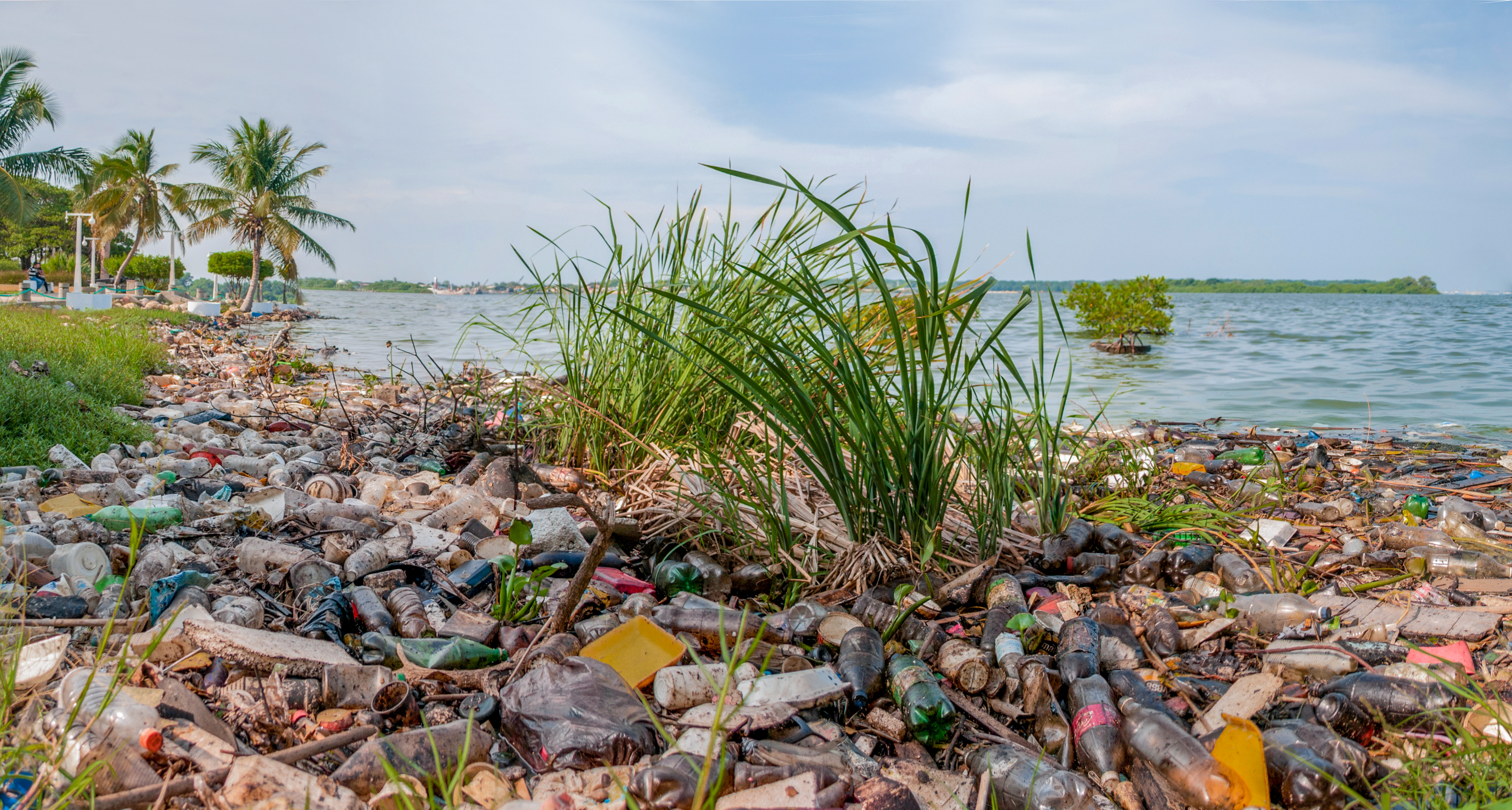
Español: El Lago de Maracaibo se encuentra ubicado en el Estado Zulia, Venezuela, es el lago mas grande de Sudamerica con un area de 13.820 km²[1], es común observar este tipo de contaminación a lo largo de todas sus costas contaminadas con lemmna sp, derrames de petroleo y desechos humanos son los principales contaminantes. Las actividades agrícolas, pecuarias, mineras e industriales, sin control, desarrolladas en la cuenca del Lago de Maracaibo, han originando un proceso acelerado de eutrofización en el mismo.[2]
English: Maracaibo Lake situated in Estado Zulia Venezuela is the biggest lake of South America with an area of 13820 km2[1], it is frequently to look this kind of pollution along of its coasts. It has lemna, oil spill, human waste as main pollutant. The uncontrolled agricultural activities, mining and industrial done in Maracaibo Lake Basin had started a rapid process of eutrophication on this place[2]. |
| Dyddiad | |
| Ffynhonnell | Gwaith yr uwchlwythwr |
| Awdur | Wilfredor |
| Camera location | | View this and other nearby images on: OpenStreetMap |
|---|

|
NOTE: This image is a panorama consisting of multiple frames that were merged or stitched in software. As a result, this image necessarily underwent some form of digital manipulation. These manipulations may include blending, blurring, cloning, and colour and perspective adjustments. As a result of these adjustments, the image content may be slightly different from reality at the points where multiple images were combined. This manipulation is often required due to lens, perspective, and parallax distortions.
|
This photograph was taken with a Nikon D300
References
- ↑ a b Maracaibo lake extension
- ↑ a b Eutrophication and Activities uncontrolled in Maracaibo lake extension
Trwyddedu
Yr wyf fi, deiliad yr hawlfraint ar y gwaith hwn, yn ei gyhoeddi yn ôl termau'r drwydded a ganlyn:
Trwyddedir y ffeil hon yn ôl termau'r drwydded Creative Commons Attribution-Share Alike 3.0 Unported.
- Mae'n rhydd i chi:
- rhannu – gallwch gopïo, dosbarthu a throsglwyddo'r gwaith
- ailwampio – gallwch addasu'r gwaith
- Ar yr amodau canlynol:
- cydnabyddiaeth – Mae'n rhaid i chi nodi manylion y gwaith hwn, rhoi dolen i'r drwydded, a nodi os y bu golygu arni, yn y modd a benwyd gan yr awdur neu'r trwyddedwr (ond heb awgrymu o gwbl eu bod yn eich cymeradwyo chi na'ch defnydd o'r gwaith).
- rhannu ar dermau tebyg – Os byddwch yn addasu'r gwaith hwn, neu yn ei drawsnewid, neu yn adeiladu arno, mae'n rhaid i chi ddosbarthu'r gwaith dan drwydded sy'n union yr un fath same a'r gwreiddiol.
Mae'r llun hwn wedi cael ei asesu yn ôl gofynion y Canllaw i Luniau Graenus ac yn cael ei gyfrif ymhlith y Lluniau Graenus.
|
Hanes y ffeil
Cliciwch ar ddyddiad / amser i weld y ffeil fel ag yr oedd bryd hynny.
| Dyddiad / Amser | Bawdlun | Hyd a lled | Defnyddiwr | Sylw | |
|---|---|---|---|---|---|
| cyfredol | 01:02, 2 Tachwedd 2012 | | 4,588 × 2,458 (8.98 MB) | Wilfredor | User created page with UploadWizard |
Cysylltiadau'r ffeil
Mae'r 1 tudalennau a ddefnyddir isod yn cysylltu i'r ddelwedd hon:
Defnydd cydwici y ffeil
Mae'r wicis eraill hyn yn defnyddio'r ffeil hon:
- Y defnydd ar ast.wikipedia.org
- Y defnydd ar ca.wikipedia.org
- Y defnydd ar dag.wikipedia.org
- Y defnydd ar de.wikiversity.org
- Y defnydd ar en.wikipedia.org
- Y defnydd ar es.wikipedia.org
- Y defnydd ar ha.wikipedia.org
- Y defnydd ar la.wikipedia.org
- Y defnydd ar lv.wikipedia.org
- Y defnydd ar uk.wikipedia.org
- Y defnydd ar www.wikidata.org